


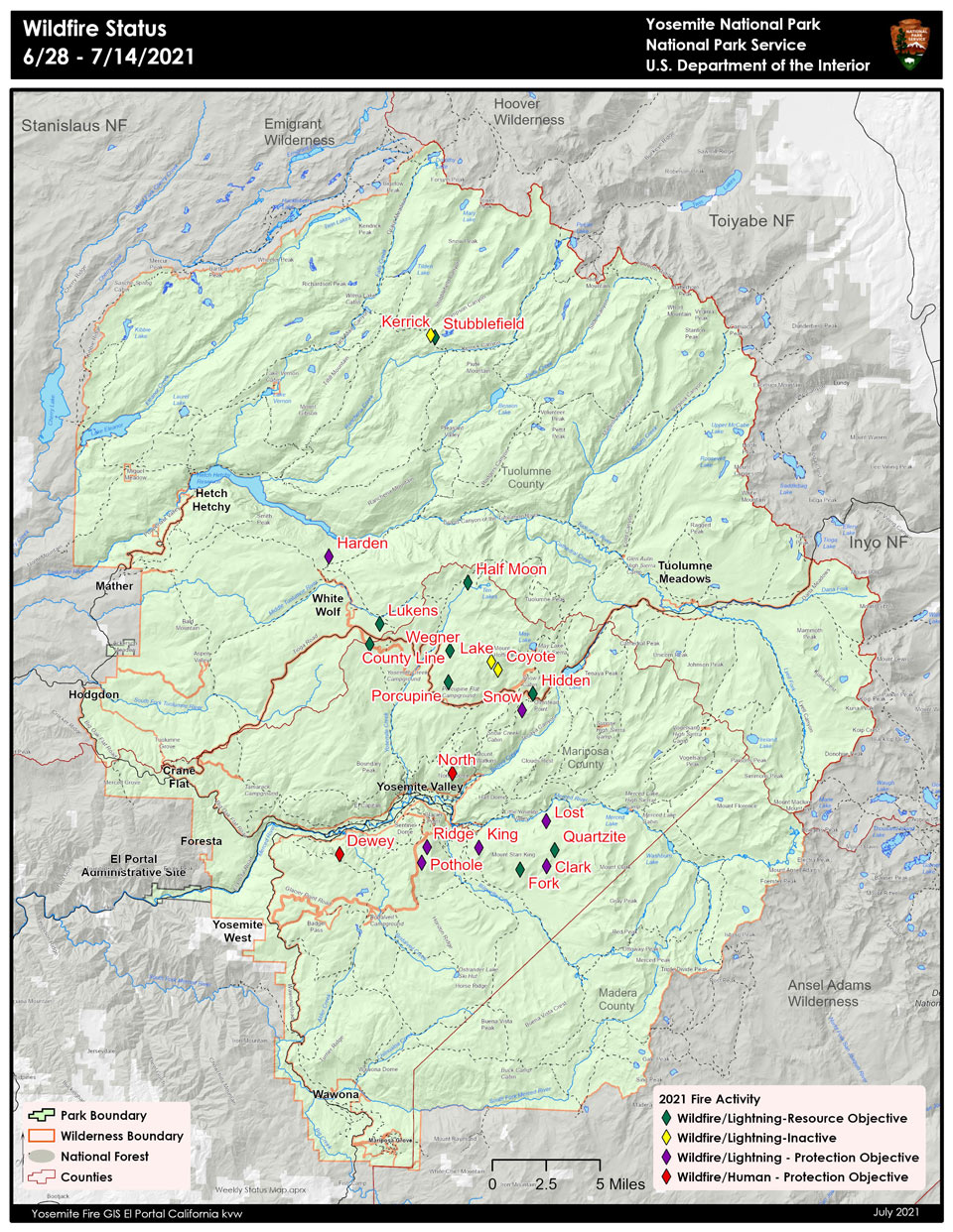
July 16, 2021 - On Monday, June 28, 2021, through July 2, thunderstorms developed over Yosemite National Park, creating lightning that ignited 19 fires. Fire managers have been assessing all fires for an appropriate response. Ten fires have been contained due to location and spread potential. There are six remaining fires that are burning in high elevation areas located in wilderness ranging from 7,000 to 9,700 feet and are actively being monitored. The Lukens Fire and County Line Fire are being suppressed using roads and trails to contain and confine, with additional burning to secure these fires into the Wolf and Blue Jay fire footprints from 2020.
Travelers along Tioga Road may experience delays with one-way traffic from White Wolf Junction to Mc Swain Summit. Firefighters and fire equipment will be working on this section of Tioga Road.
Yosemite National Park is a fire-adapted ecosystem. The overall strategy for managing all wildland fires is to provide for the safety of employees and the public and protect and enhance natural and cultural resources.
King
Location: South of Nevada Falls, north of Mount Starr King. 7220 elevation.
Discovery Date: June 29, 2021 Size: 10 acres
Containment: 100% Strategy: Suppression
Cause: Lightning
Quartzite
Location: West of Quartzsite Peak. 8781 elevation.
Discovery Date: June 29, 2021 Size: .5 acre
Containment: 0% Strategy: Monitor
Cause: Lightning
Stubblefield
Location: Northern end of Yosemite NP, 2000 feet from Pacific Crest Trail (mile marker 982), no threat to trail. 8000 elevation.
Discovery Date: June 28, 2021 Size: 2 acres
Containment: 0% Strategy: Monitor
Cause: Lightning
Porcupine
Location: Northeast of Porcupine Campground, and Tioga Road. 8210 elevation.
Discovery Date: June 28, 2021 Size: 3.7 acres
Containment: 0% Strategy: Monitor
Cause: Lightning
Hidden
Location: Northwest of Olmsted Point, Tioga Road. 9017 elevation.
Discovery Date: June 28, 2021 Size: .1 acre
Containment: 0% Strategy: Monitor
Cause: Lightning
County Line
Location: Near Yosemite Creek Campground Road. 8361 elevation.
Discovery Date: June 28, 2021 Size: 170 acres
Containment: 60% Strategy: Confine and Contain
Cause: Lightning
Lukens
Location: West of Lukens Lake, North of Tioga Road. 8243 elevation.
Discovery Date: June 28, 2021 Size: 450 acres
Containment: 0% Strategy: Confine and Contain
Cause: Lightning
Wegner
Location: East of Yosemite Creek Picnic Area and east of Tioga Road. 8256 elevation.
Discovery Date: June 28, 2021 Size: .25 acre
Containment: 0% Strategy: Monitor
Cause: Lightning
Half Moon
Location: West of Ten Lakes near Half Moon Meadow. 8256 elevation.
Discovery Date: June 28, 2021 Size: .1 acre
Containment: 0% Strategy: Monitor
Cause: Lightning
Fork
Location: One mile southeast of Mount Starr King. 8500 elevation.
Discovery Date: June 28, 2021 Size: 12 acres
Containment: 100% Strategy: Confine and Contain
Cause: Lightning
Lost
Location: Northeast Starr King Meadow. 8700 elevation.
Discovery Date: July 6, 2021 Size: .25 acre
Containment: 100% Strategy: Suppression
Cause: Lightning
Snow
Location: May Lake Trailhead, near Tioga Road. 8600 elevation.
Discovery Date: July 14, 2021 Size: .1 acre
Containment: 100% Strategy: Suppression
Cause: Lightning
Yosemite National Park is a fire-adapted ecosystem. The overall strategy for managing all wildland fires is to provide for the safety of employees and the public and protect and enhance natural and cultural resources.
For the most up-to-date fire information follow Inciweb: https://inciweb.nwcg.gov/
Yosemite Fires Map PDF download
Yosemite Fires Update 7.16.2021 PDF dowanload
-
Air Quality: Yosemite Air Quality Page or airnow.gov or airnow.gov/fires
-
Trail Closures: https://www.nps.gov/yose/planyourvisit/conditions.htm
-
Fire Restrictions: https://www.nps.gov/yose/planyourvisit/firerestrictions.htm
-
National Weather Service Yosemite area forecast: www.weather.gov/hanford
-
Sign-up for Alerts: go.nps.gov/alert
-
Yosemite National Park Fire Information webpage: go.nps.gov/yosefire
-
Facebook: @YosemiteFire
-
Twitter: @YosemiteFire
Source: NPS
