


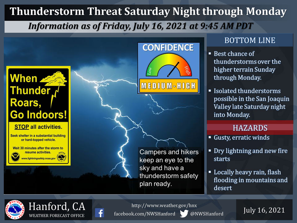
July 16, 2021 - The National Weather Service Hanford Office reports a northerly influx of monsoonal moisture into central California later this weekend into early next week will provide a favorable environment for the development of thunderstorms late Saturday night through Monday.
Some thunderstorms will bring dry lightning with a threat of new fire starts.
Thunderstorms will be more numerous in the mountains and occur primarily during the afternoon and evening hours. In addition to dangerous cloud to ground lightning, a few thunderstorms will bring heavy rain and a threat of flash flooding in the mountains and desert.
  Area Forecast Discussion
  National Weather Service Hanford CA
  427 AM PDT Fri Jul 16 2021


  .SYNOPSIS...Seasonal temperatures will continue for today. A
  warming trend will commence on Saturday, with high temperatures
  returning back above average for the majority of next week. There
  is a chance of daily showers and thunderstorms primarily in the
  Sierra mountains and Kern desert starting on Sunday and continuing
  through at least Tuesday.


  .DISCUSSION...Dry southwesterly flow will continue to prevail
  across the region today with seasonal high temperatures. Locally
  breezy conditions with wind gusts up to 35 mph will again occur
  along the West Side Hills, as well as through and below the Kern
  county mountain passes and desert this afternoon and evening. As
  indicated by the latest GOES-17 water vapor imagery, the airmass
  over our area is quite dry so I`m not expecting any showers or
  storms today.

  From Saturday through the majority of next week, the ensembles
  indicate that strong high pressure will build over the inter-
  mountain west. This will lead to a daily upward trend
  temperatures, with afternoon highs returning back above the
  century mark for most valley and Sierra foothill locations.
  However, we`re not expecting the same type of extreme heat as we
  just recently experienced, as the probability of reaching at least
  105 is less than 25% for locations in the valley and foothills.

  In addition to the warming temperatures, monsoon moisture will
  start to stream into the central California interior by as early
  as Saturday. Monsoon moisture will continue to work its way into
  the region through next week. By Sunday, there is a 30% to 40%
  chance of showers and isolated thunderstorms across the Sierra,
  with a 15% to 20% chance of showers and thunder in the Kern county
  desert. More widespread shower and thunderstorm activity is
  likely across the Sierra on Monday. Showers could also make their
  way into the lower foothills and possibly the valley floor on
  Sunday night and again on Monday. Current NBM guidance shows that
  KBFL has a 27% chance of at least 0.01" on Sunday and a 18%
  chance of at least 0.01" on Monday.


  .AVIATION...
  VFR conditions will prevail over the central California interior
  during the next 24 hours.

  &&

  .AIR QUALITY ISSUES...
  On Friday July 16 2021... Unhealthy for sensitive groups in Kern
  County and Sequoia National Park and Forest.
  Further information is available at Valleyair.org
Source: NWS
