


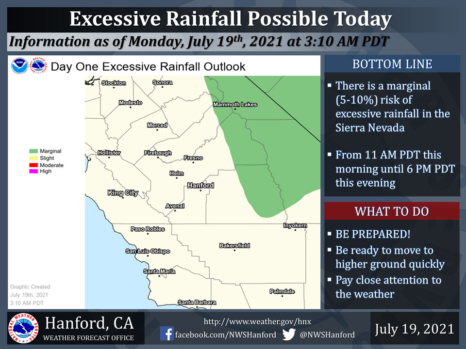
July 19, 2021 - The National Weather Service reports deep, monsoonal moisture in the higher terrain of Central California will be responsible for the possibility of heavy to excessive rainfall today.
There is a marginal (5-10%) risk of excessive rainfall in the Sierra Nevada into this evening.
  Area Forecast Discussion
  National Weather Service Hanford CA
  1217 PM PDT Mon Jul 19 2021

  .SYNOPSIS...Scattered showers and isolated thunderstorms will
  linger over the Sierra Nevada early this evening. Otherwise dry
  weather will prevail over the central California interior for
  the remainder of this week. A return of monsoonal moisture
  Saturday will renew the threat of thunderstorms over the
  mountains and desert this weekend.

  &&

  .DISCUSSION...Thunderstorms are rumbling about over the foothills
  and higher elevations of the Sierra as of this writing. Although a
  few of them are producing heavy rain, they`re moving quickly
  northward and not staying in any location long enough to bring a
  big threat of flooding. The precipitation these storms have dropped
  over the mountains and desert during the past 24 hours has been
  largely beneficial with rainfall in the heavier storms totaling as
  much as four tenths of an inch. Most of the thunderstorm activity
  over the Sierra will come to an end by sunset as winds aloft become
  southwesterly, sweep monsoonal moisture into the Great Basin and
  bring a drier and more stable air mass into the CWA. This has already
  happened this afternoon across southern CA, including Kern County,
  as high pressure over the Four Corners region has built into this
  part of the state. As this ridge builds back over central California,
  we can expect this drying trend to take place over the remainder of
  our CWA tonight.

  The rest of this week will be considerably quieter as the Four
  Corners ridge dominates. Mostly clear skies, generally light winds
  and slightly above normal high temperatures will be the rule
  Tuesday through at least Friday, as a result. Tuesday looks as
  though it will be our warmest day this week, but only by a few
  degrees. Otherwise, high temperatures will flirt with the century
  mark in the San Joaquin Valley and lower foothills during mid to
  late week. In the Kern county desert, triple digit heat will be a
  mainstay this week, but nothing as extreme as the heat earlier this
  month.

  The ensembles haven`t wavered much from run to run during the past
  couple of days and still hint of a return of monsoonal moisture
  into central California this weekend. Hence, we can expect a renewed
  threat of mainly afternoon and evening thunderstorms over the desert
  and mountains Saturday and probably again Sunday into early next week
  while a southeasterly flow prevails aloft. Otherwise the presence of
  mid and high clouds in the 5 to 7 day period might lower maximum
  temperatures a bit but also keep nightly temperatures a bit warmer
  along with somewhat higher humidity levels.

  &&


  .AVIATION...Isolated to scattered thunderstorms will continue over
  the Sierra until about 03z with local MVFR/IFR ceilings and
  mountain obscurations. VFR conditions will otherwise prevail
  over the central California interior during the next 24 hours.

  &&

  .AIR QUALITY ISSUES...
  On Monday July 19 2021... Unhealthy for sensitive groups in
  Fresno... Kern... Kings... Merced and Tulare Counties and Sequoia
  National Park and Forest.
  Further information is available at Valleyair.org
Source: NWS
