


California and National Drought Summary for July 20, 2021
Summary
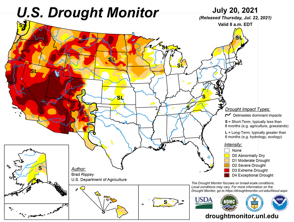
July 22, 2021 - Active weather prevailed across much of the South, East, and Midwest, as well as parts of the Plains, into the middle of July, followed by a southward shift in widespread shower activity. Meanwhile, a robust monsoon circulation provided limited Southwestern drought relief, particularly in parts of Arizona, New Mexico, and southwestern Colorado. Farther north and west, however, little or no rain fell in California, the Great Basin, and the Northwest, where dozens of wildfires were in various stages of containment. Smoke and other particulate matter from those fires carried downwind at various atmospheric levels, producing hazy skies and reducing air quality—in some cases thousands of miles from the points of origin. Dry weather extended eastward across the nation’s northern tier as far east as Lake Superior, while heavy rain eased or eradicated drought in the remainder of the Great Lakes region, along with the Northeast. In the driest areas of the northern and western United States, drought’s impact on water supplies, as well as rangeland, pastures, and a variety of crops, was further amplified by ongoing heat. Weekly temperatures averaged as much as 10°F above normal from the interior Northwest to the northern High Plains. On July 19, temperatures as high as 110°F were reported in eastern Montana. Another pocket of hot weather was centered over the middle Atlantic States. In contrast, near- or slightly below-normal temperatures dominated the Plains, Midwest, and South.
Northeast
Heavy rain extending from New York and northern Pennsylvania into parts of New England resulted in further reductions in the coverage of abnormal dryness (D0) and moderate to severe drought (D1 to D2). During the first 3 weeks of July, rainfall in some of New England’s non-drought areas has totaled 10 inches or more. In Worcester, Massachusetts, July 1-20 rainfall reached 12.70 inches (510% of normal). During the same period, Concord, New Hampshire received 10.69 inches (469% of normal). However, heavy rain has largely bypassed interior and northern sections of Maine, as well as northern portions of New Hampshire and Vermont. From July 1-20, rainfall in Caribou, Maine, totaled just 1.38 inches (48% of normal). Streamflow remains significantly below average for this time of year in the driest areas. Other drought-related impacts on rivers include elevated temperatures and low oxygens levels. In drought-affected areas, some berry crops have experienced varying levels of stress.
Southeast
The Southeast’s most meaningful patch of dryness (D0), extending from central Virginia into upstate South Carolina, remained intact. Due to ongoing drier-than-normal conditions; near- to above-normal temperatures; and mounting agricultural impacts, short-term moderate drought (D1) was introduced in parts of Virginia. On July 18, according to the U.S. Department of Agriculture, topsoil moisture was rated roughly one-third very short to short in Virginia (37%) and North Carolina (29%). On the same date, pastures were rated 35% very poor to poor in North Carolina, along with 26% in Virginia. Farther south, Alabama led the region on July 18 with topsoil moisture rated 39% surplus.
South
Patches of dryness (D0) and moderate drought (D1) have been relegated to a few areas in Oklahoma, Tennessee, and Texas. Broadly, there are few drought-related impacts in the South. Frequent summer rain events have maintained adequate to abundant soil moisture. On July 18, Mississippi led the region with topsoil moisture rated 33% surplus, according to the U.S. Department of Agriculture.
Midwest
An axis of heavy rain stretched from southern Missouri to northern Ohio. Secondary areas of locally heavy showers extended from Iowa and southeastern Minnesota to Michigan. The Midwestern rain intersected some existing areas of dryness (D0) and moderate to extreme drought (D1 to D3), resulting in some reductions in coverage. Some of the most dramatic improvements occurred across central Wisconsin and northern Lower Michigan. From July 13-15, more than 2 inches of rain soaked La Crosse, Wisconsin, and Traverse City, Michigan. Oshkosh, Wisconsin, received 3.34 inches. In contrast, little or no rain fell during the drought-monitoring period around Lake Superior and in central and northern Minnesota, where coverage of severe to extreme drought (D2 to D3) was greatly expanded. A broad array of indicators and indices, including streamflow, soil moisture, the Vegetation Health Index, the Evaporative Demand Drought Index, and the Standardized Precipitation Index, have shown that very serious drought conditions exist at a variety of times scales across much of northern and central Minnesota. On July 18, Minnesota led the Midwest with 63% of its pastures rated in very poor to poor condition, along with 42% of its spring wheat, 34% of its oats, 33% of its barley, 18% of its corn, and 17% of its soybeans. Minnesota also led the Midwest on that date, according to the U.S. Department of Agriculture, with topsoil moisture rated 78% very short to short.
High Plains
Scattered showers largely ended early in the drought-monitoring period. Meanwhile, extreme heat returned across northern portions of the region. Agricultural drought impacts across the northern High Plains remained widespread and severe, despite spotty showers. According to the U.S. Department of Agriculture, topsoil moisture on July 18 was rated 86% very short to short in North Dakota, along with 84% in South Dakota and 74% in Wyoming. Rangeland and pastures were rated at least one-half very poor to poor in Wyoming and the Dakotas, led by South Dakota at 78%. On July 18, North Dakota was the national leader in oats rated very poor to poor (50%; tied with South Dakota), along with soybeans (41%) and corn (32%). South Dakota led the nation, among major production states, in sorghum rated very poor to poor (29%). Nationally, the U.S. spring wheat crop was rated just 11% good to excellent and 63% very poor to poor on July 18, the lowest overall condition at this time of year since July 18, 1988, when the crop was categorized as 7% good to excellent and 73% very poor to poor. Initial estimates released by USDA on July 12 indicated that the 2021 U.S. spring wheat production will be down 41% from last year, while yield will be down 37%. If realized, the 2021 U.S. spring wheat yield of 30.7 bushels per acre would be the lowest since 2002.
West
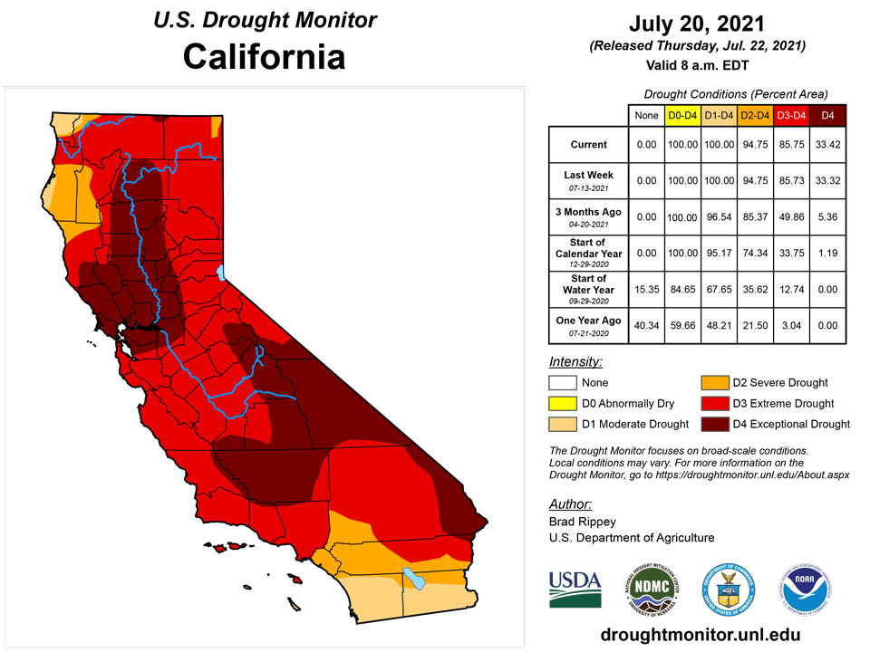
Showers associated with the Southwestern monsoon circulation provided limited drought relief in Arizona, New Mexico, and southwestern Colorado, while drought generally worsened across the northern Rockies and interior Northwest. The Western drought continued to act on multiple time scales, ranging from a few weeks (mostly agricultural impacts) to two decades (ecological and hydrological effects). Dozens of wildfires, primarily across northern California and the Northwest, continued to burn through hundreds of thousands of acres of timber, brush, and grass, aided by hot, dry conditions, dry soils, and ample fuels. Wildfire smoke continued to degrade air quality in many areas of the country, well outside the West. In southern Oregon, the nation’s largest active wildfire—the lightning-sparked Bootleg Fire—has consumed more than 394,000 acres of vegetation and has destroyed at least 184 structures. Meanwhile, Washington led the country in several drought-related agricultural categories, according to the U.S. Department of Agriculture. On July 18, Washington’s topsoil moisture was rated 98% very short to short—highest on record since the beginning of the 21st century. Prior to this year, the Washington state record of 89% very short to short had been set on September 10, 2017. Washington also led the country on July 18 in very poor to poor ratings for rangeland and pastures (96%), spring wheat (88%), and barley (63%). In addition to Washington, at least one-half of the rangeland and pastures were rated very poor to poor on that date in Montana (89%), Arizona (88%), Oregon (74%), Utah (72%), Nevada (65%), and Wyoming (52%). Partly due to the stunning drought-related impacts on agriculture, extreme to exceptional drought (D3 to D4) was broadly expanded across eastern Washington and environs, as well as parts of Montana and neighboring states. Moving to longer-term impacts, some of the West’s largest reservoirs and lakes continued to exhibit startling declines. The surface elevation of Lake Mead, on the Colorado River behind Hoover Dam, fell 135 feet in the 21-year period from July 1, 2000, to July 1, 2021, from 1,204 to 1,069 feet above sea level. By July 20, Lake Mead’s elevation stood at 1067.79 feet. Prior to the 21st century, Lake Mead’s surface elevation briefly fell below 1,100 feet only during two drought periods: 1955-57 and 1964-65. Since March 2014, the lake’s end-of-month surface elevation has been continuously below 1,100 feet—and currently stands at a record low since impoundment occurred more than 80 years ago. Farther upstream, water is being released from Flaming Gorge Reservoir in Wyoming and Utah to boost the level of Lake Powell for the purpose of guarding hydropower generating capability. Elsewhere in Utah, the surface elevation of the Great Salt Lake fell to 4,191.4 feet on July 20, tying the previous record low set in 1963. In California, 154 primary intrastate reservoirs gained just 1.7 million acre-feet of water during the 2021 melt season, barely 20% of the historical recharge average of 7.9 million acre-feet. At the end of June, the 154 reservoirs held just 62% of their typical volume for this time of year—and had lost 16.6 million acre-feet of water (49% of the original volume) over the last 2 years. Current California storage (17.5 million acre-feet) is less than 5.8 million acre-feet above what those reservoirs held on June 30, 1977, which was the year when statewide storage ultimately fell to a record-low end-of-month volume of 7.5 million acre-feet at the end of October. Finally, the punishing Western drought has been accompanied by record-setting high temperatures. The most recent northward shift in heat occurred as monsoon-related showers intensified across the Southwest. By July 19, Glasgow, Montana, reported a maximum temperature of 110°F—the highest reading in that location since July 18, 1936. It was also Glasgow’s third-highest temperature (tied with June 17, 1933) on record, behind only 113°F on July 31, 1900, and 112°F on July 18, 1936.
Caribbean
Elsewhere, there were no changes in Puerto Rico’s depiction of dryness (D0) and moderate drought (D1).
The weather conditions across the U.S. Virgin Islands (USVI) during this USDM week (07/14/21-07/20/21) consisted of alternating tropical systems. A Tropical Upper-Tropospheric Trough (TUTT) moved across the region early in the week, triggering showers which were locally heavy in a few northwest locations on the islands. A couple weak tropical waves followed, with generally light rainfall totals. A mass of drier air along with a mid-level ridge and a Saharan Dust Layer ended the week. Radar-based estimates of rainfall (QPE) for the 7 days ending at 12z on Tuesday showed generally less than an inch of rain, although amounts varied across the islands from less than a tenth to 2 inches. Satellite-based (IMERG) estimates of 7-day precipitation indicated totals generally less than half an inch. Rain gauge measurements ranged from a few tenths to three-fourths of an inch at most stations across the islands. Over an inch was recorded in northwestern parts of St. Thomas (1.52 inches) and St. Croix (3.21 inches).
So far in July, the month has been drier than normal at those regular reporting stations with climate normals. King AP on St. Thomas has reported 0.96 inch of rain in July, which is 55% of normal. On St. Croix, Rohlsen AP had 1.07 inches (66%) and the station at East Hill 0.95 inch (58%). The Windswept Beach CoCoRaHS station on St. John had 0.94 inch, which is 43% of the long-term average for this point in July.
Groundwater levels continued low. The USGS Grade School 3 well on St. Thomas rose from July 14 to July 15 but has been declining since, while the USGS wells on St. Croix and St. John continued to steadily decline.
The Standardized Precipitation Index (SPI) values showed little change from last week. Rohlsen AP still ranged from D0 at the 3-month time scale to D2 at 9 months, with D1 at 6 and 12 months. Windswept Beach was still D1 at 6 and 9 months. King AP was nearing D0 at 9 and 12 months, but still well below normal precipitation for the month and year to date. Based on these SPI values, below-normal precipitation, and continued low groundwater, D2-SL continued this week on St. Croix, D1-L continued on St. John, and D0-L continued on St. Thomas.
Pacific
Warm weather and short-term precipitation deficits across east-central Alaska led to some expansion of abnormal dryness (D0) and the introduction of a small area of moderate drought (D1). About a half-dozen wildfires are burning in the driest areas across interior Alaska; the largest blazes are the 50,000-acre Dry Creek Fire and the 44,000-acre Munson Creek Fire.
Meanwhile in Hawaii, expansion and intensification of drought was noted across parts of Maui and Oahu due to low streamflow values. Summer rainfall is typically light in leeward sections of Hawaii, but measurable precipitation was last observed in Kahului, Maui, on May 20. Windward sections of Hawaii have been receiving trade-wind showers, but amounts have been generally low. Namely, Maui experienced some changes from severe to extreme drought (D2 to D3) and from moderate to severe drought (D1 to D2). In southern Oahu, severe drought (D2) was introduced, while moderate drought (D1) expanded northward. There was a small increase in coverage of moderate drought (D1) across the northern tip of the Big Island.
In the U.S.-Affiliated Pacific Islands (USAPI) during this USDM week (07/14/21-07/20/21), an active, extensive, and robust Inter-Tropical Convergence Zone (ITCZ) spread abundant rain across much of central to eastern Micronesia during the first half of the week. A Tropical Upper Tropospheric Trough (TUTT) influenced the weather over western Micronesia, with its divergence aloft enhancing precipitation from surface troughs, especially over the Marianas. A tropical disturbance west of the Marianas developed into Tropical Storm In-Fa as it moved away from the region. A monsoon trough developed late in the week over western Micronesia, especially over the Marianas, associated with air flowing into TS In-Fa. Surface troughs and a couple weak circulations migrated through the easterly flow throughout the week. South of the equator, a weak shortwave trough brought some rain to the Samoan Islands, but high pressure and drier air dominated the region for much of the week.
Satellite-based estimates of 7-day precipitation (QPE) are available from two products: one using mainly infrared (IR) sensors (NESDIS GOES-R AHI) and the other incorporating microwave sensors (GPM IMERG). These QPE products showed less than half an inch of rain for the week across American Samoa. A wide swath of 4+ inches of rain was evident across the Federated States of Micronesia (FSM), with 2-4 inches estimated across the Marianas, Palau, and parts of the Marshall Islands (RMI).
Rain gauge reports for the week in the Marianas ranged from 1.26 inches at Dededo to 2.33 inches at Guam, with month-to-date precipitation totals for July ranging from 3.95 inches at Rota to 5.75 inches at Dededo. In Palau, the International Airport at Airai recorded 5.08 inches for the week and 11.51 inches for so far in July, while the values at the Koror COOP site were 3.98/10.94 inches. In the FSM, North Fanif recorded 1.87 inches and Lukunor 1.99 inches for the week, while the rest of the stations had weekly totals ranging from 2.67 inches at Yap to 8.08 inches at Kosrae. Monthly totals at the FSM stations for so far in July were well above the corresponding monthly minimum values that are used to trigger drought. In American Samoa, half an inch or less of rain was measured this week at Pago Pago (0.28 inch) and the automated stations at Siufaga Ridge (0.56) and Toa Ridge (0.39), but July monthly totals were well above the monthly minimum that triggers concern for drought. In the RMI, the week was wet (above the 2-inch weekly minimum) at Wotje (2.00 inches), Majuro (2.77), and Mili (4.05), but dry at Ailinglaplap (0.57), Kwajalein (1.34), and Jaluit (1.44).
The July to-date monthly total is 2.82 inches (well below the monthly minimum), and this week was the sixth consecutive dry week, so the status was changed to D0-S (short-term abnormal dryness) at Jaluit. With a dry week and the July to-date rainfall total only 1.88 inches, D0-S continued at Ailinglaplap. No data for the last several weeks meant no analysis could be made for Fananu and Utirik. Wet conditions meant D-Nothing (no drought or abnormal dryness) continued at the rest of the USAPI stations.
Looking Ahead
The interaction between the Southwestern monsoon circulation and a weak cold front will result in locally heavy rain in the Four Corners States but only light showers on the drought-stricken northern Plains. Five-day Southwestern rainfall totals could reach 1 to 3 inches or more, mainly in parts of Arizona, western New Mexico, and southwestern Colorado. Meanwhile, little or no rain will fall in the Pacific Coast States, northern Great Basin, northern Rockies, and central and southern Plains. Flash drought could become a concern across the central and southern Plains and upper Midwest, where building heat will accompany the dry weather. Meanwhile, significant rainfall (1 to 2 inches or more) should be limited to the Great Lakes and Northeastern States, as well as parts of the Southeast. Higher totals may occur in peninsular Florida. Elsewhere, a significant hot spell will persist into next week across an area centered over the northern Plains, with heat-related impacts reaching into the northern Rockies, Intermountain West, central Plains, and upper Midwest.
The NWS 6- to 10-day outlook for July 27 – 31 calls for the likelihood of hotter-than-normal weather nationwide, except for near-normal temperatures in the Northeast, Desert Southwest, and southern and western Alaska. Meanwhile, near- or below-normal rainfall in much of the country should contrast with wetter-than-normal weather across the Intermountain West, northern Great Basin, and western Alaska.
Author(s):
Brad Rippey, U.S. Department of Agriculture
Richard Heim, NOAA/NCEI
Dryness Categories
D0 Abnormally Dry—used for areas showing dryness but not yet in drought, or for areas recovering from drought.
Drought Intensity Categories
D1 Moderate Drought
D2 Severe Drought
D3 Extreme Drought
D4 Exceptional Drought
Drought or Dryness Types
S Short-term, typically less than 6 months (agriculture, grasslands)
L Long-term, typically more than 6 months (hydrology, ecology)
SL Area contains both short- and long-term impacts
Source: National Drought Mitigation Center
