


California and National Drought Summary for July 27, 2021
Summary
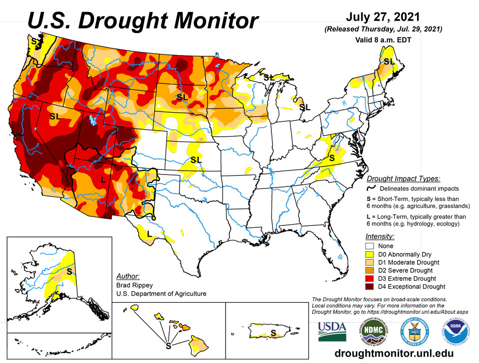
July 29, 2021 - A robust Southwestern monsoon circulation delivered drought-easing rainfall but sparked localized flash flooding across large sections of the Four Corners States, as well as the southern Great Basin, but critically dry conditions persisted across northern California and the Northwest. In the driest areas, wildfires—some sparked by lightning—dotted the landscape, with containment of some blazes hampered by high temperatures, low humidity levels, erratic winds, and abundant fuels. Farther east, another round of blistering heat across the northern Plains further stressed rangeland, pastures, and a variety of summer crops. The central and southern Plains also experienced some hot weather, although agricultural impacts were tempered by mostly adequate soil moisture reserves. Meanwhile, mostly dry weather covered the Midwest, continuing a trend that had developed in mid-July. Short-term dryness was not yet a concern in the previously well-watered lower Midwest. However, reproductive corn and soybeans in drier areas of the upper Midwest were subjected to increasing levels of stress, especially as temperatures began to rise. Elsewhere, Southeastern rain—which maintained abundant moisture reserves for pastures and summer crops—primarily fell from the Mississippi Delta to the southern Atlantic Coast.
Northeast
Wet weather continued to dent Northeastern drought, except in parts of West Virginia (and environs) and northern New England. Another week of frequent showers in non-drought areas of the Northeast pushed month-to-date (July 1-27) rainfall totals to a foot or more in some locations, including Worcester, Massachusetts (13.54 inches, or 399% of normal). Worcester’s previous wettest July occurred in 1938, when 11.41 inches fell. Farther north, however, July 1-27 rainfall in Caribou, Maine, totaled 2.77 inches (74% of normal). Lingering drought impacts in northern New England included low streamflow and groundwater shortages. Farther south, short-term dryness led to the introduction of some abnormal dryness (D0) and moderate drought (D1) in West Virginia and portions of neighboring states. In Elkins, West Virginia, July 1-27 rainfall totaled 2.24 inches, just 43% of normal.
Southeast
The last remaining patch of abnormal dryness (D0) in southern Florida was eradicated by ongoing showery weather. Neither dryness nor drought was present in Alabama and Georgia. Farther north however, dryness (D0) and moderate drought (D1) expanded across parts of western and central Virginia. By July 25, the U.S. Department of Agriculture reported that Virginia’s topsoil moisture was 60% very short to short, an increase of 23 percentage points from the previous week. On the same date, pastures were rated 38% in very poor to poor condition in Virginia, along with 43% in North Carolina. Some drier areas in the Carolinas received beneficial rain, however, resulting in reductions in the coverage of abnormal dryness (D0).
South
Arkansas, Louisiana, and Mississippi remained free of dryness and drought, while only small patches of abnormal dryness (D0) and moderate drought (D1) were noted in Oklahoma, Texas, and Tennessee. Most Southern crops continued to fare well amid plentiful rainfall and relatively mild temperatures. On July 25, three-quarters (75%) of the nation’s peanuts were rated in good to excellent condition, according to the U.S. Department of Agriculture, along with 73% of the rice and 61% of the cotton.
Midwest
Mostly dry weather developed across the Midwest in mid-July and has persisted for nearly 2 weeks. However, dryness was not yet a concern across the lower Midwest, where the U.S. Department of Agriculture noted (on July 25) that topsoil was rated 15% or less very short to short in Missouri, Illinois, Indiana, Ohio, and Michigan. In fact, Michigan was one of the few states in the region—along with northern Wisconsin—to receive widespread heavy showers in recent days. In stark contrast, drought continued to worsen across parts of the upper Midwest, accompanied by building heat. By July 25, topsoil moisture was rated 81% very short to short in Minnesota, along with 53% in Iowa and 46% in Nebraska. Iowa’s number markedly increased from last week’s 33% very short to short. Drought expansion highlights included additional extreme drought (D3) coverage in Minnesota and an increase in severe drought (D2) coverage in Iowa. At least one-fifth of Minnesota’s major summer crops—21% of the corn and 20% of the soybeans—were rated in very poor to poor condition on July 25. Minnesota also led the Midwest on that date with 66% of its pastures rated very poor to poor.
High Plains
Drought’s footprint remained rather limited across Kansas, eastern Colorado, and southern Nebraska. Farther north and west, however, worsening drought impacts were observed across much of Wyoming and the Dakotas. According to the U.S. Department of Agriculture, topsoil moisture on July 25 was rated 87% very short to short in North Dakota, along with 82% in South Dakota and 79% in Wyoming. Rangeland and pastures were rated at least 60% very poor to poor in Wyoming and the Dakotas, led by North Dakota at 85%. On July 25, North Dakota was the national leader in oats rated very poor to poor (56%), along with soybeans (41%) and corn (39%). South Dakota led the nation, among major production states, in sorghum rated very poor to poor (31%). Nationally, the U.S. spring wheat crop was rated just 9% good to excellent and 66% very poor to poor on July 25, the lowest overall condition at this time of year since July 25, 1988, when the crop was categorized as 4% good to excellent and 72% very poor to poor. Harvest was underway for drought-ravaged crops on the High Plains; 3% of the spring wheat had been cut by July 25. Periodic extreme heat on the northern Plains has greatly aggravated drought impacts. During the most recent heat wave, high temperatures in South Dakota on July 27 soared to 108°F in Pierre and 107°F in Rapid City. In the latter location, that represented the highest temperature since August 29, 2012.
West
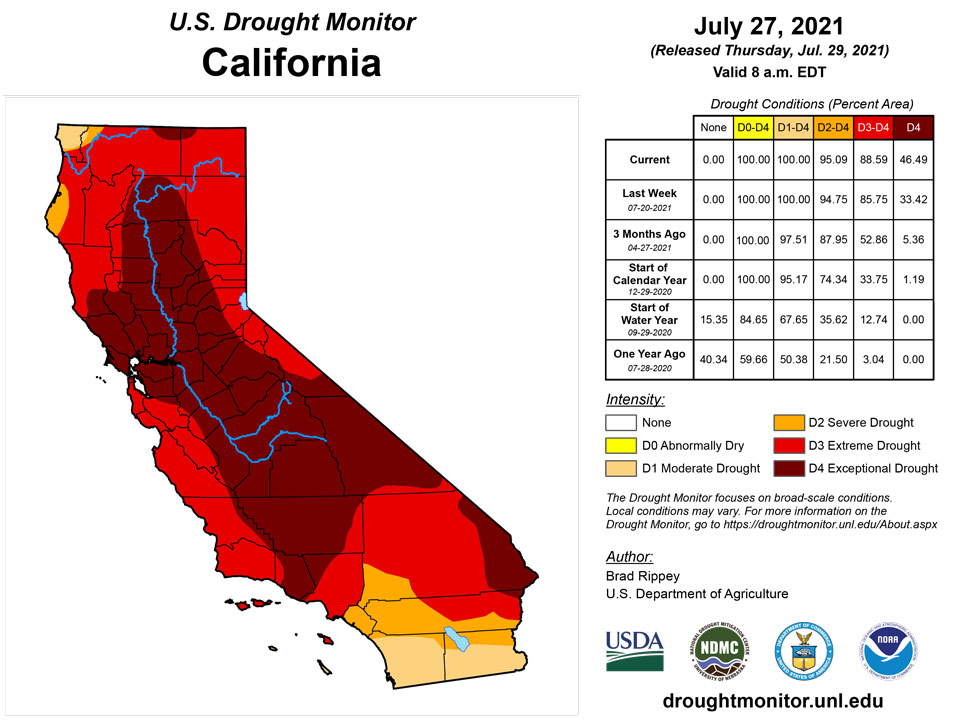
Further expansion of moderate to exceptional drought (D1 to D4) was introduced in parts of California and the Northwest, as agricultural, wildfire, and water-supply impacts continued to mount. Oregon’s third-largest wildfire in modern history, the Bootleg Fire, has burned more than 410,000 acres of timber and brush, but was more than 50% contained. California’s largest active blaze, the Dixie Fire, has scorched nearly 220,000 acres only about 15 miles northeast of the town of Paradise, which was devastated by the Camp Fire in 2018. Washington continued to lead the country in several drought-related agricultural categories, according to the U.S. Department of Agriculture, including topsoil moisture rated very short to short (99% on July 25), as well as very poor to poor ratings for rangeland and pastures (97%) and spring wheat (88%). In addition to Washington, at least two-thirds of the rangeland and pastures were rated very poor to poor on July 25 in Montana (91%), Arizona (82%), Oregon (80%), and Utah (69%). Montana rivaled Washington for agricultural drought severity, with topsoil moisture rated 97% very short to short and a nation-leading 70% of its barley rated very poor to poor. Farther south, however, an active monsoon circulation delivered drought relief in the form of diurnal showers and thunderstorms, some heavy. Up to one category of improvement was introduced in parts of Arizona, New Mexico, southwestern Colorado, and southern sections of Utah and Nevada. In Arizona, Tucson received more rain in 6 days (4.20 inches fell from July 20-25) than during all of 2020, when annual precipitation of 4.17 inches was the lowest on record. Despite the positive effect of monsoonal showers on surface conditions (e.g. improved vegetation health, topsoil moisture, and streamflow), serious long-term, underlying drought persisted, with obvious impacts on groundwater and reservoirs. The surface elevation of Lake Mead, on the Colorado River behind Hoover Dam, fell to a new record low—1,067.59 feet above sea level—on July 23. In Utah, the surface elevation of the Great Salt Lake fell below 4,191.4 feet in late July, breaking the previous record low set in 1963.
Caribbean
In Puerto Rico, abundant showers across interior locations led to the removal of two small patches of dryness (D0), but the drought depiction was unchanged in coastal areas.
Alternating weather conditions occurred across the U.S. Virgin Islands (USVI) during this USDM week (07/21/21-07/27/21). A low-level trough/tropical wave brought showers early in the week, with another tropical wave and a Tropical Upper Tropospheric Trough (TUTT) causing more rain later in the week. Drier and more stable airmasses preceded and followed these systems, along with a Saharan Air Layer, which inhibited showers.
Radar-based estimates of rainfall (QPE) for the 7 days ending at 12z on Tuesday showed widely-varying precipitation amounts, ranging from less than half an inch (over eastern St. Croix) to locally 2 inches or more on all three islands. Satellite-based (IMERG) estimates of 7-day precipitation revealed a large area of 2+ inches of rain that extended from St. John and St. Thomas northward for several hundred miles, with St. Croix having from half an inch to 2 inches in places.
Seven-day rain gauge totals ranged from 1.15 inches to 2.54 inches on St. John, 0.98 to 1.63 inches on St. Thomas, and 0.33 inch to 1.73 inches on St. Croix. The rain improved Standardized Precipitation Index (SPI) values on St. Croix and St. John, but groundwater levels still remain historically low. The groundwater level at the USGS Grade School 3 well on St. Thomas rose in the last few days but was still well below where it was back in December 2020. Groundwater levels on St. John and St. Croix continued to decline, although the rate of decline has slowed in recent days. There was no change in the USDM status this week, with St. Croix continuing at D2-SL, St. John continuing at D1-L, and St. Thomas continuing at D0-L.
Pacific
Parts of interior Alaska received substantial rain, while showers mostly bypassed some locations. As a result, moderate drought (D1) was expanded slightly westward into central Alaska, but some dryness (D0) was eradicated in the east-central portion of the state. Interior Alaska’s largest active wildfire, the Munson Creek Fire, has burned more than 54,000 acres of vegetation.
In Hawaii, there were no changes to the drought depiction, despite an increase in the intensity of showers across windward locations, in part due to moisture associated with the remnants of eastern Pacific Tropical Storm Guillermo. In Hawaiian areas where rainfall has increased, low streamflow values were being monitored to gauge the impact of the shower activity.
The weather features across the U.S.-Affiliated Pacific Islands (USAPI) during this USDM week (07/21/21-07/27/21) included an expansive monsoon flow across western Micronesia. Tropical Storm Nepartak (11W) formed north of the Marianas at mid-week and helped intensify a monsoon trough west and north of the Marianas. The convergent monsoon flow drenched the Marianas with several inches of rain. Weekly totals ranged from 2.50 inches in the south at Guam to over 5 inches at Rota (5.77 inches) and the Saipan IAP (6.12), with over 8 inches estimated from satellite over the far northern Marianas. Over eastern Micronesia, the trade-wind pattern fell apart, with only weak circulations, disturbances, and surface troughs bringing areas of rain. South of the equator, easterly winds brought a few showers to American Samoa, but the weather for the week was mostly dominated by dry high pressure.
Satellite-based estimates of 7-day precipitation (QPE) are available from two products: one using mainly infrared (IR) sensors (NESDIS GOES-R AHI) and the other incorporating microwave sensors (GPM IMERG). These QPE products showed a huge arch of 4+ inches of rain that stretched in the shape of a U from the northern Chinese coast, to the Marianas, then northeastward, associated with the monsoon trough and TS Nepartak. A patchy band of 1+ inches stretched eastward across Palau, the Federated States of Micronesia (FSM), and the southern Marshall Islands (RMI). The satellite QPE detected only a few tenths of an inch of rain over American Samoa.
As noted earlier, it was a wet week in the Marianas, with rainfall totals consistently over 2 inches (one inch is the weekly minimum needed to meet most water needs in the Marianas), so D-Nothing continued. Further south, the monsoon rains delivered weekly precipitation totals (based on rain gauge amounts received for the week) over 2 inches to Woleai (3.41 inches) and Yap (2.56), but under 2 inches to Ulithi (1.20 inches with 3 days missing). In Palau, Airai recorded 1.71 inches and the Koror COOP station 0.94 inch. Rain earlier in the month resulted in July month-to-date totals at these stations that were above the monthly minimum needed to meet most water needs. Kosrae (3.28 inches) and Nukuoro (3.94 inches) were wet (above the weekly minimum) while the rest of the FSM stations were dry, with values ranging from 0.23 inch at Lukunor to 1.83 inches at Kapingamarangi. Except for Lukunor, the month-to-date totals were above the monthly minimum at the FSM stations. D-Nothing continued at Palau and the FSM stations except for Fananu, which was not analyzed due to no data.
It was a dry week in American Samoa, with Pago Pago recording 0.37 inch and the automated stations at Siufaga Ridge (0.73 inch) and Toa Ridge (0.28 inch) below an inch (the automated stations had one day missing). But month-to-date totals were wet, so D-Nothing continued at Tutuila.
In the RMI, Kwajalein was wet (above the 2-inch weekly minimum) with 2.31 inches of rain for the week. But the rest of the stations were dry, with weekly rainfall totals ranging from 0.40 inch at Jaluit to 1.50 inches at Majuro. Ailinglaplap recorded 0.55 inch for the week and 2.43 inches so far this month. This week marked the fourth consecutive dry week, and July 2021 (based on data received so far in the month) marked the third consecutive dry month. Compared to historical full Julys, July 2021 was the driest July in the 37-year record, June-July 2021 was the driest such 2-month period, and May-July 2021 was the driest May-July. Jaluit reported 0.40 inch of rain for the week and 3.22 inches so far this month. This week marked the seventh consecutive dry week. Compared to historical full Julys, July 2021 ranked as the second driest July in 38 years of data, June-July 2021 was the fourth driest June-July, and May-July 2021 was the ninth driest such 3-month period. D0-S continued at Ailinglaplap and Jaluit. At the other RMI stations, either July-to-date has been wet (Kwajalein and Mili), or previous weeks have been wet, so D-Nothing continued. Of concern is the declining reservoir level at Majuro; as of July 26, about 27 million gallons were in the reservoir, which is below the threshold for concern of 28.8 million gallons. The drought status at Utirik could not be analyzed due to lack of data.
Looking Ahead
Cooler air will overspread the northern Plains and upper Midwest, though many drought-affected areas will remain in need of moisture. Large sections of the central and southern Plains will also remain mostly dry, accompanied by some of the hottest weather of the summer. Farther east, periodic showers and thunderstorms will affect the Great Lakes and Northeastern States. Meanwhile, hot, humid weather will linger into the weekend across the South, where an approaching cold front will generate showers and thunderstorms. Elsewhere, the Southwestern monsoon circulation will remain active, with beneficial showers dampening interior sections of the western United States as far north as Wyoming and southern Idaho.
The NWS 6- to 10-day outlook for August 3 – 7 calls for the likelihood of above-normal temperatures in Alaska, southern Florida and from the Pacific Coast to the northern Plains and upper Midwest, while cooler-than-normal conditions will cover much of the southeastern half of the country. Meanwhile, near- or below-normal rainfall across most of the United States should contrast with wetter-than-normal weather in a few areas, including western Alaska, the southern Atlantic region, the southern Plains, and the Northwest.
Author(s):
Brad Rippey, U.S. Department of Agriculture
Richard Heim, NOAA/NCEI
Dryness Categories
D0 Abnormally Dry—used for areas showing dryness but not yet in drought, or for areas recovering from drought.
Drought Intensity Categories
D1 Moderate Drought
D2 Severe Drought
D3 Extreme Drought
D4 Exceptional Drought
Drought or Dryness Types
S Short-term, typically less than 6 months (agriculture, grasslands)
L Long-term, typically more than 6 months (hydrology, ecology)
SL Area contains both short- and long-term impacts
Source: National Drought Mitigation Center
