


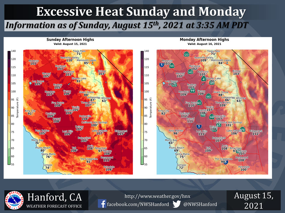
Mariposa projected high temperature for Sunday: 101 degrees, Monday: 102 degrees
Oakhurst projected high temperature for Sunday: 103 degrees, Monday: 105 degrees
Yosemite Valley projected high temperature for Sunday: 110 degrees, Monday: 109 degrees
August 15, 2021 - The National Weather Service Hanford Office reports maximum temperatures of 105 degrees or higher are likely in the San Joaquin Valley, Kern County desert, and Coastal Range Sunday afternoon and Monday afternoon.
Reduce time outdoors, drink plenty of water, and remain in an air-conditioned building.
A downward temperature trend will begin Tuesday.
  Area Forecast Discussion
  National Weather Service Hanford CA
  339 AM PDT Sun Aug 15 2021

  .SYNOPSIS...
  Isolated thunderstorms are possible in the Sierra Nevada each
  afternoon today and Monday. Excessive heat is expected in the San
  Joaquin Valley, Kern County desert, and Coastal Range today and
  Monday. A downward temperature trend will begin Tuesday. High
  temperatures Wednesday afternoon and Thursday afternoon will be
  near normal for this time of year. Gradual warming trend with dry
  conditions are expected through the remainder of next week.

  &&

  .DISCUSSION...
  A large dome of high pressure sitting over us is providing above
  normal temperatures. Easterly flow is bringing in sub tropical
  moisture into the region that has been providing afternoon and
  evening thunderstorms across parts of the Sierra.

  500mb Heights are expected to remain around 2 standard deviations
  above normal and will not provide record temepratures, but will be
  very hot for this time of year. NBM is forecasting a record high
  min temperature of 83 at BFL on Monday morning, so we will be
  keeping an eye on this. No significant anomalies in PWATs for the
  sub tropical moisture feeding in from the east, so we are not
  expecting any flooding concerns across the Sierra today. Weak
  easterly wave is forecast move through SOCAL in association with
  an upper level low center off the central coast of Baja today.
  High pressure center will sit over us on Monday with some strong
  mid level WAA in advance of a trough that will be pushing through
  the PACNW. This will make Monday the hottest day of the event, but
  not record breaking...but very close. FAT record high on Monday
  is 112 set last year and we are forecasting a high of 109. BFL
  record high on Monday is 109 set in 1920 and we are forecasting a
  high of 107.

  Now for the good news...it will start to cool down rather quickly
  as a trough of low pressure will swing through the region on
  Tuesday. This will bring cooler temps and break down the "Dome of
  Heat" that has been cooking us for the past several days. We will
  see temps drop below 100 by Wednesday in the SJV. This will be
  the first day since August 6th for both FAT and BFL. We will stay
  there through the remainder of the week and into the weekend.
  With strong SW flow, the Sierra convection will be blown off to
  the east and keep the Sierra void of afternoon convection from
  Tuesday on. Stay hydrated and cool over the next couple of days
  with the extreme heat.

  &&

  .AVIATION...
  In the Sierra Nevada, areas of MVFR and local mountain obscuring
  IFR in showers and isolated thunderstorms from 20z today until
  03Z Monday. Elsewhere, VFR conditions will prevail across the
  remainder of Central California through at least the next 24
  hours.

  &&

  .AIR QUALITY ISSUES...
  On Sunday August 15 2021... Unhealthy for sensitive groups in Kern
  and Tulare Counties.
  Further information is available at Valleyair.org
Source: NWS
