


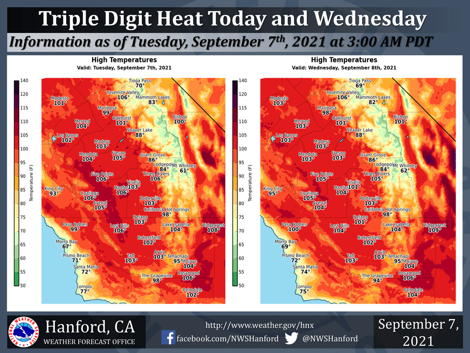
Mariposa projected high temperature for Tuesday/Wednesday: 99 degrees, 98 Degrees
Oakhurst projected high temperature for Tuesday/Wednesday: 101 degrees
Yosemite Valley projected high temperature for Tuesday/Wednesday: 106 degrees
September 7, 2021 - The National Weather Service Hanford Office reports widespread triple digit heat is expected in the San Joaquin Valley, Kern County desert, and Coastal Range this afternoon and Wednesday afternoon.Heat-sensitive groups, such as the elderly, young children, and those with chronic ailments may need assistance to avoid heat-related illness.
  Area Forecast Discussion
  National Weather Service Hanford CA
  209 AM PDT Tue Sep 7 2021


  .SYNOPSIS...
  Dry and unseasonably hot conditions will continue into the middle
  of the week. Temperatures will trend slowly downward after
  Thursday, and highs are expected to be near normal for this time
  of year by the start of next week. Moisture moving in from the
  south will bring a chance for some thunderstorms in the Sierra
  Nevada and the Tehachapi Mountains Thursday and Friday.

  &&

  .DISCUSSION...
  A strong ridge of high pressure will remain centered over the
  Great Basin and will bring a stretch of hot temperatures to much
  of Central California, including triple digit heat in the San
  Joaquin Valley, the West Side Hills, and the Kern County desert.
  Daytime highs will likely reach around 105 degrees in the Central
  Valley and much of the Kern County desert, except near 110 degrees
  towards China Lake for today. The ridge will remain in place for
  at least the next few days, so high temperatures will run steady,
  though perhaps a degree or two lower, on Wednesday and Thursday
  with warm overnight lows. The probability of high temperatures at
  or above 105 degrees is highest for today in the Central Valley,
  or up to around 45 percent. As for the Kern County desert,
  probabilities range anywhere from 60 percent to near 100 percent
  for a high of at least 105 degrees today and Wednesday and around
  80 percent for a high of 108 degrees or higher at China Lake.
  In short, heat will be the main concern over the next few days.

  Later this week, there remains the possibility of isolated
  thunderstorms in the mountains, including from Yosemite to the
  Tehachapi Mountains. It appears moisture is rather limited, so dry
  thunderstorms are more likely. In addition, model guidance has
  been trending lower in terms of available moisture, including over
  the Desert Southwest, for Thursday into Friday. It appears the
  high pressure may be a bit too strong and could result in little
  instability, other than daytime heating. The upper-level high
  will shift southeastward towards the Four Corners, so a gradual
  lowering in 500 mb/hPa heights will occur over Central CA while
  daytime highs start to lower after Thursday.

  For the weekend into early next week, temperatures will continue
  to trend downward a bit as the ridge weakens; however, above
  average temperatures will persist with highs returning to the
  mid to upper-90s. At least, triple digits are expected to take a
  break for most of the region during this period. In addition,
  expect dry weather to return for Saturday through at least next
  Tuesday.

  &&


  .AVIATION...
  In the Sierra Nevada and Kern County mountains, areas of MVFR
  visibilities, with local mountain obscured IFR visibilities, are
  expected due to smoke and haze near active wildfires through at
  least the next 24 hours. In the San Joaquin Valley, MVFR
  visibilities are likely at times due to haze.

  &&

  .AIR QUALITY ISSUES...
  On Tuesday September 7 2021... Unhealthy for sensitive groups in
  Fresno... Kern... Kings... Madera and Tulare Counties and Sequoia
  National Park and Forest.
  Further information is available at Valleyair.org
Source: NWS
