


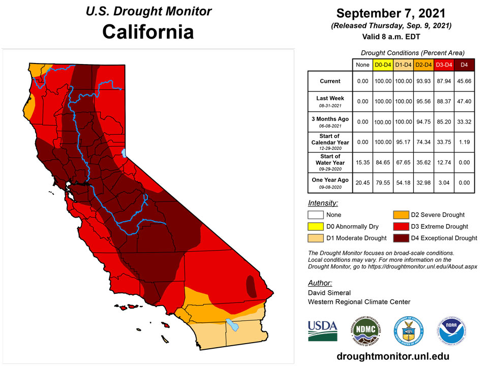
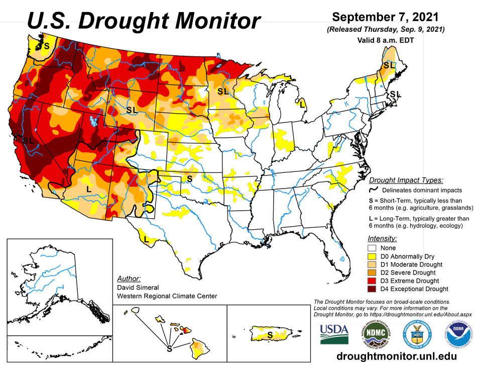
California and National Drought Summary for September 7, 2021
Summary
September 9, 2021 - This U.S. Drought Monitor (USDM) week saw continued improvement in conditions across drought-stricken areas of the Central and Northern Plains states as well as in Iowa and Minnesota where light-to-moderate rainfall accumulations were observed. Despite recent precipitation in the Northern Plains, hay shortages and the associated costs of purchasing and transporting supplemental feed are forcing some ranchers to sell livestock. In response to the emerging situation, the U.S. Department of Agriculture (USDA) announced expansion of emergency assistance through the ELAP program to help cover feed transportation costs for drought-impacted ranchers. In the Northeast, the remnants of Hurricane Ida brought intense, heavy rains (5 to 10+ inches) and devastating flooding to areas of Pennsylvania, New Jersey, New York, and Connecticut. In the Southeast, short-term dryness (past 30- to 60-day period) and declining soil moisture and streamflow levels led to degradation on the map in portions of the Carolinas. In the South, short-term precipitation shortfalls and declining soil moisture levels led to some degradation of conditions in areas of Arkansas and Oklahoma that have largely missed out on recent rainfall events. Out West, dry conditions prevailed across most of the region this week. However, some beneficial rainfall was observed across isolated areas of the Southwest in association with the remnants of Hurricane Nora.
Northeast
In the region, the big story of the week was the record-breaking rainfall and devastating flooding caused by the remnants of Hurricane Ida. The hardest hit areas (Connecticut, New Jersey, New York, Pennsylvania) received rainfall accumulations ranging from 5 to 10+ inches—leading to widespread flooding, paralyzing transportation, and stranding residents amongst the floodwaters. On the map, the associated heavy rainfall led to improvements in drought-related conditions in Cape Cod, where 2 to 6+ inch accumulations were observed. In Maine, 1-to-3-inch accumulations this week provided a slight boost in streamflows in northeastern Maine and improved areas of Moderate Drought (D1). Average temperatures for the week were cooler than normal across the region with departures ranging from 1 to 4 deg F below normal.
Southeast
During the past week, light to moderate rainfall accumulations (1 to 3 inches) were observed across isolated areas of Georgia, the Carolinas, and Virginia while heavier rains (2 to 5 inches) fell across areas of Alabama and Florida. During the past 30 to 60-day period, precipitation has been slightly below normal across areas of southern Virginia, North Carolina, and South Carolina, leading to the introduction of areas of Abnormally Dry (D0). In Coastal Plain areas and Piedmont regions of North Carolina, USGS stream gauges are reporting below-normal flows. Average temperatures for the week were mainly below normal (1 to 5 deg F), except for areas of eastern Florida and extreme southern Alabama where temperatures were slightly above normal.
South
After the passing of Hurricane Ida, the region experienced some drying out this week as compared to the previous week’s deluge. For the past 30-day period, above-normal precipitation levels (130 to 300% of normal) have been observed across southeastern Louisiana, Mississippi, and much of Tennessee. Conversely, precipitation has been below normal across much of Arkansas, Texas, and Oklahoma during the past month, leading to expansion of areas of Abnormally Dry (D0). This includes around Tulsa, Oklahoma, which observed only 0.85 inches (normal 3.64 inches) for the month of August and no precipitation to date for September. Elsewhere, some minor improvements were made in an area of Moderate Drought (D1) in the Trans-Pecos region in the vicinity of Big Bend National Park where the Chisos Basin observing station reported 10.42 inches of rain (340% of normal) for the month of August. Likewise, the Pine Springs Guadalupe National Park observing station in the Trans-Pecos logged 8.98 inches (560% of normal) during August 2021. For the week, average temperatures were above normal (3 to 9 deg F) across Texas, Oklahoma, and western portions of Louisiana and Arkansas while areas to the east were 1 to 6 deg F below normal.
Midwest
On this week’s map, widespread one-category improvements were made in drought-stricken areas in northern Iowa and western Minnesota, which received another round of beneficial precipitation this week. In these areas rainfall accumulations ranged from 1 to 4 inches. In areas of northern Iowa and southern Minnesota, percentage of normal precipitation has ranged from 150% to 300% of normal for the last 30-day period. Likewise, light rainfall this week led to trimming back of small areas of Moderate Drought (D1) in northwestern Illinois and west-central Indiana. Conversely, dry conditions during the past 90-day period led to slight expansion of areas of Severe Drought (D2) in northern Wisconsin as well as areas of Moderate Drought (D1) in Upper Peninsula Michigan.
High Plains
On this week’s map, areas of the region—including eastern portions of North Dakota, South Dakota, Nebraska, and Kansas—saw isolated improvements in response to continued rainfall activity. The heaviest rainfall in the region was observed in eastern Kansas where accumulations ranged from 2 to 7 inches, while areas further to the north in Nebraska and the Dakotas received 1-to-4-inch accumulations in isolated areas. For the last 30-day period, the percentage of normal precipitation has ranged from 100 to 300% of normal across a widespread area of the Central and Northern Plains. However, isolated pockets of dryness have persisted—particularly in western portions of the region that have not benefited from the recent rainfall events. According to the USDA for the week ending September 5, the percentage of topsoil in North Dakota rated short to very short was 63%, while neighboring South Dakota was rated 66% short to very short.
West
For the week, most of the region continued to experience dry conditions, although some residual moisture from Hurricane Nora worked its way into the Southwest leading to some isolated shower activity. On this week’s map, improvements were made in isolated areas of Arizona, New Mexico, and Utah where recent monsoonal rainfall has continued to improve drought conditions on a shorter-term basis. For the monsoon season (to date), some impressive rainfall totals have been observed in areas of southern and central Arizona and New Mexico as well as in areas of Utah. In Arizona, Tucson is currently having its 3rd wettest monsoon season on record with 12.41 inches (as of September 7), Flagstaff 10.35 inches (4th wettest), Payson 13.06 inches (2nd wettest), and Las Cruces, New Mexico 5.06 inches (3rd wettest). Elsewhere in the region, much of California, western Great Basin, Pacific Northwest, and the Northern Rockies have experienced drier-than-normal conditions during the past 90-day period. In Washington, drought and associated precipitation deficits dating back to the springtime, combined with extreme summer heat, have severely impacted the state’s wheat crop which is reportedly had its lowest output since 1973. According to the USDA, the percentage of topsoil rated short to very is as follows: Washington 100%, Oregon 89%, Idaho 75%, Montana 93%, Wyoming 70%, and California 85%. According to the Natural Resources Conservation Service (Sept 1), reservoir storage levels were below normal across all the western states except for Washington state (data not yet available for Montana).
Caribbean
In Puerto Rico, 7-day rainfall accumulations of 1 to 5 inches were observed along the western portion of the Cordillera Central. On the map, areas of Moderate Drought (D1) and Abnormally Dry (D0) expanded across the island where precipitation deficits in the southern and eastern parts of the island were ranging from 4 to 12+ inches. Additionally, the majority of USGS stream gauges across the island are reporting streamflows falling below the 10th percentile as well as satellite-based soil moisture measurements showing below-normal levels.
The Virgin Islands saw an increase in rainfall during the first half of August, when 3 to 4 inches fell, primarily from Hurricane Grace. Since then, very little rain has fallen. St. Thomas observed just under one-half inch during the last 3 weeks. In sum, August brought a near-normal 4.35 inches of rain to St. Thomas, on the heels of a wet June and a July that was just slightly drier than normal. As a result, St. Thomas remained free from impactful dryness.
On the other hand, St. John and St. Croix recorded a mere 0.07 inches and 0.25 inches, respectively, since mid-August, with the month as a whole dropping 3.9 inches of rain on Windswept Beach in St. John and 3.27 inches on Rohlsen Airport on St. Croix. The first 8 months of this year, Windswept Beach received 19.55 inches of rain – about 6 inches less than normal. January – August 2021 was the seventh driest such period in 38 years of record. Rohlsen Airport on St. Croix has only accumulated about two-thirds of normal for the same period.
Looking at the big picture, moisture deficits seem sufficient to keep D1 on St. Croix, and to increase the designation to D1 on St. John. Since deficits exist in both the short-term (3 weeks) and the long-term (8 or more months) time scales, the D0(L) and D1(L) from last week were changed to D1(SL) at both locations.
Pacific
In the Hawaiian Islands, light rainfall (~1 inch) was observed along areas of both the windward and leeward sides of the Big Island as well as on Oahu, whereas Maui, Molokai, and Lanai were dry. The only change on this week’s map was a one-category improvement in areas of Abnormally Dry (D0) along the Koolau Range of Oahu where streamflows are running in the normal-to-above normal range and August rainfall was near-normal to above average. On Maui, despite some moisture from the remnants of Tropical Cyclone Linda, drought conditions persisted with the Farm Service Agency reporting some cattle mortality in southeast Maui due to the drought.
In Alaska, generally dry conditions prevailed during the past week across most of the state. However, some moderate precipitation accumulations (ranging from 2 to 4 inches) were observed in areas of Southeast Alaska as well as on Kodiak Island. In Southeast Alaska, Ketchikan has already received 5.78 inches (normal for the month is 3.25 inches) as of September 7. For August, above-normal precipitation was observed across areas of the state including Anchorage (4.34 inches, 9th wettest), Fairbanks (3.67 inches, 9th wettest), and Juneau (8.62 inches, 10th wettest).
No abnormal dryness or drought is affecting Palau. Koror reported 13.36 inches of rain for the month of August 2021. This was the third consecutive month of subnormal rainfall. For June through August, Koror reported 36.78 inches compared to a normal of 50.05 inches Though below normal, this was sufficient to prevent any abnormal dryness. In addition, Koror recorded over 42 inches of rainfall in the prior two months. Also, the first week of September brought Koror almost 2 inches of rain, further preventing any developing dryness.
The Mariana Islands also remain free of notable dryness. Guam accumulated 15.44 inches of rain in August, Rota Airport 13.96 inches, and Saipan 10.95 inches At both Saipan and Rota, over 95 percent of normal rain has fallen in two of the 3-month June – August 2021 period. Guam, however, experienced its third consecutive month with subnormal rainfall, totaling 29.28 inches while the normal is 36.38 inches Although below normal, enough rain has fallen to prevent any significant impacts.
Across the Federated States of Micronesia, abnormal dryness (D0) was removed from Chuuk Lagoon, leaving only Kapingamarangi at D0 while the rest of the islands are free from any problematic moisture shortages. Chuuk Lagoon reported 6.20 inches in August, which is only about half of normal; however, this is sufficient to meet their needs, especially since over 130 percent of normal amounts fell in July.
Much of the rest of Micronesia followed a similar pattern, with locations north of Kapingamarangi reporting 54 to 84 percent of normal for August following a wetter-than-normal July. Pingelap, Kosrae, and Woleai recorded 54 to 64 percent of normal August rainfall following a July with 125 to 154 percent of normal. and Yap were exceptions, reporting their second and third consecutive month of drier-than-normal conditions, respectively. The July – August total at Pohnpei was 23.64 inches, considerably lower than the normal of 38.08 inches Meanwhile, June – August precipitation in Yap was 33.32 inches, about 10 inches below normal. In both cases, rainfall totals were enough to keep any impactful dryness at bay. Also, the first week of September featured significant precipitation in general, with Yap, Kosrae, and Lukunor receiving between 3.9 to 4.9 inches of rain.
Kapingamarangi, in the southern reaches of Micronesia, is the only location in experiencing any degree of notable dryness there. Only 4.36 inches of rain fell in August – about 40 percent of normal. Still, rainfall for the past 5 months totaled over 64 inches, which is a few inches above normal. The remaining D0 largely represents lingering effects from the severe May 2020 – March 2021 dry spell, when they measured only about 41 percent of the normal 116 inches for the period.
At the end of August, D0 to D1 conditions covered the Marshall Islands outside Majuro and Mili Atoll in the southeastern reaches of the island chain This week, D0 was removed from both Jaluit and Wotje. Over 3 inches of rain this past week eased dryness in Jaluit. Wotje missed out on rain during the first week of September, but August rainfall of 6.72 inches pushed their 2-month total to 11.88 inches – almost 2.5 inches above normal. August was the wettest month at Wotje since November 2020.
In sharp contrast, Ailinglaplap (in the center of the Marshall Islands) saw moisture deficits increase, prompting a deterioration to D2 this week. This is the driest designation anywhere in the U.S. Affiliated Pacific Islands. No rain fell the first week of September, and their August total of 2.82 inches brought their May – August accumulation to just under 15 inches – well short of their 43.88 inches normal for the period. Typically, rainfall would be on the increase following the relatively-dry December – April period. This year, March and April combined to bring over 35 inches of rain to Ailinglaplap, followed by 4 starkly dry months, which has continued into September.
Pago Pago in American Samoa recorded 7.82 inches of rain in August. Two of the past 3 months brought significantly above normal precipitation here, and the region remains free of dryness concerns.
Looking Ahead
The NWS WPC 7-Day Quantitative Precipitation Forecast (QPF) calls for moderate-to-heavy rainfall accumulations ranging from 2 to 5+ inches along the Gulf Coast of Texas, Louisiana, Florida Panhandle, and areas of southern Georgia. Across the Mid-Atlantic and the Northeast, light rainfall accumulations (generally < 1 inch) are expected; except for coastal areas of Massachusetts and Maine where accumulations of approximately 2 inches are predicted. In the Midwest, light precipitation accumulations (generally < 1 inch) are forecasted across the eastern half of the region, while areas in the western extent will be drier over the coming week. From the Plains to the West Coast, mainly dry conditions will prevail with the exception of areas of isolated, light precipitation possible across the Central and Southern Rockies and the northern Great Basin, while slightly greater accumulations (generally around 1 inch) are expected in the Northern Rockies. The CPC 6-10-day Outlooks are for a moderate-to-high probability of above-normal temperatures across the northern half of the conterminous United States as well as along the Eastern Seaboard extending into New England. Across much of the Pacific Northwest, North Dakota, and the Upper Midwest, normal temperatures are expected. In terms of precipitation, there is a low-to-moderate probability of above-normal precipitation across New England, the Midwest, the South, and the eastern half of Texas. Below-normal precipitation is expected across most of the Western U.S.
Author(s):
David Simeral, Western Regional Climate Center
Richard Tinker, NOAA/NWS/NCEP/CPC
Dryness Categories
D0 Abnormally Dry—used for areas showing dryness but not yet in drought, or for areas recovering from drought.
Drought Intensity Categories
D1 Moderate Drought
D2 Severe Drought
D3 Extreme Drought
D4 Exceptional Drought
Drought or Dryness Types
S Short-term, typically less than 6 months (agriculture, grasslands)
L Long-term, typically more than 6 months (hydrology, ecology)
SL Area contains both short- and long-term impacts
Source: National Drought Mitigation Center
