


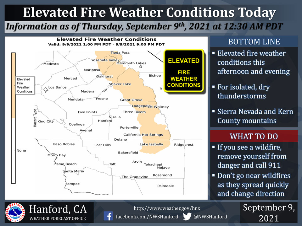
September 9, 2021 - The National Weather Service Hanford Office reports isolated, dry thunderstorms are possible in the Sierra Nevada and Kern County mountains this afternoon and this evening.
Dry thunderstorms are thunderstorms that produce little or no precipitation at the surface.
Cloud to ground lightning strikes could ignite new wildfires in the Sierra Nevada and Kern County mountains this afternoon and this evening.
Any wildfires that develop will likely spread quickly.
  Area Forecast Discussion
  National Weather Service Hanford CA
  137 AM PDT Thu Sep 9 2021

  .SYNOPSIS...
  Widespread triple digit heat is expected in the San Joaqin Valley,
  Coastal Hills, and Kern River Valley this afternoon. Isolated, dry
  thunderstorms are possible in the Sierra Nevada and Kern County
  mountains this afternoon into this evening. A downward temperature
  trend is anticipated Friday and Saturday. High temperatures will
  be two to four degrees above normal Sunday through Wednesday.

  &&

  .DISCUSSION...
  An upper-level area of high pressure will be centered near the
  Four Corners of the United States today. Some subtropical moisture
  from the Baja Peninsula will progress northward along the western
  periphery of this anticyclone this afternoon. This bit of moisture
  influx coupled with orographic forcing will be responsible for the
  possibility of isolated, dry thunderstorms in the Sierra Nevada
  and Kern County mountains this afternoon into this evening. Dry
  thunderstorms can ignite new wildfires with lightning, but will
  not produce much rain to put the wildfires out. Widespread,
  triple digit heat is anticipated in the San Joaquin Valley,
  Coastal Hills, and Kern River Valley this afternoon. Triple digit
  heat probabilities in Bakersfield are 91%, Fresno 86%, Hanford
  81%, Merced 69%, and Visalia 66% this afternoon.

  An Eastern Pacific trough of low pressure will approach the
  northwest coast of the United States tonight. This trough of low
  pressure will move eastward across the Pacific Northwest Friday. A
  few dry thunderstorms cannot be ruled out Friday afternoon in the
  Sierra Nevada from Fresno County northward. A ridge of high
  pressure will extend westward across Southern California Friday
  night through Saturday night. A downward temperature trend is
  expected Friday and Saturday. An Eastern Pacific trough of low
  pressure will approach the northern coast of California Sunday.
  This trough of low pressure will move eastward through Northern
  California Sunday night. Cyclonic flow aloft is expected early
  next week. High temperatures Sunday afternoon through Wednesday
  afternoon will be two to four degrees above their typical values
  for the first half of September.

  &&

  .AVIATION...
  In the Sierra Nevada and Kern County mountains, areas of MVFR
  visibilities, with local mountain obscured IFR visibilities, are
  expected due to smoke and haze near active wildfires through at
  least the next 24 hours. In the San Joaquin Valley, intermittent
  MVFR visibilities are likely due to haze.

  &&

  .AIR QUALITY ISSUES...
  On Thursday, September 9th, 2021, unhealthy for sensitive groups
  in Fresno, Kern, and Tulare Counties, as well as in Sequoia
  National Park and Forest. Further information is available at
  Valleyair.org.
Source: NWS
