


Note: Click here for Sequoia National Park KNP Complex Wildfires Updates for Wednesday
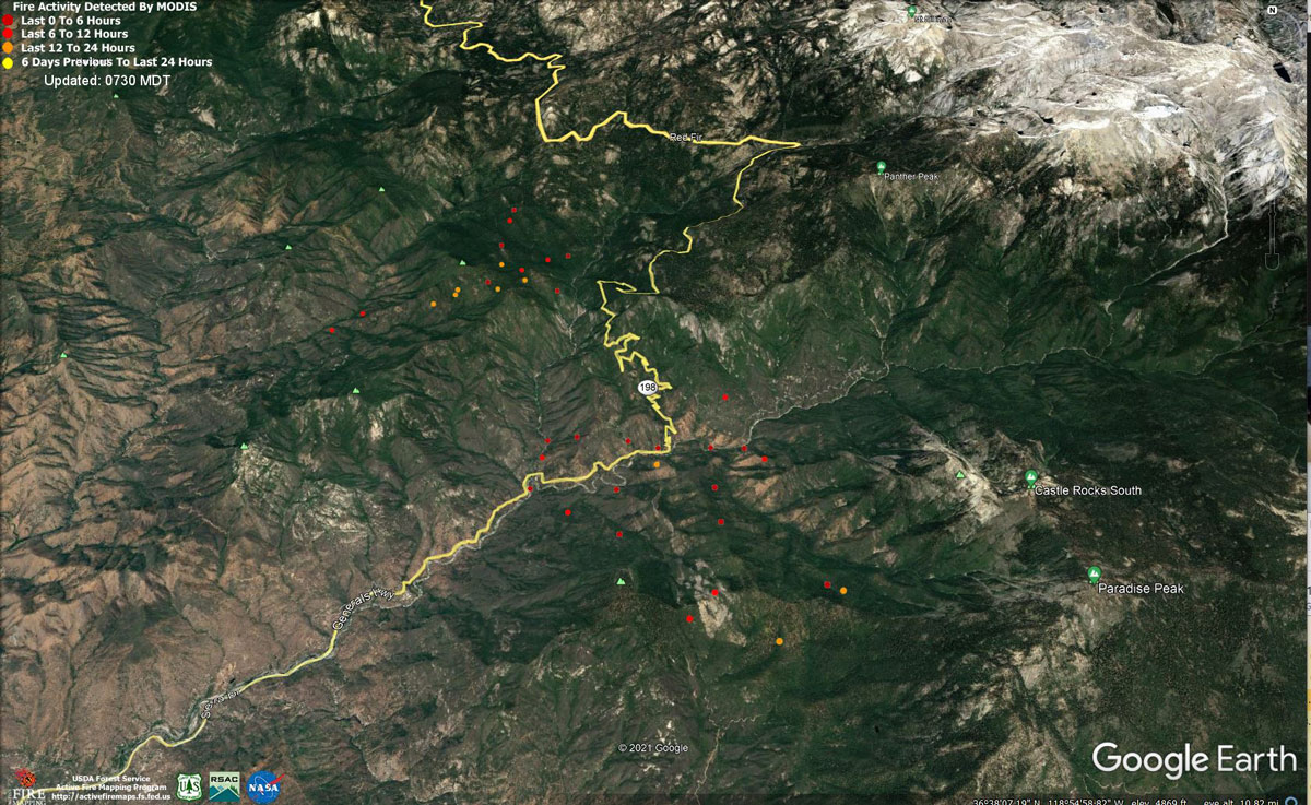
MODIS map of the KNP Complex of Wildfires on Tuesday morning at 6:30 A.M.
Note: 1,200 Pixels Wide - Note: Older Yellow not shown
MODIS Active Fire Mapping Program Frequently Asked Questions
Note: Click here for Sequoia National Park KNP Complex Wildfires Updates for Wednesday
Update: Evening Video
Evening Update: KNP Complex Fire for Tuesday Evening, 5,861 acres, now with 300 personnel.
Basic Information
| Current as of | 9/14/2021, 6:46:55 PM |
| Incident Type | Wildfire |
| Cause | Lightning |
| Date of Origin | Friday September 10th, 2021 approx. 07:00 AM |
| Location | Sequoia National Park |
| Incident Commander | Leif Mathieson |
| Coordinates | 36.567 latitude, -118.811 longitude |
Current Situation
| Total Personnel | 300 |
| Size | 5,861 Acres |
| Fuels Involved |
Timber, Chaparral |
| Significant Events |
Observed fire activity: Flanking, backing, rolling out, uphill runs. Paradise Fire has crossed the Generals Highway near Potwisha Campground. |
Outlook
| Planned Actions |
Use aviation resources to moderate fire behavior while available hand crews look for opportunities for direct and indirect line construction. Prevent fire from crossing major drainages. Prepare infrastructure for arrival of fire and provide protection during fire passage. |
| Projected Incident Activity |
12 hours: Colony fire backs off ridgetop. Paradise fire rolls out to north and runs upslope to the south. 24 hours: Colony fire backs off ridgetop, slope reversal results in uphill runs to north and east towards Giant Forest and Lodgepole. Paradise fire rolls out to north and runs upslope to the south, slope reversal results in uphill runs to north and east towards Giant Forest. 48 hours: Colony fire backs off ridgetop in all directions. Paradise fire rolls out to north and slope reversal results in uphill runs to north and east towards Giant Forest while fire runs upslope to ridgetop to the south. 72 hours: Colony fire spreads through Yucca Creek and Marble Fork Kaweah drainages. Paradise fire spreads through the Middle and East Fork Kaweah drainages. Anticipated after 72 hours: Colony fire spreads through Yucca Creek and Marble Fork Kaweah drainages. Paradise fire spreads through the Middle and East Fork Kaweah drainages. |
Current Weather
| Weather Concerns |
A dry onshore flow will maintain dry conditions over the fire through the week. Afternoon highs will remain a few degrees above seasonal average over the fire through the middle of the week. A cooling trend will take place beginning on Thursday and continue through next weekend. Good ventilation will favor fire growth. Westerly afternoon and evening winds of 15 to 25 mph with gusts to 40 mph will continue to surface over the wind prone mountain and desert areas through the middle of this week. |
Update: EVACUATION ORDERS for Portions of Three Rivers
Tulare County Sheriff issues an EVACUATION ORDERS for a portion of Three Rivers. The Orders cover Mineral King Drive up to the Sequoia National Park Boundary, including associated structures along both sides of HWY 198 to the Park Boundary. The orders include Oak Grove Bridge down to HWY 198, including Sierra King Dr, Crest Lane, Hammond Dr, Oak Grove Dr., NOT including Dinely Dr.
There are Evacuation WARNINGS for all structures from Old Three Rivers Rd and Blossom Dr to South Fork Dr, including South Fork Dr up HWY 198 to Mineral King Dr, including North Fork Dr, also including all side roads along HWY 198 to Mineral King Dr.
CURRENT EVACUATION ORDERS:
- Silver City and Cabin Cove area on Mineral King Road
- Community of Sycamore within the Sequoia National Park
Three Rivers: Mineral King Drive up to the Sequoia National Park Boundary, including associated structures along both sides of HWY 198 to the Park Boundary. Including, Oak Grove Bridge down to HWY 198, including Sierra King Dr, Crest Lane, Hammond Dr, Oak Grove Dr.
NOT including Dinely Dr.
CURRENT EVACUATION WARNINGS:
Three Rivers: All structures from Old Three Rivers Rd and Blossom Dr to South Fork Dr, including South Fork Dr up HWY 198 to Mineral King Dr, including North Fork Dr, also including all side roads along HWY 198 to Mineral King Dr.
Update: Per Tulare County Sheriff, the mandatory evacuation order has expanded to include the following areas of Three Rivers:
- All of Mineral King Road, from the intersection with Highway 198 to the end of the road
- Areas along Sierra King Drive, Crest Lane, Hammond Drive, and Oak Grove Drive
- Areas along Highway 198 from the intersection with Mineral King Road to the Sequoia National Park entrance station
An evacuation WARNING remains in place in Three Rivers between the intersection of Highway 198 and North Fork Drive and the intersection of Mineral King Road and North Fork Drive.
All employee housing in Sequoia National Park is also under mandatory evacuation. Kings Canyon National Park is still open at this time.
Afternoon Update: KNP Complex Fire for Tuesday Afternoon, 5,861 acres with 130 personnel.
Basic Information
| Current as of | 9/14/2021, 1:21:50 PM |
| Incident Type | Wildfire |
| Cause | Lightning |
| Date of Origin | Friday September 10th, 2021 approx. 07:00 AM |
| Location | Sequoia National Park |
| Incident Commander | Leif Mathieson |
| Coordinates | 36.567 latitude, -118.811 longitude |
Current Situation
| Total Personnel | 130 |
| Size | 5,861 Acres |
| Fuels Involved |
Timber, Chaparral |
| Significant Events |
Observed fire activity: Flanking, backing, rolling out, uphill runs. Paradise Fire has crossed the Generals Highway near Potwisha Campground. |
Outlook
| Planned Actions |
Use aviation resources to moderate fire behavior while available hand crews look for opportunities for direct and indirect line construction. Prevent fire from crossing major drainages. Prepare infrastructure for arrival of fire and provide protection during fire passage. |
| Projected Incident Activity |
12 hours: Colony fire backs off ridgetop. Paradise fire rolls out to north and runs upslope to the south. 24 hours: Colony fire backs off ridgetop, slope reversal results in uphill runs to north and east towards Giant Forest and Lodgepole. Paradise fire rolls out to north and runs upslope to the south, slope reversal results in uphill runs to north and east towards Giant Forest. 48 hours: Colony fire backs off ridgetop in all directions. Paradise fire rolls out to north and slope reversal results in uphill runs to north and east towards Giant Forest while fire runs upslope to ridgetop to the south. 72 hours: Colony fire spreads through Yucca Creek and Marble Fork Kaweah drainages. Paradise fire spreads through the Middle and East Fork Kaweah drainages. Anticipated after 72 hours: Colony fire spreads through Yucca Creek and Marble Fork Kaweah drainages. Paradise fire spreads through the Middle and East Fork Kaweah drainages. |
Current Weather
| Weather Concerns |
A dry onshore flow will maintain dry conditions over the fire through the week. Afternoon highs will remain a few degrees above seasonal average over the fire through the middle of the week. A cooling trend will take place beginning on Thursday and continue through next weekend. Good ventilation will favor fire growth. Westerly afternoon and evening winds of 15 to 25 mph with gusts to 40 mph will continue to surface over the wind prone mountain and desert areas through the middle of this week. |
Update: Community meeting tonight, 9/14 at 5 pm at the Three Rivers Memorial Building, located at 43490 Sierra Dr. Meeting will be livestreamed on the parks’ Facebook page, facebook.com/SequoiaKingsNPS, and will be available afterwards there and inciweb.nwcg.gov/incident/7838 in the videos section.
September 14, 2021 - Sequoia National Park KNP Complex Wildfires Update for Tuesday Morning, 3,024 acres with 0% containment.SEQUOIA AND KINGS CANYON NATIONAL PARKS, Calif. September 14, 2021 – The KNP Complex, ignited by lightning on the night of September 9, continues to grow in Sequoia National Park. The complex is comprised of the Paradise Fire and the Colony Fire. Last night, the Paradise Fire made a downhill run, and crossed the middle fork of the Kaweah River and the Generals Highway. As a result of this, the parks are evacuating employees from the Ash Mountain Headquarters Complex and nearby housing areas.
The Paradise Fire has a new acreage of 2,531 acres, and the Colony Fire has a new acreage of 493 acres, for a combined total for the KNP Complex of 3,024, with 0% containment.
In the coming days, the current and incoming incident management teams will operate out of the Three Rivers Memorial Building. Per Tulare County Sheriff, part of the community of Three Rivers remains under evacuation warning. This area includes all points along both sides of Highway 198 between the intersection with North Fork Drive and the entrance to Sequoia National Park. North Fork and South Fork Drives are not included in the evacuation warning. The evacuation warning is not an order. It means that residents should prepare for the possibility of evacuation, so that they will be ready to mobilize and leave should the evacuation warning escalate to an evacuation order. Mineral King remains under evacuation order.
Another community meeting will take place tonight, September 14, at 5 p.m. at the Three Rivers Memorial Building, located at 43490 Sierra Dr, Three Rivers, CA. As before, the meeting will be live streamed on the parks’ Facebook page, www.facebook.com/SequoiaKingsNPS, and will be available afterwards for viewing there and on Inciweb in the “videos” section.
The KNP Complex has been a full suppression incident since the discovery of the smokes the morning following the lightning storm. In the case of the Paradise Fire, extremely steep topography and a total lack of access has prevented any ground crew operations, and in the case of the Colony Fire, only a limited amount of ground crew access has been possible. Both fires have utilized extensive aerial resources performing water and retardant drops, but even this was hindered yesterday by bad visibility in extremely smoky conditions.
Morning Update: KNP Complex Fire for Tuesday Morning, 3,024 acres with 130 personnel.
Basic Information
| Current as of | 9/14/2021, 6:43:18 AM |
| Incident Type | Wildfire |
| Cause | Lightning |
| Date of Origin | Friday September 10th, 2021 approx. 07:00 AM |
| Location | Sequoia National Park |
| Incident Commander | Leif Mathieson |
| Coordinates | 36.567 latitude, -118.811 longitude |
Current Situation
| Total Personnel | 130 |
| Size | 3,024 Acres |
| Fuels Involved |
Timber, Chaparral |
| Significant Events |
Observed fire activity: Flanking, backing, rolling out, uphill runs. Paradise Fire has crossed the Generals Highway near Potwisha Campground. |
Outlook
| Planned Actions |
Use aviation resources to moderate fire behavior while available hand crews look for opportunities for direct and indirect line construction. Prevent fire from crossing major drainages. Prepare infrastructure for arrival of fire and provide protection during fire passage. |
| Projected Incident Activity |
12 hours: Colony fire backs off ridgetop. Paradise fire rolls out to north and runs upslope to the south. 24 hours: Colony fire backs off ridgetop, slope reversal results in uphill runs to north and east towards Giant Forest and Lodgepole. Paradise fire rolls out to north and runs upslope to the south, slope reversal results in uphill runs to north and east towards Giant Forest. 48 hours: Colony fire backs off ridgetop in all directions. Paradise fire rolls out to north and slope reversal results in uphill runs to north and east towards Giant Forest while fire runs upslope to ridgetop to the south. 72 hours: Colony fire spreads through Yucca Creek and Marble Fork Kaweah drainages. Paradise fire spreads through the Middle and East Fork Kaweah drainages. Anticipated after 72 hours: Colony fire spreads through Yucca Creek and Marble Fork Kaweah drainages. Paradise fire spreads through the Middle and East Fork Kaweah drainages. |
Current Weather
| Weather Concerns |
A dry onshore flow will maintain dry conditions over the fire through the week. Afternoon highs will remain a few degrees above seasonal average over the fire through the middle of the week. A cooling trend will take place beginning on Thursday and continue through next weekend. Good ventilation will favor fire growth. Westerly afternoon and evening winds of 15 to 25 mph with gusts to 40 mph will continue to surface over the wind prone mountain and desert areas through the middle of this week. |
Click here for: Sequoia National Park KNP Complex Wildfires Monday, September 13, 2021 Updates
