


Note: Click here for Tuesday's Updates on the Sequoia National Park KNP Complex Wildfires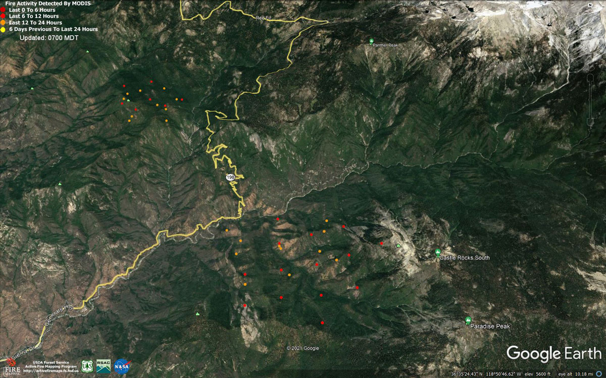
MODIS map of the KNP Complex of Wildfires on Monday morning at 6:00 A.M.
Note: 1,200 Pixels Wide - Note: Older Yellow not shown
MODIS Active Fire Mapping Program Frequently Asked Questions
Note: Click here for Tuesday's Updates on the Sequoia National Park KNP Complex Wildfires
Evening Update: KNP Complex Fire Update for Monday Evening, 1,037 acres with 130 personnel.
Basic Information
| Current as of | 9/13/2021, 4:03:15 PM |
| Incident Type | Wildfire |
| Cause | Lightning |
| Date of Origin | Friday September 10th, 2021 approx. 07:00 AM |
| Location | Sequoia National Park |
| Incident Commander | Leif Mathieson |
| Coordinates | 36.567 latitude, -118.811 longitude |
Current Situation
| Total Personnel | 130 |
| Size | 1,037 Acres |
| Fuels Involved |
Timber, Chaparral |
| Significant Events |
Observed fire activity: Flanking, backing, rolling out, uphill runs |
Outlook
| Planned Actions |
Use aviation resources to moderate fire behavior while available hand crews look for opportunities for direct and indirect line construction. Prevent fire from crossing major drainages. Prepare infrastructure for arrival of fire and provide protection during fire passage. |
| Projected Incident Activity |
12 hours: Colony fire backs off ridgetop. Paradise fire rolls out to north and runs upslope to the south. 24 hours: Colony fire backs off ridgetop, slope reversal results in uphill runs to north and east towards Giant Forest and Lodgepole. Paradise fire rolls out to north and runs upslope to the south, slope reversal results in uphill runs to north and east towards Giant Forest. 48 hours: Colony fire backs off ridgetop in all directions. Paradise fire rolls out to north and slope reversal results in uphill runs to north and east towards Giant Forest while fire runs upslope to ridgetop to the south. 72 hours: Colony fire spreads through Yucca Creek and Marble Fork Kaweah drainages. Paradise fire spreads through the Middle and East Fork Kaweah drainages. Anticipated after 72 hours: Colony fire spreads through Yucca Creek and Marble Fork Kaweah drainages. Paradise fire spreads through the Middle and East Fork Kaweah drainages. |
Current Weather
| Weather Concerns |
A dry onshore flow will maintain dry conditions over the fire through the week. Afternoon highs will remain a few degrees above seasonal average over the fire through the middle of the week. A cooling trend will take place beginning on Thursday and continue through next weekend. Good ventilation will favor fire growth. Westerly afternoon and evening winds of 15 to 25 mph with gusts to 40 mph will continue to surface over the wind prone mountain and desert areas through the middle of this week. |
Update: Fire Activity
The KNP Complex, comprised of the Paradise Fire and the Colony Fire in Sequoia National Park, continued to grow yesterday. The most recent mapping showed the Paradise Fire at 807 acres and the Colony Fire at 230 acres. Extremely smoky conditions under an inversion layer have prevented further mapping thus far today.
The Paradise Fire, burning south of the middle fork of the Kaweah River, has prompted a mandatory evacuation of the Mineral King area, from the Oak Grove Bridge to the end of the road in Mineral King Valley, effective yesterday evening. It has also prompted an evacuation warning for part of the community of Three Rivers. The evacuation warning covers all points on both sides of Highway 198, east of the intersection of Highway 198 and North Fork Drive. The evacuation warning does not include points located on North Fork or South Fork Drive. To view maps that show these evacuation areas, visit https://tularecounty.ca.gov/emergencies.
Those in the mandatory evacuation order area must leave immediately. Those in the evacuation warning area should prepare to leave, should the warning escalate to an order.
These lightning-ignited fires are burning in extremely steep, densely vegetated areas. Ground access is challenging on the Colony Fire and has thus far proved impossible on the Paradise Fire. There are currently 130 people assigned to the KNP Complex, with more resources on the way. A type 2 incident management team from the Northern Rockies Region has been ordered and is expected to transition into place later this week. Source: Sequoia and Kings Canyon National Parks
The evacuation warning covers all points on both sides of Highway 198, east of the intersection of Highway 198 and North Fork Drive. The evacuation warning does not include points located on North Fork or South Fork Drive. Those in the evacuation warning area should prepare to leave, should the warning escalate to an evacuation order.
September 13, 2021 - Sequoia National Park KNP Complex Wildfires Update for Monday Morning, 1,037acres.
Basic Information
| Current as of | 9/13/2021, 11:28:27 AM |
| Incident Type | Wildfire |
| Cause | Lightning |
| Date of Origin | Friday September 10th, 2021 approx. 07:00 AM |
| Location | Sequoia National Park |
| Incident Commander | Leif Mathieson |
| Coordinates | 36.567 latitude, -118.811 longitude |
Current Situation
| Total Personnel | 130 |
| Size | 1,037 Acres |
| Fuels Involved |
Timber, Chaparral |
| Significant Events |
Observed fire activity: Flanking, backing, rolling out, uphill runs |
Outlook
| Planned Actions |
Use aviation resources to moderate fire behavior while available hand crews look for opportunities for direct and indirect line construction. Prevent fire from crossing major drainages. Prepare infrastructure for arrival of fire and provide protection during fire passage. |
| Projected Incident Activity |
12 hours: Colony fire backs off ridgetop. Paradise fire rolls out to north and runs upslope to the south. 24 hours: Colony fire backs off ridgetop, slope reversal results in uphill runs to north and east towards Giant Forest and Lodgepole. Paradise fire rolls out to north and runs upslope to the south, slope reversal results in uphill runs to north and east towards Giant Forest. 48 hours: Colony fire backs off ridgetop in all directions. Paradise fire rolls out to north and slope reversal results in uphill runs to north and east towards Giant Forest while fire runs upslope to ridgetop to the south. 72 hours: Colony fire spreads through Yucca Creek and Marble Fork Kaweah drainages. Paradise fire spreads through the Middle and East Fork Kaweah drainages. Anticipated after 72 hours: Colony fire spreads through Yucca Creek and Marble Fork Kaweah drainages. Paradise fire spreads through the Middle and East Fork Kaweah drainages. |
Current Weather
| Weather Concerns |
A dry onshore flow will maintain dry conditions over the fire through the week. Afternoon highs will remain a few degrees above seasonal average over the fire through the middle of the week. A cooling trend will take place beginning on Thursday and continue through next weekend. Good ventilation will favor fire growth. Westerly afternoon and evening winds of 15 to 25 mph with gusts to 40 mph will continue to surface over the wind prone mountain and desert areas through the middle of this week. |
Click here for: Sunday information on the fires
