


California and National Drought Summary for September 14, 2021
Summary
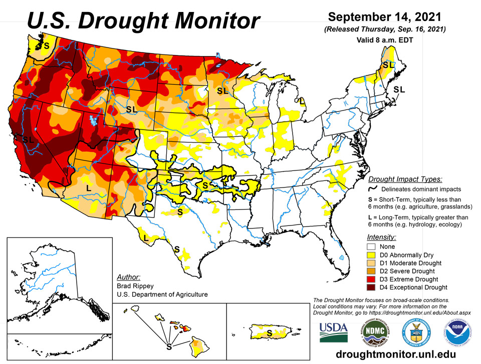
September 16, 2021 - Open weather across much of the country favored summer crop maturation and fieldwork, including harvest efforts and winter wheat planting. By September 12, more than one-third (37 percent) of the U.S. corn was fully mature, while 38 percent of the soybeans were dropping leaves, versus respective 5-year averages of 31 and 29 percent. Meanwhile, among the 13 major production states that have planted some winter wheat, all except Oregon were at or ahead of the 5-year average pace. Oregon’s delay—4 percent planted, versus 7 percent on average—can be attributed to producers’ hesitancy to sow winter wheat due to drought. Rain was observed, however, in several regions, including parts of the South and East. Portions of the Gulf Coast region had to contend with Hurricane Nicholas, the eighth Atlantic Basin tropical cyclone to make a U.S. landfall in 2021. Nicholas, briefly a Category 1 hurricane, moved ashore on Texas’ Matagorda Peninsula around 12:30 am CDT on September 14, delivering heavy rain and gusty winds to the middle and upper Texas coast. Aside from the western Gulf Coast region, some of the heaviest rain (locally 4 inches or more) fell in northern New England, chipping away at lingering, long-term drought. Locally heavy showers also dotted the lower Southeast, including Florida’s peninsula. Lower Southeastern rainfall was enhanced by the arrival and passage of minimal Tropical Storm Mindy, which made landfall on St. Vincent Island, Florida, at 8:15 pm CDT on September 8. Mindy’s sustained winds were briefly near 45 mph, followed by weakening the following day as the remnant circulation moved northeastward across northern Florida and southeastern Georgia. Late in the drought-monitoring period, showers and thunderstorms provided some limited drought relief in the upper Great Lakes region. Elsewhere, fleeting showers dampened some of the driest areas of the West, temporarily aiding wildfire containment efforts. However, hot, dry weather soon returned across the West, limiting the overall benefit of the precipitation. In fact, temperatures broadly averaged above normal across the western half of the country.
Northeast
Heavy rain chipped away at remaining moderate to severe drought (D1 to D2) near the Canadian border, while little change was observed across a lingering area of dryness (D0) in the central Appalachians. Some of the heaviest rain fell in Maine, where Bangor measured 3.34 inches on September 9-10. However, an ongoing drought impact in Maine was poor pasture condition (rated 39% very poor to poor on September 12, according to the U.S. Department of Agriculture). Meanwhile, a small area of moderate drought (D1) persisted on Cape Cod, Massachusetts, due to ongoing low groundwater levels.
Southeast
Patches of abnormal dryness (D0) stretched from coastal Georgia to the piedmont of Virginia, with generally minor changes from the previous week. On September 12, the U.S. Department of Agriculture reported that North Carolina led the region with topsoil moisture rated very short to short (47%) and pastures rated very poor to poor (22%).
South
While former Hurricane Nicholas soaked the western Gulf Coast region, many of parts of the South continued to experience short-term drying. As a result, abnormal dryness (D0) broadly expanded across Arkansas, Oklahoma, and Texas, extending into northwestern Mississippi and western Tennessee. Pockets of moderate drought (D1) also developed. By September 12, Arkansas led the region—according to the U.S. Department of Agriculture—with topsoil moisture rated 69% very short to short, followed by Oklahoma (60%) and Texas (59%). At times, heat has been a factor in rapidly worsening conditions. In Texas, Borger posted a high temperature of 106°F on the 10th, edging the monthly record of 105°F originally set on September 5, 1995. Elsewhere in Texas, Del Rio noted highs of 100°F or greater on each of the first 10 days in September.
Midwest
Short-term dryness (D0) has begun to expand across southern and eastern sections of the region, favoring summer crop maturation but reducing topsoil moisture. Meanwhile, long-term drought issues persisted across the upper Midwest, despite some recent rainfall. By September 12, the U.S. Department of Agriculture reported that topsoil moisture was at least one-third very short to short in each Midwestern State except Wisconsin, led by Indiana (47%). During the week ending September 12, very short to short values increased by more than 10 percentage points in Indiana and Ohio. In contrast, locally heavy rain was observed in the Great Lakes region, particularly across portions of Michigan and Wisconsin. Elsewhere, lingering impacts from summer drought left 63% of Minnesota’s pastures in very poor to poor condition on September 12.
High Plains
Short-term dryness and drought has become more apparent in recent weeks across the southern section of the region, including parts of Kansas and Colorado, aggravated by periods of late-summer heat. A monthly record of 89°F was tied on September 10 in Alamosa, Colorado. Alamosa again reached 89°F on September 11, tying the record first set on September 5 and 6, 2020, while Colorado Springs, Colorado, achieved a new September standard (98°F; previously, 97°F on September 6, 2020). Across the High Plains, September 10-11 featured consecutive triple-digit, daily-record highs in communities such as McCook, Nebraska (102 and 104°F); Goodland, Kansas (103 and 102°F); and Burlington, Colorado (101 and 100°F). Dodge City, Kansas (105°F on the 11th), achieved a 105-degree reading in September for only the third time on record, following 106°F on September 3, 1947, and 107°F on September 1, 2011. Farther north, there were some adjustments (mostly improvements) to the drought depiction, primarily in the Dakotas, based on favorable impacts from recent rain events. For example, improvements in topsoil moisture have led to some greening of drought-affected pastures and have encouraged winter wheat producers to begin planting. Still, the U.S. Department of Agriculture reported on September 12 that topsoil moisture was 64 to 71% very short to short in the Dakotas, while rangeland and pastures were rated 77 to 80% very poor to poor, reflecting the long road ahead regarding drought recovery. On the same date, statewide topsoil moisture on the High Plains ranged from 39% very short to short in Nebraska to 79% in Wyoming.
West
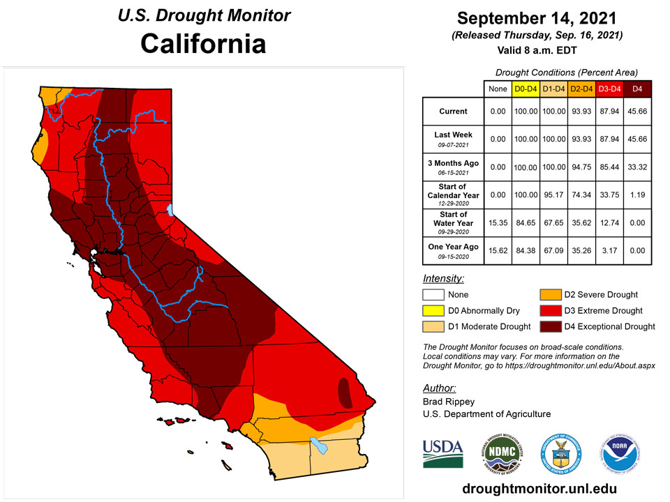
Any benefit from patchy rainfall across northern California and the interior Northwest was largely offset by above-normal temperatures. Still, with rainfall totaling 0.37 inch on September 10, Redding, California, experienced its wettest day since April 25, when 0.39 inch fell. Record-setting rainfall totals for September 10 included 0.63 inch in Ephrata, Washington; 0.61 inch in Redmond, Oregon; and 0.26 inch in Red Bluff, California. Most areas of the West had no change in the drought depiction; however, changes in the Northwest were a mix of slight improvement and minor degradation, mostly due to assessment of earlier precipitation events, water-supply reports, and vegetation health. According to the U.S. Department of Agriculture, topsoil moisture was rated 100% very short to short on September 12 in Washington, followed by 96% in Montana, 85% in California, 83% in Oregon, 79% in Wyoming, and 73% in Idaho. Meanwhile, USDA reported that at least one-half of the acreage devoted to rangeland and pastures was rated in very poor to poor condition is eight of the eleven Western States, led by Washington (96%), Montana (88%), and Oregon (87%). At the end of August, California’s 154 intrastate reservoirs contained 13.8 million acre-feet of water, just 60% of average for the date. Preliminary reports indicated that statewide reservoir holdings were less than one-half of the end-of-August average in Nevada, New Mexico, and Oregon. Meanwhile, several dangerous wildfires remained active across northern California and the Northwest. Nationally, year-to-date wildfires through mid-September had charred more than 5.6 million acres of vegetation. Even as Western wildfire activity has slightly waned in recent days, broad reductions in air quality have continued in parts of the region. Four of California’s active wildfires—the Dixie (more than 960,000 acres), Caldor (219,000 acres), Monument Fires (215,000 acres), along with the River Complex (187,000 acres)—were among the twenty largest blazes in state history. The Dixie Fire, initially sparked on July 13, has burned a vast area near Lake Almanor and has made several impressive runs while threatening to become the largest wildfire in California history. That blaze has also destroyed more than 1,300 structures. The Caldor Fire, which was ignited on August 14 just south of Grizzly Flats, California, has destroyed more than 1,000 structures—only the seventeenth wildfire in state history to do so.
Caribbean
In Puerto Rico, there was no change in the depiction, which includes widespread abnormal dryness (D0) and moderate drought (D1) across southern sections and a patch of D0 and D1 along the northwest coast.
The Virgin Islands saw an increase in rainfall last week as mid-September approached, putting the brakes on what had been rapidly-increasing deficits. Some locations benefitted more than others; Windswept Beach, Rohlsen Airport, and King Airport each received 0.5 to 1.5 inches or fain during the last 4 weeks, with September totals only 10 to 25 percent of normal Rohlsen Airport and Windswept Beach. Other locations, however, other spots recorded 1 to 3 inches of rain just last week as a tropical wave moved through, abetting significantly more relief. But despite the increased rainfall, long-term deficits remain entrenched, and even short-term totals are near to below normal where rainfall was more generous. As a result, no changes were made, and D1 was kept intact on St. Croix and St. John. Relief may be indicated soon, however, if the trend of increasing rainfall continues.
Pacific
For the third consecutive week, Alaska reported neither dryness nor drought, as the transition from summer to autumn has been accompanied by widespread precipitation.
In Hawaii, there was little overall change in the depiction, with more than one-third of the island chain experiencing drought for the twelfth consecutive week. However, some of Hawaii’s hardest-hit drought areas—mainly in Maui County—are seeing signs of worsening conditions, including declining vegetation health. Extreme drought (D3) was introduced across the southern part of Molokai, while Lanai noted widespread worsening from moderate to severe drought (D1 to D2) and from severe to extreme drought (D2 to D3).
No abnormal dryness or drought is affecting Palau. Koror reported 13.36 inches of rain for the month of August 2021. This was the third consecutive month of subnormal rainfall, though August was jbarely shy of normal. Last week, Koror recorded almost 5 inches of rain, bringing their mid-September total to 6.35 inches, which is somewhat above normal. Palau Airport – after a dry start to the month – recorded 7.65 inches of rain last week. As this is a relatively wet time or year, even somewhat below-normal rainfall is sufficient to keep drought impacts at bay.
The Mariana Islands also remain free of notable dryness despite generally subnormal rainfall the last 2 to 4 months. The first half of September brought only 2.5 to 3.0 inches of rain to Guam and Saipan, which is about half of normal. This trend only dates back about 6 weeks at Saipan, where surplus rain fell for several months before the drier spell. Guam has observed less abundant rain relative to normal, but throughout the Islands, this is a wet time of year, and even a few months of subnormal rain is sufficient to squelch any impactful dryness.
Dry conditions have intensified at Kapingamarangi in the Federated States of Micronesia, and moderate drought (D1) has been introduced there. Last week, 1.65 inches of rain fell – only slightly below normal – but it brought amounts since the beginning of August to just over 6 inches, whereas normal is over 15 inches. Private water tanks on Kapingamarangi have dropped to 10 percent of capacity, giving them a cushion of only a couple of months beyond typical demand. Should acute dryness continue, water supplies will dwindle further, potentially bringing about serious deficiencies. Fortunately, the rest of the Federated States of Micronesia are free from any impactful dryness. August was drier than normal across most islands, and subnormal rains date back to early summer in a few spots, but this being the wetter time of year, sufficient rain has fallen to preclude any concerns. In addition, following 1 to 3 months being drier than normal, September has doused Yap, Chuuk, and Woleai with 8 to 15 inches of rain, which is approximately 2 to 3 times normal at the latter 2 locations. Dry conditions have intensified at Kapingamarangi in the Federated States of Micronesia, and moderate drought (D1) has been introduced there. Last week, 1.65 inches of rain fell – only slightly below normal – but it brought amounts since the beginning of August to just over 6 inches, whereas normal is over 15 inches. Private water tanks on Kapingamarangi have dropped to 10 percent of capacity, giving them a cushion of only a couple of months beyond typical demand. Should acute dryness continue, water supplies will dwindle further, potentially bringing about serious deficiencies. Fortunately, the rest of the Federated States of Micronesia are free from any impactful dryness. August was drier than normal across most islands, and subnormal rains date back to early summer in a few spots, but this being the wetter time of year, sufficient rain has fallen to preclude any concerns. In addition, following 1 to 3 months being drier than normal, September has doused Yap, Chuuk, and Woleai with 8 to 15 inches of rain, which is approximately 2 to 3 times normal at the latter 2 locations.
Some degree of abnormal dryness has persisted in western parts of the Marshall Islands for several months. Kwajalein was substantially drier than normal during June – August, leading to abnormal dryness (D0) there, while at Ailinglapalap, severely deficient rainfall during May – August (about 15 inches with a normal over 43 inches) led to deepening drought that had reached severe drought (D2) status recently. Fortunately, these areas finally started receiving significant rainfall this month, particularly within the last week. All 3 locations are above normal for September, prompting an improvement to D1 (moderate drought) on Ailinglapalap. Farther south and east, no significant impacts were reported despite a drier than normal July – August. Deficient precipitation was not as deep nor as long-lived as it was farther north and west. Wotje has been particularly dry this month, (0.88 inch which is under one-quarter the normal), but they were the only location reporting surplus rainfall for July – August (over 125 percent of normal), precluding any abnormal dryness (D0+) despite a 2-week lack of substantial rainfall.
Between 0.5 and 1.5 inches fell across American Samoa during the first 2 weeks of September, when normals are closer to 4 inches. But this follows abundant June – August rainfall. Pago Pago reported about 25 inches of rain then, or 7 inches more than normal. As a result, no degree of abnormal dryness (D0+) is appropriate at this time.
Looking Ahead
The remnants of Nicholas will meander over the central Gulf Coast region during the next couple of days, delivering additional rainfall totaling 3 to 6 inches or more from southeastern Louisiana into western Florida. Farther east, a low-pressure system north of the Bahamas will approach the middle Atlantic Coast and may soon become a tropical cyclone. Regardless of development, most of the significant tropical impacts should remain offshore. Elsewhere, a pattern change in the Pacific Northwest will result in cooler weather and widespread showers, starting on Friday. During the weekend, cool, showery weather will spread eastward across the nation’s northern tier—reaching northern sections of the Rockies and High Plains—and southward into northern California. However, generally dry weather will persist from central and southern California to the central and southern High Plains.
The NWS 6- to 10-day outlook for September 21-25 call for the likelihood of below-normal temperatures from the Great Basin to northern sections of the Rockies and High Plains, while warmer-than-normal weather will prevail along and east of a line from southeastern Arizona to Minnesota. Meanwhile, below-normal precipitation across much of the western half of the U.S. should contrast with wetter-than-normal conditions in the Pacific Northwest and from the Mississippi Valley eastward, excluding the northern Atlantic States.
Author(s):
Brad Rippey, U.S. Department of Agriculture
Richard Tinker, NOAA/NWS/NCEP/CPC
Dryness Categories
D0 Abnormally Dry—used for areas showing dryness but not yet in drought, or for areas recovering from drought.
Drought Intensity Categories
D1 Moderate Drought
D2 Severe Drought
D3 Extreme Drought
D4 Exceptional Drought
Drought or Dryness Types
S Short-term, typically less than 6 months (agriculture, grasslands)
L Long-term, typically more than 6 months (hydrology, ecology)
SL Area contains both short- and long-term impacts
Source: National Drought Mitigation Center
