


California Statewide Fire Summary for September 20, 2021
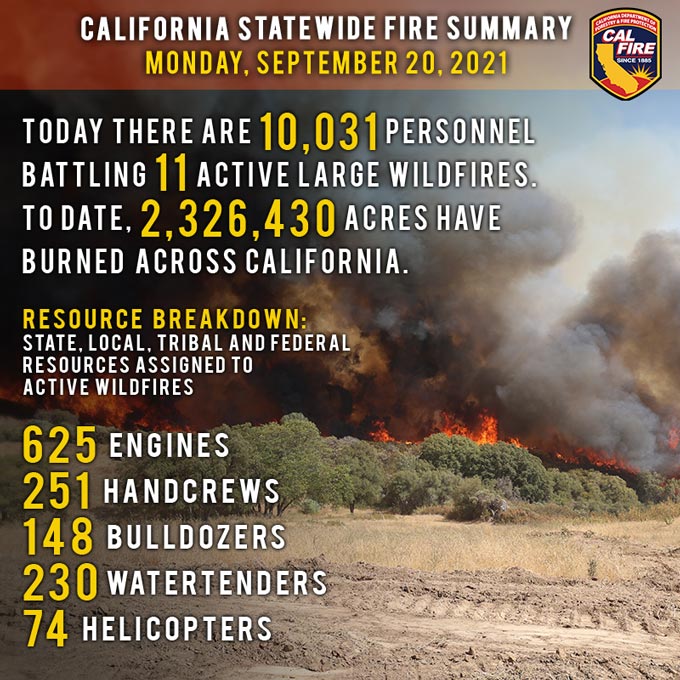
September 20, 2021 - Today, more than 10,000 firefighters continue to work on containing 11 major wildfires and two extended attack wildfires in California. Yesterday, firefighters also responded to and quickly contained 14 new initial attack wildfires. Since the beginning of the year, there have been 7,566 wildfires, burning more than 2.3 million acres in California. In comparison to this same time last year, there were 8,278 wildfires, which burned more than 3.6 million acres.
A Red Flag Warning is in effect into Tuesday morning due to gusty winds and low humidity for portions of the Sacramento Valley and surrounding foothill and mountain terrain, as well as the north bay mountains and east bay hills.
Upper level ridging along the coast will shift inland today and tomorrow returning warm and dry weather to Northern California. North-northwest winds favoring western portions of the Sacramento Valley and northeast winds along the coastal range and bay area ridges as well as along the Western Cascade/Sierra slopes, with gusts of 25 – 40 mph, to develop early this morning and continue into this afternoon. In Southern California, a strong high pressure will build from the Pacific Ocean today and then set up over the desert southwest Tuesday and Wednesday. Temperatures will warm to near normal today and then 5 – 15 degrees above normal Tuesday and Wednesday. Local north to east winds of 10 – 20 mph with gusts to 35 mph will surface across the mountains and below the canyons and passes of Southern California this morning through Tuesday morning.
Do you know what a Fire Weather Watch means in the forecast? Or a Red Flag Warning? A Fire Weather Watch most often precipitates a Red Flag Warning and tells you that critical fire weather is on the way. Gusty winds and low humidity are the most common reason for issuing the watches and warnings. Click here to learn more about this and what CAL FIRE does to prepare.
Fires of Interest:
**Unified Command Fires**
Dixie Fire, Butte, Plumas, Lassen, Tehama & Shasta Counties (more info…)
Feather River Canyon
*963,195 acres, 90% contained
*More than 1,600 structures threatened, 1,329 destroyed
*2nd Largest and 14th Most Destructive Wildfire in California history
*Evacuation orders and warnings in place for multiple communities
*Repopulation ongoing where safe to do so
*Damage assessment is ongoing
Evacuation orders and warnings in place for multiple communities
*Unified Command CAL FIRE, USFS, BLM, and National Park Service
*CA IMT Team 14, CA IMT Team 1, and NIMO Team 1 in command
French Fire, Kern County (more info…)
West of Lake Isabella – Sequoia National Forest
*26,535 acres, 98% contained
*Unified Command USFS and BLM
Windy Fire, Tulare County
*23,801 acres, 4% contained.
*Unified Command USFS, TIA and TCFD
**CA IMT 2, Team 11 in command
**Federal Incidents**
Antelope Fire, Siskiyou County (more info…)
South of Tennant – Klamath National Forest
*145,632 acres, 88% contained
*CA IMT 2, Team 10 (Petterson) in command
Beckwourth Complex, Lassen/Plumas Counties (more info…)
Northeast of Beckwourth – Plumas National Forest
*105,670 acres, 98% contained
Caldor Fire, El Dorado County (more info…)
South of Grizzly Flats – El Dorado National Forest
*219,060 acres, 72% contained
*15th largest and 16th Most Destructive Wildfire in California history
*Evacuation orders and warnings remain in place
*Damage inspection is ongoing
*Repopulation ongoing where safe to do so
*Unified Command CAL FIRE and USFS
*CA IMT 2, Team 12 (Nobles) in command
KNP Complex, Tulare County (more info...)
Milk Ranch Peak – Sequoia National Park
*23,743 acres, 0% contained
*Southern Area IMT Blue Team in command
*Includes the Paradise Fire and Colony Fire
McCash Fire, Siskiyou County (more info…)
Ten Bear Mtn McCash Creek - Six Rivers National Forest
*84,471acres, 22% contained
*Great Basin IMT Team 7 is in command
Monument Fire, Trinity County (more info…)
West of Big Bar – Shasta-Trinity National Forest
*218,457 acres, 53% contained
*16th largest fire in California history
*Northern Rockies IMT 1, Team 2 (Turman) in command
River Complex, Siskiyou & Trinity Counties (more info…)
West of Callahan – Klamath National Forest
*195,779 acres, 50% contained
*19th largest wildfire in California history
*Complex is comprised of 23 fires; 16 fires contained
*CA IMT Team 2 in command
Tamarack Fire, Alpine County (more info…)
South of Gardnerville – Humboldt-Toiyabe National Forest
*68,637 acres, 84% contained
**Extended Attack Incidents**
Emigrant Fire, Los Angeles County (more info...)
Near Pyramid Lake
*255 acres, 61% contained
Hopkins Fire, Mendocino County (more info…)
Near Capella
*257 acres, 98% contained
Source: CAL FIRE
