


California and National Drought Summary for September 28, 2021
Summary
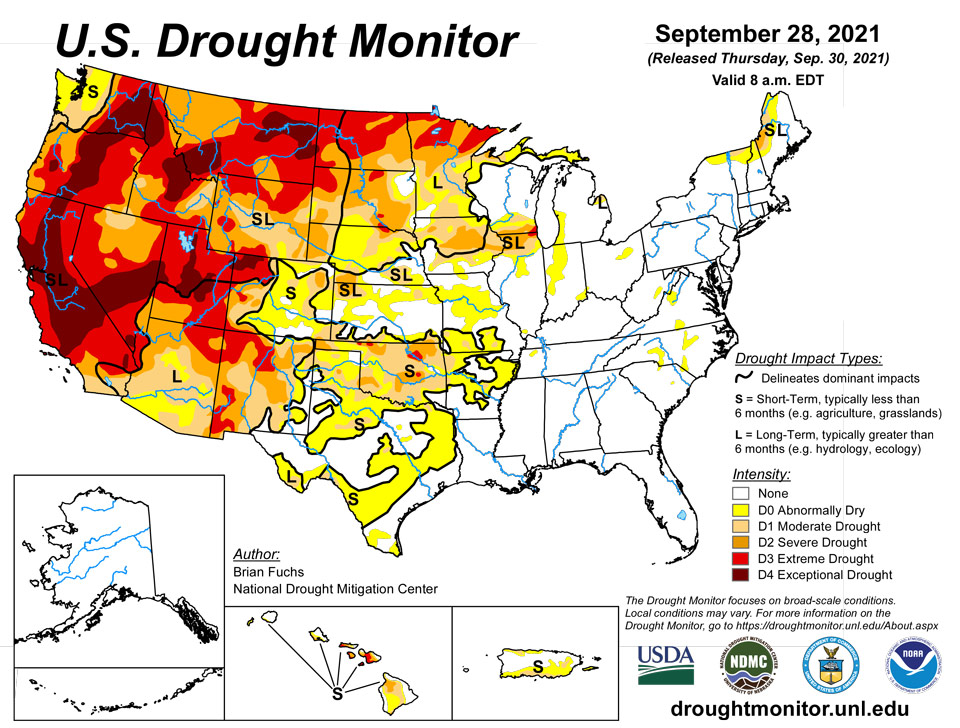
September 30, 2021 - Warm and dry conditions dominated much of the western half of the United States while some needed rain fell on portions of the Midwest, Mid-Atlantic, and into the Northeast. Some late summer precipitation also fell in the deserts of Arizona and New Mexico as well as along the coastal regions of the Pacific Northwest. As the 2021-22 water year came to a close, the West, northern Plains and upper Midwest had the poorest recorded precipitation while portions of the South and Southeast have recorded 110-150 % of normal precipitation during this time. Over the last week, temperatures were well below normal in the South and Southeast with some areas of Alabama and Mississippi at 4-8 degrees below normal. The warmest temperatures were in the northern Rocky Mountains and into New England where readings were 6-8 degrees above normal.
Northeast
Temperatures were above normal in the region with portions of northern Maine recording readings 6-10 degrees above normal. Most areas in the region recorded rain this week with portions of Pennsylvania, New York, and Maine having 200-400% of normal precipitation for the week. The rains helped to ease the drought conditions in northern and western Maine where improvements to both moderate drought and abnormally dry conditions were made. Moderate drought was also removed from Cape Cod this week with some lingering groundwater issues remaining. Abnormally dry conditions were also improved in portions of West Virginia and northern Virginia in response to the wet week in the region.
Southeast
Scattered precipitation dominated the region along with cooler than normal temperatures. The greatest precipitation was recorded over central portions of North Carolina and the northeast portions of South Carolina as well as in central Georgia. Temperatures were generally 2-4 degrees below normal for the region while western Alabama and northwest Mississippi were 6-8 degrees below normal. With not much dryness or drought in the region, the only changes made on the map this week were improvements to abnormally dry conditions in the Carolinas as well as southern Virginia.
Midwest
Temperatures were variable in the region with the northern areas 1-2 degrees above normal while the southern regions were 3-4 degrees below normal. The area from central Illinois into Indiana, Ohio, and southern Michigan recorded the most rain this week with portions of northern Indiana recording over 500% of normal. Abnormally dry conditions were improved over northwest Ohio, northeast Indiana, southern Michigan and portions of southern Wisconsin due to the most recent rains. Where it continued to be dry, drought not only intensified but expanded in portions of Iowa, northern Illinois, southern Wisconsin and southern Missouri. Extreme drought has expanded in the Chicagoland area where this year is looking to be one of the driest on record. Severe drought expanded over much of central Iowa and into northern Illinois and southern Wisconsin and a few small areas of moderate drought were added in southern Missouri.
High Plains
Almost the entire region was dry this week with only light precipitation recorded in portions of the region. Most all of the region was at or above normal for temperatures this week with the warmest readings in the Dakotas where temperatures were 6-8 degrees above normal. The dry weather coupled with the warm temperatures accelerated grain dry down and maturity, kickstarting harvest in the area. It also allowed for drought to both expand and intensify. Portions of northwest North Dakota had extreme drought conditions return. Moderate and severe drought were expanded over portions of eastern Colorado, northern and southern Kansas, western and central Nebraska, southwest South Dakota and southeast Wyoming. Severe and extreme drought were also expanded over north central Wyoming. The warm and dry conditions, especially in September, have been the catalyst for degradation over the region that has remained dry.
South
Temperatures for the week were cooler than normal over most of the region with departures of 2-4 degrees below normal quite common. Portions of west Texas and the panhandles of both Oklahoma and Texas were at to slightly above normal for weekly temperatures. Only a few areas of Arkansas had much measurable precipitation this week, with dryness dominating the region. Winter wheat being planted into dry soils as well as deteriorating grazing lands have many producers concerned. Almost all of Oklahoma had drought conditions worsen this week with degradation being shown on moderate and severe drought conditions as well as abnormally dry regions expanding. These changes bled into northern and central Texas where large areas of abnormally dry conditions were introduced based upon mainly the last 60 to 90 days.
West
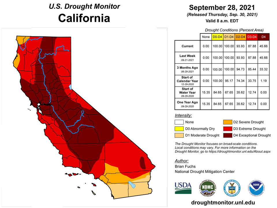
Coastal areas from northern California to Washington as well as Arizona and western New Mexico did record some decent precipitation. For the water year ending at the end of September, the 2021-22 period will go down as one of the driest in portions of California and Nevada, where many areas are at 50% or less of their normal values for the time period. Temperatures this last week were near to slightly above normal, with most places 1-2 degrees above normal for the week. Portions of central and southern Arizona continued to record much-needed rains and areas of moderate drought were improved there this week, with the “L” designation being the prominent impacts in most of southern Arizona where long-term hydrological issues remain. Some exceptional drought was removed in northeast Nevada and into western Utah while exceptional drought was expanded over western Montana. Moderate drought was intensified to severe drought in the northwest portion of Montana while some exceptional drought was improved over northeast Montana.
Pacific
Trade winds over the last week brought with them rainfall over the east-facing windward slopes of the islands. On Kauai, where dryness has continued in the southern portion of the island, severe drought was introduced this week as well as a new pocket of abnormally dry conditions in the northeast. No other changes were made in Hawaii this week.
No changes for Alaska this week.
Palau had a very wet week (September 22-28) with a weekly rainfall total at the airport of 4.53 inches and the month-to-date was 19.33 inches. Drought is not a concern across Palau at this time.
The Marianas also had a wet week, with rainfall totals above 5 inches. This was mainly due to Tropical Storm Mindulle. Guam had the most rain, receiving over 7 inches. The month-to-date rainfall for the three locations were over 7 inches. Drought free conditions persisted across the Marianas this week.
Across the Federated States of Micronesia, Pohnpei and Kosrae had the most rain with rainfall totals above 2 inches, resulting in another week of drought free conditions. Yap, Chuuk, Nukuoro, Pingelap, Ulithi, and Woleai had over 1 inch of rain. All of these locations continued to be drought free since their month-to-date rainfall totals were above the threshold of 8 inches to meet most water needs. Kapingamarangi and Lukunor had the least rain at 0.66 inch and 0.69 inch, respectively. Even though this was a dry week for Lukunor, it continued to be drought free since the previous weeks have been wet and its month-to-date rainfall total was over 8 inches. Kapingamarangi's month-to-date was below 4 inches. Short- and long-term moderate drought persisted across Kapingamarangi this week.
Most of the Marshall Islands had a wet week, with rainfall totals surpassing the threshold of 2 inches to meet most water needs. Jaluit, Mili, Majuro, and Wotje continued to be drought free. Kwajalein had 2.90 inches of rain this week, resulting in a month-to-date rainfall total of 9.59 inches. Since the weekly (2 inches) and monthly (8 inches) rainfall total thresholds were surpassed to meet most water needs, a 1-category drought improvement to drought free conditions were made to Kwajalein. Ailinglaplap had the least rain at 1.48 inches. However, its month-to-date rainfall total was over 10 inches. Since the last few months rainfall totals were less than 3 inches, its drought classification was left as short-term moderate drought for this week.
Across American Samoa, rainfall varied across the locations. Pago Pago had 0.79 inch of rain this week, while Siufaga Ridge and Toa Ridge had only 0.15 inch and 0.19 inch of rain, respectively. Month-to-date rainfall totals were less than 3 inches at Pago Pago and Toa Ridge, while Siufaga Ridge had over 4 inches of rain. For this week, drought free conditions persisted across American Samoa.
Caribbean
In Puerto Rico, abnormally dry conditions were added over Vieques and expanded over the eastern portions of the island. Some improvements were made to abnormally dry and moderate drought conditions over the interior of the island in response to the substantial rains during the last week.
Rainfall varied across the USVI. The Cyril E. King Airport, St. Thomas, had only 0.28 inch of rain this week, resulting in a month-to-date of 3.46 inches, which is 63.5% of normal. Year-to-date rainfall at the airport was 84.5% of normal. SPI values at the 1, 3, 6, 9, and 12-months were indicative of drought free conditions. CoCoRaHS stations across the St. Thomas ranged between 0.01 to 0.51 inch of rain for the week and over 3 inches for the month. Although this was a dry week for St. Thomas, drought free conditions persisted.
The Windswept Beach and Cruz Bay 1.6 E CoCoRaHS stations in St. John had 0.08 inch and 0.56 inch of rain, respectively. Both locations had over 4 inches of rain for the month. The year-to-date rainfall total for Windswept Beach was 78.8% of normal. SPI values at the 1, 3, and 6 months were indicative of drought free conditions, while the 9 and 12 months were indicative of abnormally dry conditions. For this reason, long-term abnormally dry conditions persisted across St. John.
In St. Croix, the Henry Rohlsen airport had only 0.79 inch of rain, resulting in a month-to-date rainfall total that was 33.6% of normal and a year-to-date of 64.3% of normal. SPI values at all monthly periods were indicative of severe to exceptional drought. Meanwhile, the CoCoRaHS stations across St. Croix had 0.71 to 2.50 inches of rain for the week and the month-to-date totals were close to 2 inches at the Christiansted 4.1 ESE and close to or over 4 inches at Christiansted 1.8 ESE and Christiansted 1.6 E. For this week, short- and long-term drought continued for St. Croix.
Looking Ahead
Over the next 5-7 days, it is anticipated that the best chances of precipitation will be over the southern Rocky Mountains, Plains, South and into the Midwest and Northeast. The greatest amounts are anticipated over Texas, where up to 4 inches of rain could occur. Temperatures are anticipated to be warmest over the West, northern Plains and Midwest with departures of 9-12 degrees above normal during the period. Cooler than normal temperatures are anticipated over the Four Corners region with departures of up to 3 degrees below normal.
The 6-10 day outlooks show the high probability of above-normal temperatures over the northern Plains and into the northern Rocky Mountains. Near-normal temperatures are expected over portions of the southern Plains and South while there are higher probabilities of below-normal temperatures along the coastal regions of the Pacific Northwest. Precipitation probabilities are greatest over the West and eastern portions of the country while the upper Midwest and Plains have the greatest chances of below-normal precipitation.
Author(s):
Brian Fuchs, National Drought Mitigation Center
Ahira Sanchez-Lugo, NOAA/NCEI
Dryness Categories
D0 Abnormally Dry—used for areas showing dryness but not yet in drought, or for areas recovering from drought.
Drought Intensity Categories
D1 Moderate Drought
D2 Severe Drought
D3 Extreme Drought
D4 Exceptional Drought
Drought or Dryness Types
S Short-term, typically less than 6 months (agriculture, grasslands)
L Long-term, typically more than 6 months (hydrology, ecology)
SL Area contains both short- and long-term impacts
Source: National Drought Mitigation Center
