


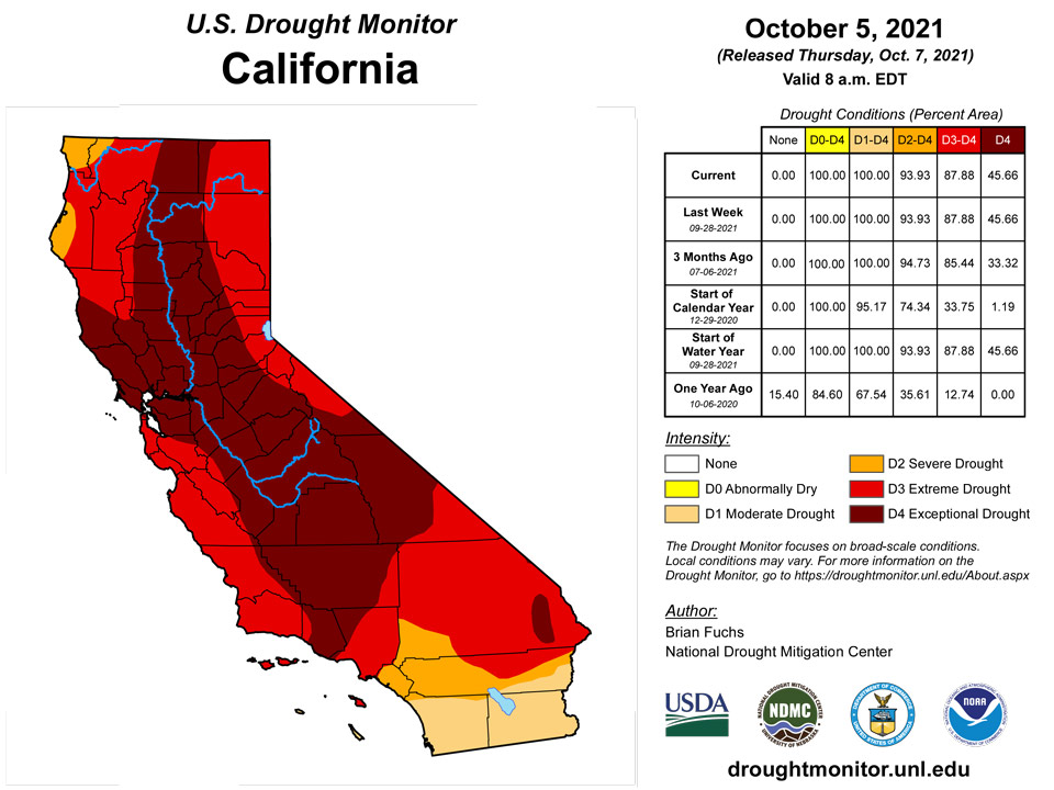
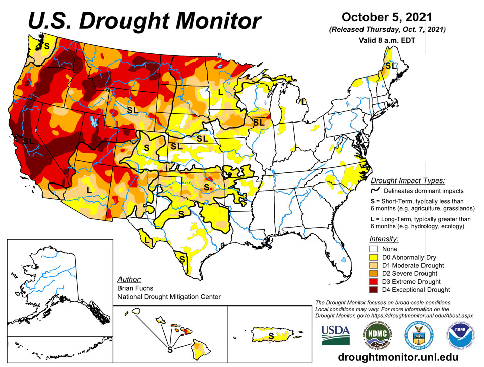
California and National Drought Summary for October 5, 2021
Summary
October 7, 2021 - Several storm systems impacted various regions of the country this week as the transition to autumn continues. Temperatures through the Midwest and northern Plains remained unseasonal with departures of 9-12 degrees above normal. As cooler air came into the West, temperatures were 3-6 degrees below normal in the region and into the Southwest. The Pacific Northwest had several rain events that brought needed moisture into the region. Areas of eastern Arizona, New Mexico and Colorado also had above-normal precipitation for the week. A slow-moving cold front brought with it a line of showers from the Dakotas into Texas. This slow-moving rain maker brought relief to many dry areas of the Plains. Dry conditions dominated the northern Rocky Mountains as well as the coastal regions of the East from the Mid-Atlantic into Florida.
Northeast
The region was mostly dry this week with only a few areas of above-normal precipitation that included northern areas of New York and Vermont, central New York into southern New England, and areas of central Pennsylvania. Most of the region was normal to slightly below normal for temperatures with departures of up to 2 degrees below normal in portions of New England. Portions of northern New York and Vermont had some improvements to abnormally dry and moderate drought conditions, and farther to the west, areas of northern New York had some abnormally dry areas expand. Abnormally dry conditions were eliminated from Cape Code in Massachusetts as recent precipitation eased dryness and impacts.
Southeast
Temperatures were warmer than normal throughout the region with only southern Florida being cooler than normal. Departure from normal temperatures were generally 2-4 degrees above normal and 1-2 degrees below normal in southern Florida. Dry conditions dominated the region with only areas of Alabama and western Georgia having above-normal rains. A large expansion of abnormally dry conditions was introduced in the eastern sections of North Carolina with smaller areas in South Carolina and southeast Virginia. The last 60-90 days have brought with them dry conditions that are starting to impact the region.
Midwest
Temperatures were warm in the region with almost the entire area above normal for the week. Most areas were 4-8 degrees above normal, but portions of northern Minnesota, eastern Iowa and northern Illinois were 12-16 degrees above normal. Precipitation was scattered, but those areas that did receive it saw amounts up to 400% of normal for the week. It remained dry over eastern Iowa, southeast Minnesota, and central Ohio as well as northwest Missouri. Abnormally dry conditions were improved over portions of central and southern Missouri and western Indiana. Widespread improvements were made over much of Minnesota, but even with the recent wetter pattern, lake levels across the state remain low. Abnormally dry conditions were expanded over northern Wisconsin into the Upper Peninsula of Michigan. Abnormally dry conditions were also expanded over northern Missouri and into southern Iowa while moderate and severe drought conditions were expanded over portions of Iowa and northern Illinois.
High Plains
Significant rains fell over portions of western and central Kansas, central and northeast Nebraska and into central South Dakota as well as southeast North Dakota. Temperatures were warm over almost the entire region with departures of 9-12 degrees above normal in North Dakota and northern areas of South Dakota, and generally 3-6 degrees above normal elsewhere. Those areas that have been in long-term drought will continue to see challenges to pasture and rangeland conditions as well as available forage. Hay stockpiles continue to decline and will be more expensive on the open market compared to past years. Improvements to the drought status were made in areas that received the most rain and the indicators showed improvements. In South Dakota, extreme and severe drought was improved in the south and north areas while moderate drought and abnormally dry conditions were improved in the east. Where it remained dry in the western portions of the state, extreme and severe drought were expanded this week. In Nebraska, the dryness over the Panhandle remained a concern and a new area of extreme drought was introduced this week that went into southeast Wyoming. Areas of improvement were confined to central and southwest Nebraska where moderate drought and abnormally dry conditions were improved in response to the recent rains. Areas of eastern Colorado had moderate drought conditions expand this week while severe drought expanded in far southeast Colorado and into southwest Kansas. Areas of northwest Kansas saw improvements of abnormally dry and moderate drought conditions this week.
South
Temperatures across the region were generally warmer than normal with departures of 4-6 degrees above normal common. In contrast to last week, much of the region did see some beneficial rains that put the brakes on the recent dryness. Some areas did miss out, with the Oklahoma and Texas panhandles, east and west Texas and western Arkansas being the driest. Much of the abnormally dry areas introduced last week in Texas were improved this week with even some areas of moderate drought being removed in the south and central portions of Texas. Eastern Texas had an expansion of abnormally dry and moderate drought conditions, and in the Oklahoma panhandle, severe drought was expanded and a new area of extreme drought was introduced that also went into portions of southeast Colorado. Severe drought was expanded slightly in north central Oklahoma where rains missed while other areas of central Oklahoma had improvements to the drought status this week. Most of northern Arkansas had precipitation that helped to improve the abnormally dry conditions, but the spottiness of the rains also means that some areas continue to dry out.
West
As the 2020-21 water year ended, several places set records for driest years ever recorded. In northern California, Redding ended up with 14.24 inches, breaking the previous record low of 19.38 inches in 1990-91 and a normal of 33.52 inches. Red Bluff recorded 9.48 inches compared to the previous record of 10.98 inches in 1975-76 and a normal of 23.12 inches. The Sacramento Executive Airport recorded only 6.61 inches of precipitation for the water year, breaking the record from 1976-77 of 6.62 inches, with normal being 18.14 inches. Rains in the Pacific Northwest and into the Four Corners regions were the only areas with above-normal precipitation for the week. The conditions brought with them cooler than normal temperatures with departures mainly 3-6 degrees below normal, with some even cooler readings in those areas that had the most rain. Warmer than normal conditions dominated the northern Rocky Mountains and into northern Wyoming where temperatures were 3-6 degrees above normal. Some improvements to the extreme drought were made over portions of northwest Colorado into eastern Utah. Extreme drought was also improved over western New Mexico while moderate drought was improved in central New Mexico. Exceptional drought was improved over northeast Washington into northern Idaho while extreme drought was expanded over southern Montana into northern Wyoming with severe and extreme drought expanding over western Montana. Areas of southwest and southern Colorado had moderate and severe drought conditions expand.
Pacific
No changes were made in Alaska this week.
No changes were made in Hawaii this week.
Pago Pago, Siufaga Ridge, and Toa Ridge all received over an inch of rain this week, after Toa Ridge and Pago Pago received less than 4 inches of rain during September. Given the rainfall this week, American Samoa remained free of drought.
The week was mostly wet across the Republic of the Marshall Islands, with most locations receiving near or over 2 inches of rain. The wettest locations were Majuro and Mili, which received at least 6 inches and 7.66 inches of rain, respectively. Heavy rainfall fell on Ailinglaplap this week where moderate short-term drought had been taking place. Rainfall totaling 4.41 inches was enough to replenish water catchment levels, and conditions improved to short-term abnormal dryness. No data was reported for Utirik, so no drought depiction was made there this week.
The Mariana Islands remained free of drought or abnormal dryness this week. Over 2 inches of rain fell at the observing sites on Saipan, while Rota received 1.99 inches of rain. For the second consecutive week, weather on Guam was quite wet, with the last two weeks’ rainfall checking in at 7.39 and 6.45 inches, respectively.
On Yap, 4 inches of rain fell this week, so drought-free conditions continued for another week. The last couple weeks on Ulithi have been drier, but given that over 14 inches of rain fell during September, drought-free conditions continued. As of the time of writing, 0.26 inches of rain had been reported on Woleai, following 1.60 inches last week. However, over 17 inches of rain fell during September, so drought-free conditions continued. No drought depiction was made for Fananu this week, as no data were reported. Chuuk received at least 5.93 inches of rain this week, and drought-free conditions continued. At least 3.20 inches of rain fell on Lukunor this week, so drought-free conditions continued after only 0.69 inches last week. On Nukuoro, at least 5.26 inches of rain fell during the past week, and drought-free conditions continued. On Kapingamarangi, 1.38 inches of rain had been reported this week, continuing a long stretch of weeks that tallied below 2 inches of rain. Short- and long-term moderate drought continued for another week. At least 3.36 inches of rain fell at Pohnpei this week, and drought-free conditions continued. On Pingelap, at least 1.89 inches of rain fell this week. Despite recent drier conditions, September rainfall totaled over 10 inches, so drought-free conditions continued. At least 7.70 inches of rain fell on Kosrae, where drought-free conditions continued.
On Palau, Koror recorded 3.66 inches of rain, while the airport received 5.22 inches of rain. Drought-free conditions continued for another week.
Caribbean
No changes were made in Puerto Rico this week. Some areas of Puerto Rico had good rains, but they seemed to mostly be in areas already improved last week and the conditions did not warrant further improvements at this time.
Rainfall varied from 0.18 inches at Windswept Beach on St. John to 0.31 inches at St. Thomas to 0.67 inches at St. Croix. Groundwater conditions at St. Croix remained mostly unchanged, while short-term precipitation statistics continued to support moderate drought, while long-term precipitation statistics supported moderate drought or worse. Thus, short- and long-term moderate drought continued this week. On St. Thomas, groundwater levels decreased a bit this week; however, precipitation amounts on the short- and long-term do not support abnormal dryness or drought. On St. John, groundwater levels did not substantially change this week, and short-term precipitation amounts do not support drought. However, precipitation amounts on the long-term are abnormally dry, so long-term abnormal dryness continued this week.
Looking Ahead
Over the next 5-7 days, it is anticipated that warmer than normal temperatures will continue to dominate the eastern United States from the Rocky Mountains to the Atlantic coast. Temperatures will be warmest over the Great Lakes region where high temperatures will be 12-15 degrees above normal. The West will have below-normal temperatures with departures of 3-6 degrees below normal throughout the region. The best chances for precipitation will be over the Southeast, with areas of northern Georgia and Alabama and eastern Tennessee projected to record the most rain. The coastal regions of the Pacific Northwest look to stay wet, and wet conditions are anticipated over Nevada, Utah, western Colorado, Wyoming, Idaho and southern Montana. Up to an inch of rain is also anticipated over the northern Plains and Midwest.
The 6-10 day outlooks show the high probability of warmer than normal temperatures over the eastern half of the United States, where the greatest chances of above-normal temperatures are over the Great Lakes region and into the Mid-Atlantic. Above-normal chances of below-normal temperatures are anticipated over the West, with the greatest probabilities over the Great Basin. The best chance of above-normal precipitation is through the Rocky Mountains and Plains states, with the highest probabilities over the northern Plains. The best chances for below-normal precipitation are over the southern deserts of New Mexico, New England, and northern Florida into southern Georgia.
Author(s):
Brian Fuchs, National Drought Mitigation Center
Curtis Riganti, National Drought Mitigation Center
Dryness Categories
D0 Abnormally Dry—used for areas showing dryness but not yet in drought, or for areas recovering from drought.
Drought Intensity Categories
D1 Moderate Drought
D2 Severe Drought
D3 Extreme Drought
D4 Exceptional Drought
Drought or Dryness Types
S Short-term, typically less than 6 months (agriculture, grasslands)
L Long-term, typically more than 6 months (hydrology, ecology)
SL Area contains both short- and long-term impacts
Source: National Drought Mitigation Center
