Click here for Sunday's Updates: KNP Complex Wildfires in Sequoia National Park Sunday, October 10, 2021 Updates
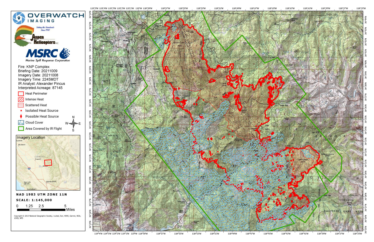
Saturday's Infrared Map
Note: Map is 1,200 pixels wide.
Click here for Sunday's Updates: KNP Complex Wildfires in Sequoia National Park Sunday, October 10, 2021 Updates
Update:
TULARE COUNTY TO DOWNGRADE EVACUATION ORDERS FOR AREAS AFFECTED BY KNP COMPLEX
VISALIA, CA – Effective at 12 p.m. on Saturday, October 9, 2021, county authorities will downgrade the following areas from Evacuation Orders to Evacuation Warnings:
Residences on Hammond, Crest, and Sierra King along Mineral King Road, as well as along Sierra Drive (Highway 198) from Mineral King Road, north to the entrance to Sequoia National Park, (NOT including Sycamore Drive). These areas will include all structures, residential and businesses.
Residences on Sycamore Drive remain under Evacuation Orders at this time. All prior evacuation orders and warnings not addressed here will remain in effect.
Roadblocks will be at the Oak Grove Bridge on Mineral King Road, and on Highway 198 at the entrance to Sequoia National Park.
Effective at 9 a.m. on Saturday, October 9, 2021, residences in Wilsonia will be downgraded to a warning. Residents can only access from the north on Highway 180.
At this time, only residents and business owners are permitted to return. Residents living in these areas may return to their homes after showing proof of residence to law enforcement officers. Proper documentation must include the person’s name and address within the impacted area. Examples include a driver’s license, utility bill or address documentation from the U.S. Post Office for people who use a post office box.
Sequoia and Kings Canyon National Parks will remain closed and only fire personnel are allowed inside the park at this time.
Residents returning to evacuation warning areas should be ready to leave again at a moment’s notice, as the fire is still active in some areas. Conditions may change, which may cause officials to re-issue mandatory evacuation status, if necessary.
Tulare County advises residents returning to communities impacted by wildfires to take caution upon returning to their homes:
• Conduct a thorough inspection of structures, which may have been damaged, to prevent injury;
• Do not consume refrigerated or frozen food stored in appliances that may have lost electricity, and dispose of these items properly;
• Wear personal protective equipment, including long-sleeved shirts and pants, hard hats, safety glasses, leather gloves, and steel toe boots, to reduce risk of injury;
• Be aware of burnt or unstable trees on your route or on your property and hidden hotspots underground which may present hazards;
• Do not enter a confined space (for example, septic tanks, storage tanks, utility vaults, wells) without proper training and equipment;
• Avoid potential electrical hazards such as damaged power lines and electrical equipment that has been exposed to fire heat;
• Be cautious around hazardous and potentially dangerous materials such as propane tanks, gasoline tanks, and chemicals, and seek professional help in assessing or removing any hazardous waste;
• Use proper lifting techniques when removing debris and other items, and seek help from others when moving heavy or bulky items to reduce risk of musculoskeletal injuries;
• Wear personal protective equipment to avoid exposure to smoke and ash, dispose of ash using vacuums equipped with High Efficiency Particulate Air (HEPA) filters;
• During clean up, use a particulate respirator mask, either P95 or P100 (sold at pharmacies), to provide protection from smoke and ash inhalation;
• Avoid burned items that may contain hazardous materials. Avoid ash from decks and fences treated with chromated copper arsenate (a wood preservative) as it may contain lethal amounts of arsenic;
• Do not consume any food, beverages, or medications that have been exposed to burn debris or ash;
• Seek support as needed for emotional stress and mental and physical fatigue resulting from evacuation from and return to your residence;
• Check your homeowner’s insurance policy for information about your home and property coverage; and,
Always be aware of your surroundings and proceed cautiously to avoid hazards when returning to an area affected by wildfire. Seek professional help when assessing potential hazards and seek medical assistance when necessary.
October 9, 2021
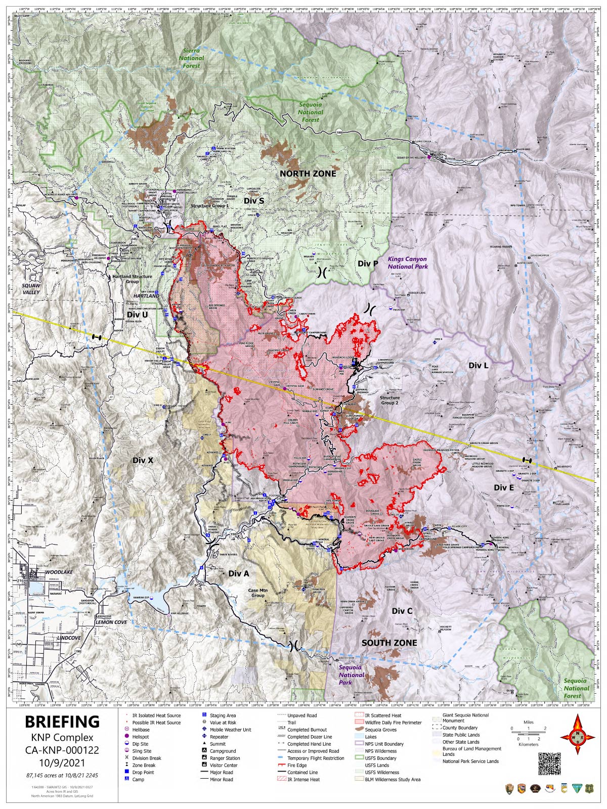
Acres: 87,145 acres
Containment: 20%
Start Date: September 10, 2021
Cause: Lightning
Jurisdiction: Sequoia and Kings Canyon National Parks; Sequoia National Forest
Resources: 1,972 personnel including: 40 crews, 114 engines, 36 water tenders, 21 dozers and 14 helicopters
Announcement: KNP Complex North and South Zone Virtual Community Meeting will be held Sunday October 10, 2021, at 7:00 p.m. The meeting will be live streamed to Sequoia Kings Canyon National Park Facebook Page and Sequoia National Forest Facebook Page. Please email 2021.knp@firenet.gov with questions prior to the meeting.
North Zone: Yesterday, on the north end of the fire, crews worked to mop up hot spots still smoldering after Wednesday night’s burning operation. Firefighters also worked around structures in Wilsonia and nearby sequoia groves. Rain fell on the fire yesterday with some areas receiving up to three-tenths of an inch, significantly decreasing fire behavior. Unfortunately, because of the hazards of rocks and snags falling down slope firefighters were unable to engage directly on the east side along Generals Highway. Humidity will remain high today and the fuels will remain moist. Although the potential for the fire to be spread by rolling materials still exists, the chances of forward progress are minimal.
South Zone: After many weeks of hard work, containment has increased along portions of the western perimeter. Resources previously working in these areas are being strategically placed throughout the South Zone to assist with ongoing suppression efforts. Firefighters are moving back into the fire area after yesterday’s weather limited safe access. Line construction and hose lay is being put in place on the southwest corner to prevent further spread to the west of Mineral King Road. Handline and hose lays on the southeast corner connecting Mineral King Road and the East Fork Kaweah River have been completed. Crews are working to improve lines and mop up any remaining pockets of heat. Preparation and protection tactics are being utilized in Atwell Grove in the event the fire continues to move east. California Incident Management Team 1 has arrived and will assume command of the south zone at 6:00 pm tonight.
Weather: Yesterday’s storms brought a wetting rain over the majority of the fire area. Today will be sunny and dry with light, north-northwesterly winds.
Safety: As we start the weekend, please continue to respect closures and reduce speeds when traveling in and around the fire area.
Evacuations: Evacuation ORDERS and WARNINGS are in place. For the most up-to-date information, visit: https://nifc.maps.arcgis.com/apps/webappviewer/index.html?id=4b2ac27b5c8943ed92c0e77aa94daca0. Learn to prepare for an evacuation by visiting https://www.readyforwildfire.org/.
Closures: Sequoia and Kings Canyon National Parks are closed west of the Pacific Crest Trail and south of the ridgeline which lies north of Ionian Basin. In addition, the BLM Case Mountain Extensive Recreation Management Area and major portions of the Sequoia National Forest are also closed. View closures at https://inciweb.nwcg.gov/incident/closures/7838/
Smoke Impacts: As weather warms up over the next few days, smoke may be visible as fire consumes unburned pockets of vegetation within the fire perimeter. Current air quality updates can be found at https://www.wildlandfiresmoke.net/outlooks/FresnoCA.
Basic Information
| Current as of | 10/9/2021, 9:08:38 AM |
| Incident Type | Wildfire |
| Cause | Lightning |
| Date of Origin | Friday September 10th, 2021 approx. 07:00 AM |
| Location | Sequoia National Park |
| Incident Commander | David Bales |
| Incident Description | Complex |
| Coordinates | 36.567 latitude, -118.811 longitude |
Current Situation
| Total Personnel | 1,972 |
| Size | 87,145 Acres |
| Percent of Perimeter Contained | 20% |
| Fuels Involved |
Timber (Litter and Understory) Chaparral (6 feet) Short Grass (1 foot) |
| Significant Events |
Fire behavior observed: Minimal Creeping Smoldering Narrative: Precipitation limited fire behavior to creeping and smoldering. |
Outlook
| Planned Actions |
NORTH ZONE: Utilize direct tactics with ground resources and heavy equipment. Holding and securing direct line. Structure protection and perimeter control measures will be taken around structures within threatened communities. Continued protection and mitigation measures for all sequoia groves within the fire area. When attributes of fire behavior are favorable to the landscape, allow fire to spread to aid in fuels reduction in around the groves. Potential repopulation within the next 48 hours. SOUTH ZONE: Continue to patrol, monitor and mop up DIV X, A and C. Scout for opportunities to create contingency lines in the Case Mountain area, including prep of infrastructure and mastication in Giant Sequoia Groves. Implement structure and infrastructure protection in the Three Rivers area, coordinate and communicate with Cal Fire on operations that take place in Silver City and Mineral King. Coordinate with READS to implement protection measures in the Atwell Grove, East Fork Grove, Case Mountain Grove as priorities a re delivered to Operations. |
| Projected Incident Activity |
12 hours: Rain will moderate fire behavior. Low fire behavior is expected. 24 hours: Yesterdays rain has moistened the fuels, keeping fire behavior low. 48 hours: Fuels begin to dry, which will result in creeping and smoldering fire behavior. 72 hours: The drying process continues. Decreased fire behavior can be expected with lower humidity and sunlight. Anticipated after 72hours: Moderate fire behavior can be expected. |
Current Weather
| Weather Concerns |
Weather disturbance moved through the fire area bringing widespread wetting rain and much cooler temperatures. Cold conditions tonight with freezing temperatures at higher elevations. Drier weather returns on Saturday and Sunday as weak high pressure builds over the region. Temperatures will trend upward both Saturday and Sunday with relative humidity trending lower. |
Lookout Towers on the KNP Complex:
The Milk Ranch area burned in the early days of the KNP Complex. As fire activity in that area has substantially cooled, on October 2, crews were able to access it to perform a preliminary assessment of the damage. While the radio repeater equipment was destroyed by the fire, the steel structure and the lookout room appear to be still structurally sound. A more thorough assessment will be completed when conditions in that area have stabilized further.
Buck Rock Fire lookout is being prepped with structure protection wrap around the wooden components in anticipation that the area could see fire. The area where Buck Rock is located has a lot of rocky terrain with sparse fuels, which should be helpful in slowing fire spread into those areas, especially with cooler and wetter weather predicted in the coming days. However, there is a great deal of prep work occurring in that area of Sequoia National Forest right now, as the fire has been very active west of there. Crews are working to hold fire some distance west of Buck Rock (close to the NPS boundary, west of the Generals Highway).
Park Ridge Fire lookout is very close to the northwest edge of the fire. In fact, handlines from the planned, but not yet executed, Park Ridge Prescribed Burn are being used as primary holding features in the fire suppression efforts in that area, right by the lookout. While this does mean that fire is burning very near the lookout, it also means that firefighters are literally on the ground protecting that structure at close range, which has often not been possible for safety reasons elsewhere on this fire.
October 9, 2021 - KNP Complex Fire in Sequoia National Park updates for Saturday: 87,145 Acres with 20% Containment.
Overnight Infrared Flight Notes: Interpreted Size: 87,145 Interpreted Acres - Growth since last flight: About 1,193 Acres
Growth acreage calculated using 85,952ac figure from 20211007 1914PDT update as the starting acreage.
-Cloud/smoke obscuring imagery NW Perimeter IVO NF-14S75 and Old Sawmill Rd.
-Cloud/smoke obscuring imagery SE Corner in direction of Silver City / Cabin Cove.
-Cloud/smoke obscuring imagery for much of the SSW border and southern interior.
Acreage is almost certainly underreported as I did not capture areas that were obstructed by clouds/smoke, but most likely were burned or burning at expanded points along the perimeter. Isolated and scattered heat may be underreported as well. Only positively identified heat locations were recorded on the map.
Click here for: KNP Complex Wildfires in Sequoia National Park Friday, October 8, 2021 Updates
Saturday's Briefing Map
Briefing Map Shows Divisions, Uncontrolled Fire Edge, Completed Dozer Lines.
Note: Map is 1,200 pixels wide.