


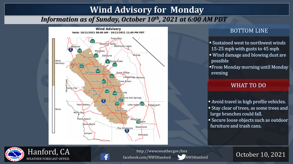
October 10, 2021 - The National Weather Service Hanford Office reports a strong low pressure system will bring windy conditions to much of Central California beginning Monday morning.
Northwest winds of 15 to 25 mph with gusts to 45 mph are likely.
Motorists should take caution, as strong crosswinds are possible.
Gusty winds will continue through Monday evening.
Wind Advisory
URGENT - WEATHER MESSAGE
National Weather Service Hanford CA
531 AM PDT Sun Oct 10 2021

West Side Mountains north of 198-Los Banos - Dos Palos-Merced -
Madera - Mendota-Planada - Le Grand - Snelling-Coalinga - Avenal-
West Side of Fresno and Kings Counties-Caruthers - San Joaquin -
Selma-Fresno-Clovis-West Side Mountains South of 198-
Buttonwillow - Lost Hills - I5-Delano-Wasco-Shafter-Hanford -
Corcoran - Lemoore-Visalia - Porterville - Reedley-Buena Vista-
Bakersfield-Southeast San Joaquin Valley-
South End San Joaquin Valley-Tehachapi-
Frazier Mountain Communities-
Including the cities of San Luis Reservoir, Los Banos, Merced,
Madera, Atwater, Planada, Lake Mcclure, Le Grand, Avenal,
Coalinga, Lemoore Station, Five Points, Kettleman City, Selma,
Sanger, Parlier, Kingsburg, Kerman, Fresno, Blackwells Corner,
McKittrick, Lost Hills, Buttonwillow, Delano, Wasco, Alpaugh,
Shafter, Hanford, Lemoore, Corcoran, Goshen, Visalia, Tulare,
Porterville, Taft, Bakersfield, Richgrove, Lamont, Arvin,
Tehachapi, and Frazier Park
531 AM PDT Sun Oct 10 2021

...WIND ADVISORY IN EFFECT FROM 8 AM TO 11 PM PDT MONDAY...

* WHAT...Northwest winds 15 to 25 mph with gusts up to 45 mph
  expected.

* WHERE...Portions of Central California including the West Side
  Hills and San Joaquin Valley.

* WHEN...From 8 AM to 11 PM PDT Monday.

* IMPACTS...Gusty winds could blow around unsecured objects. Tree
  limbs could be blown down and a few power outages may result.
  Power outages are possible. Travel could be difficult,
  especially for high profile vehicles. Fire can spread quickly.
  Any fires that develop can spread rapidly in gusty winds.

PRECAUTIONARY/PREPAREDNESS ACTIONS...

Use extra caution when driving, especially if operating a high
profile vehicle. Secure outdoor objects.
Source: NWS
