


California and National Drought Summary for October 26, 2021
Summary
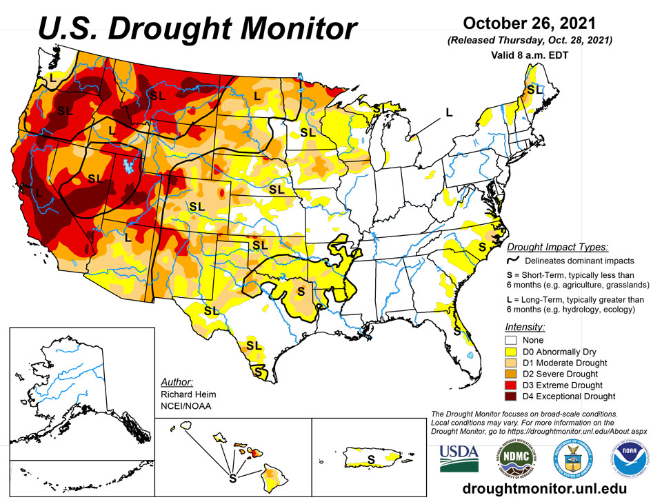
October 28, 2021 - A series of strong Pacific weather systems moved across the contiguous U.S. (CONUS) during this U.S. Drought Monitor (USDM) week. The first system early in the week spread precipitation across Wyoming to the Upper Mississippi Valley, then left scattered showers over the Northeast before moving off into the Atlantic. The second brought precipitation to northern California and the Pacific Northwest. Its surface low weakened as it crossed the Rockies, but it was re-energized over the Plains and generated precipitation across the central Plains, Great Lakes, and Northeast. The third system slammed into the West Coast near the end of the week. Fed by an atmospheric river of Pacific moisture, its surface low and front left heavy precipitation across California with widespread rain and some high elevation snow from California and the Pacific Northwest to the Great Basin. According to the National Weather Service Weather Prediction Center, as the third low pressure system approached the Pacific Northwest coast, it set a pressure record, testifying to the strength of the system. The October 24th pressure was 942.5 mb, which is a record low pressure for the Pacific Northwest. The end result of these weather systems was above-normal precipitation for the week across much of the West, including the Pacific Northwest, California, Nevada, and the central to northern Rocky Mountains; across eastern portions of the northern and central Plains, the southern Great Lakes, and western and southern portions of the Northeast; and a band of precipitation from southeast Kansas to eastern Kentucky. The precipitation improved short-term conditions, especially in the West, with soil moisture, streamflow, and 1-month to 6-month Standardized Precipitation Index (SPI) indicators sliding into the wet categories. Other drought indicators, such as vegetation-based VHI and VegDRI, were slower to respond. Groundwater, reservoir levels, and longer-term (9-month to 72-month) SPI indicators still indicated very dry long-term drought conditions in the West and northern Plains. The rest of the CONUS was drier than normal, with little to no precipitation falling across much of the Southwest, central and southern Plains, Lower Mississippi Valley to Southeast, northern reaches of the Upper Mississippi Valley, and northern Maine. Weekly temperatures were warmer than normal in the Pacific Northwest to northern and central Rockies, the southern Plains to Gulf of Mexico coast, and along the eastern seaboard. Temperatures averaged cooler than normal in California and the northern Plains to Upper Mississippi Valley. Drought contracted or was reduced in intensity in parts of the West and Midwest, but expanded or intensified in the southern Plains, central High Plains, and Southeast.
Northeast
Half an inch to 2 inches of precipitation fell across much of the Northeast this week, with locally heavier amounts across New Jersey and southern New York. But lesser amounts fell across the drought areas in the north. Enough rain fell to prevent drought development or expansion, but not enough fell to contract existing drought areas.
Southeast
Frontal rains left half an inch to locally 2 inches of precipitation across parts of Virginia and a few areas of North Carolina, while showers peppered parts of Florida with up to half an inch of rain. But large parts of the Carolinas, Georgia, and eastern Florida were dry, with the dry conditions extending to the last 2 to 3 months. D0 (abnormally dry conditions) expanded in the Carolinas, Georgia, and southern parts of Virginia, and were introduced in Florida. D1 (moderate drought) was added to eastern North Carolina where groundwater levels have dropped below normal, including a continued decline this week at the Simpson well in Pitt County. There have also been repeated reports of agricultural impacts in recent weeks from Craven County indicating dry conditions there. Fire danger was also elevated in that region. According to U.S. Department of Agriculture (USDA) reports, 41% of the topsoil moisture in North Carolina was short or very short of moisture (dry to very dry), with 34% so rated in South Carolina and 28% in Georgia.
South
Temperatures were hot this week in the South, with some record high temperatures recorded in Louisiana. Parts of northern Tennessee received an inch or more of precipitation, and patches of half an inch occurred over parts of central Arkansas, southern Mississippi, and coastal southeast Texas. Otherwise, most of the South received no precipitation this week. Drying soils and vegetation prompted expansion of D0 and D1 from the ArkLaTex region to west-central Mississippi. D0, D1, and D2 (severe drought) expanded in parts of eastern, northern, and southern Texas.
Midwest
Much of the southern and central portions of the Midwest received heavy precipitation, with a band of 2 to locally 4 inches measured from Iowa and northeast Missouri to southern Michigan and northwest Ohio. Areas to the south and north had 0.5 to 2.0 inches, except for a dry spot in southeast Minnesota to central Wisconsin and a dry swath in central Missouri. The northern half of Minnesota received no precipitation. D0 to D2 contracted in Iowa and Illinois, D0-D1 were reduced in Missouri, and D0 was shaved in southwest Minnesota. But D0 and D1 expanded in parts of Wisconsin.
High Plains
Half an inch to an inch of rain was widespread across Wyoming and South Dakota to eastern Nebraska, with up to 2 inches falling across southeast Kansas. Otherwise, little to no precipitation occurred elsewhere in the High Plains region. D0 was trimmed in eastern Nebraska and D0-D1 trimmed in southeast Kansas. D1 and D3 (extreme drought) were reduced in Wyoming, and D2 and D3 contracted in western Colorado, but D0-D2 expanded in eastern, central, and southern Colorado. According to USDA statistics, 73% of the pasture and rangeland in North Dakota was in poor to very poor condition, with the statistics 78% in South Dakota, 55% in Wyoming, 49% in Colorado, 31% in Nebraska, and 26% in Kansas.
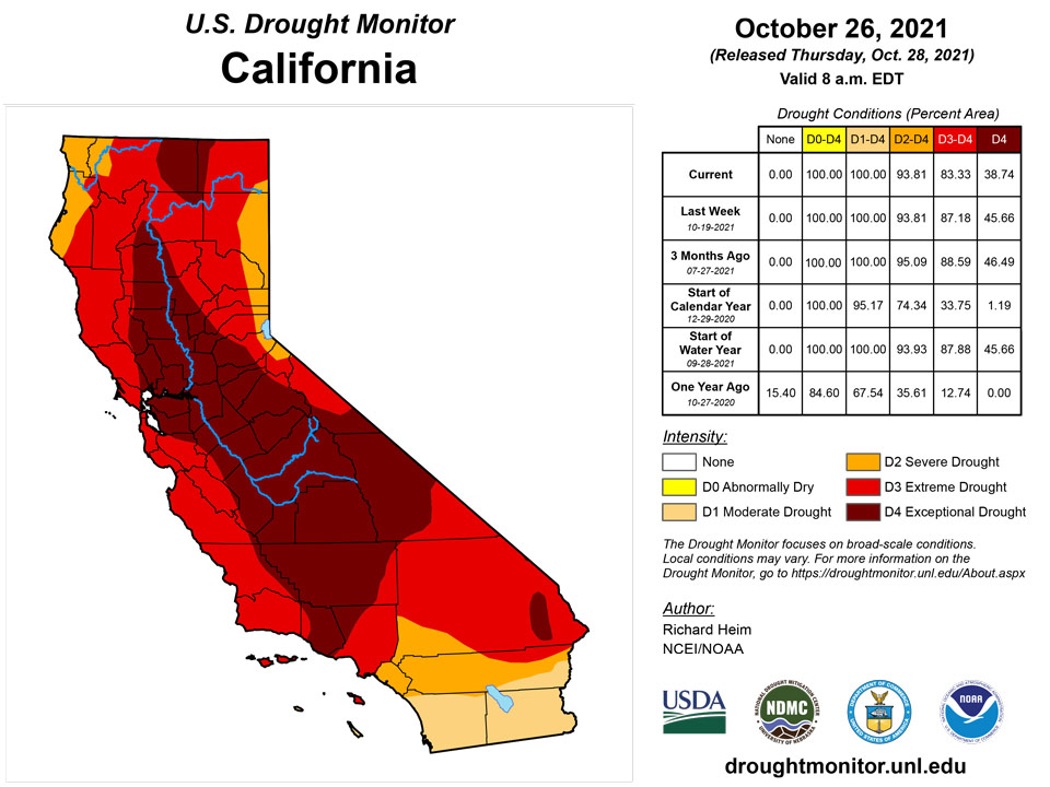
West
Two inches to over 10 inches of precipitation fell across the West from the coast to the Sierra Nevada and Cascade ranges, over 2 inches was widespread across central Idaho and in parts of Nevada and Utah, with over half an inch over the rest of the Pacific Northwest into southern California, most of Nevada, and western and northern sections of Utah. Less than half an inch to no precipitation fell over the deserts of southern California and southern Nevada, over southeast Utah, and most of Arizona. New Mexico and parts of Montana were dry this week. A volunteer observer west of Reno, Nevada, recorded 6.83 inches of precipitation from the storm, while South Lake Tahoe measured 7.07 inches for the USDM week. Some all-time daily precipitation records were broken October 24 in northern California. These include 5.44 inches at Sacramento City (breaks the previous record of 5.28 inches from April 20, 1880), 5.41 inches at Sacramento Exec Airport (previous record was 3.77 inches on October 13, 1962), and 10.40 inches at Blue Canyon (exceeded the previous record of 9.33 inches from December 22, 1964). The heavy rains which fell over a short period of time resulted in transient rises on local creeks, ponding of water, mud and rock slides, and some debris flows over recent burn areas. So much rain falling so quickly likely mostly ran off and had little chance to soak into the soil. But the rain wetted the soils prior to the building of the winter snowpack which will help in the future. While beneficial, the precipitation improved hydrological conditions only marginally. In the Sacramento area, there were limited inflows into the major flood control and water storage reservoirs, which remain well below normal storages. The water level at Lake Tahoe rose only about 7 inches. In southern California, Big Bear Lake was two feet away from the record level of 18 feet below, and avocado production was reduced roughly 22% in the southern California growing belt.
Topsoil moisture improved considerably from the rains this week, according to USDA statistics. California went from 75% of the topsoil moisture short or very short last week to 40% this week, Oregon improved 16% to 53% short or very short this week, Washington improved 9% to 78%, and Idaho improved 17% to 45%. But Montana still had 96% of the topsoil moisture short or very short. The rain was not enough to replenish significantly low reservoirs. From October 21 to 26, reservoirs rose very little. Some examples for larger reservoirs: in Idaho, American Falls reservoir went from 15% full to 17% full, while Palisades stayed at 6% full; in California, Shasta rose from 21% of total capacity to 22%, Lake Oroville from 22% to 27%, Trinity Lake from 26% to 27%, and Folsom rose from 22% to 31%; in Oregon, Wickiup went from 4% full to 7%, while Owyhee stayed at 11%; and in Washington, Cle Elum went from 21% full to 22%.
D3 and D4 (exceptional drought) were pulled back in northern California, northwest Nevada, and parts of Idaho where the heaviest rains fell; D0, D3, and D4 contracted in Washington; and D3 and D4 contracted in Montana. The contraction of D3-D4 in eastern Montana reflected cumulative effects of above-normal precipitation over the last 2 to 4 weeks. However, D4 expanded along the east slopes in western Montana and D3 expanded in north central Montana to reflect intensifying dry conditions over the last 2 months.
Caribbean
The USDM status in Puerto Rico remained unchanged from last week.
St. Thomas had 1.19 inches at the Cyril E. King Airport this week, while rainfall totals ranged between 0.10 - 0.40 inches across the different CoCoRaHS stations in the region. The airport’s month-to-date rainfall total of 2.77 inches was 63.2% of normal, while the month-to-date rainfall totals across the CoCoRaHS stations were 1.91 to 4.46 inches. The year-to-date rainfall total at the airport was 80.7% of normal. The SPI value at the 1 month period was indicative of abnormally dry conditions, while the 3, 6, 9, and 12 month periods were indicative of drought free conditions. For this week, drought free conditions persisted across St. Thomas.
Drought free conditions persisted across St. John this week. Following a very wet week, St. John had between 0.51 to 0.86 inches of rain this week at the different CoCoRaHS stations. The month-to-date rainfall total at the Windswept Beach was 179.6% of normal. SPI values at all time periods were also indicative of drought free conditions.
Meanwhile, St. Croix continued to be in long-term moderate drought. The Henry E. Rohlsen airport had 0.58 inch of rain, while rainfall totals varied from 0.28 to 1.51 inches across the different CoCoRaHS stations. The month-to-date rainfall total at the airport was 109.4% of normal and 70.2% of normal for the year-to-date. SPI values at the 1 month period was indicative of drought free conditions, while the 3, 6, 9, and 12 month periods were indicative of abnormally dry conditions to severe drought.
Pacific
The USDM status in Hawaii remained unchanged from last week. In Hawaii, the week was generally dry with a lighter wind pattern. Streamflow was generally near to above normal.
The USDM status in Alaska remained unchanged from last week. Alaska was generally drier and warmer than normal this week. There is some dryness in the Cook Inlet region during the last 1 to 4 months, but not enough to warrant a drought or abnormally dry classification.
Palau had only 1.04 inch of rain for the week, which is below the threshold of 2 inches to meet most water needs. However, drought free conditions continued since Palau’s month-to-date rainfall total surpassed 25 inches.
The Marianas continued to be drought free since all three locations had over 1 inch of rain this week and over 8 inches for the month to meet most water needs. Guam had the most rain this week with close to 9 inches, which was mainly due to Tropical Storm Malou that formed about 490 miles west-northwest of Guam.
Across the Federated States of Micronesia, Yap, Kosrae, Nukuoro, and Kapingamarangi had little to no rain this week. This week marked Kapingamarangi’s second consecutive week with no rain and third consecutive week with rainfall totals less than half an inch, resulting in only 1.46 inches of rain for the month so far. Locals reported that vegetation was browning on the atoll and water catchments were around 25%. Based on recent rainfall totals and impacts, Kapingamarangi’s drought classification was changed to short- and long-term severe drought. Similarly, Nukuoro had 0.17 inch of rain or no rain for the last three weeks and the month-to-date rainfall total was 4.67 inches, which is less than the threshold of 8 inches to meet most water needs. For this reason, short-term abnormally dry conditions were introduced this week. Kosrae had 0.37 inch of rain; however, its month-to-date rainfall total was close to 12 inches, securing another week of drought free conditions. Meanwhile, Chuuk, Lukunor, Pohnpei, Pingelap, Ulithi, and Woleai continued to be drought free since they received either 2 inches of rain this week or their month-to-date totals were over 8 inches.
The Marshall Islands received enough rain to continue drought free. Mili had the least rain this week at 0.80 inch, but continued to be drought free since its month-to-date rainfall total was over 11 inches.
Drought was not a concern across American Samoa. While Siufaga Ridge and Toa Ridge had over 1 inch of rain this week, Pago Pago had the least rain at 0.35 inch for the week. However, the month-to-date was over the threshold of 4 inches for all three locations.
Looking Ahead
A frontal low pressure system will complete its trek across the central to eastern CONUS during the next USDM week. For October 26-November 2, up to 3 inches of precipitation is expected from the eastern edge of the Plains to the Mississippi Valley, in parts of the Mid-Atlantic region, and along coastal New England, with 1 to 2 inches widespread in the South, Southeast, and Ohio Valley. Coastal Washington and northwest Oregon could receive 1 to over 5 inches, while the northern Rockies may receive a couple inches of precipitation. Much of the West outside of the Pacific Northwest and northern Rockies, western parts of the Great Plains, and the northern Great Lakes should receive little to no precipitation. Temperatures are expected to average near to above normal. The outlook for November 2-6 shows drier-than-normal weather favored over the Southwest and Upper Mississippi Valley, with wetter-than-normal weather favored from the Pacific Northwest to southern Plains and eastward to the East Coast (except New England). Odds favor colder-than-normal weather for most of the CONUS east of the Rockies. The outlook shows drier-than-normal weather in northeast Alaska and wetter than normal in the south, with warmer-than-normal temperatures for most of the state.
Author(s):
Richard Heim, NOAA/NCEI
Ahira Sanchez-Lugo, NOAA/NCEI
Dryness Categories
D0 Abnormally Dry—used for areas showing dryness but not yet in drought, or for areas recovering from drought.
Drought Intensity Categories
D1 Moderate Drought
D2 Severe Drought
D3 Extreme Drought
D4 Exceptional Drought
Drought or Dryness Types
S Short-term, typically less than 6 months (agriculture, grasslands)
L Long-term, typically more than 6 months (hydrology, ecology)
SL Area contains both short- and long-term impacts
Source: National Drought Mitigation Center
