


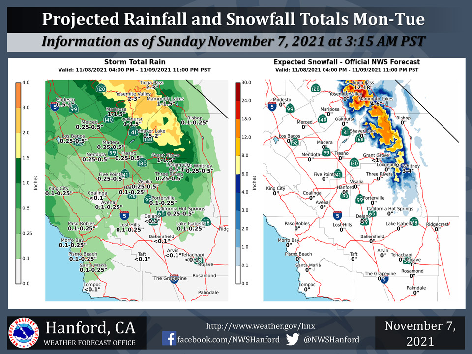
Projected rainfall totals for Mariposa: 1.00" to 1.50"
Projected rainfall totals for Oakhurst: 1.00" to 1.50"
Projected rainfall totals for Yosemite Valley: 2.00" to 3.00"
November 7, 2021 - The National Weather Service Hanford Office reports a storm system will bring valley rain and mountain snow to the forecast area Monday afternoon through Tuesday evening.Area Forecast Discussion National Weather Service Hanford CA 149 AM PST Sun Nov 7 2021 .SYNOPSIS... A storm system will bring rain and high Sierra snow to the areas mainly north of Kern County Monday night through Tuesday evening. The remainder of next week will be dry with mild afternoons along with areas of night and morning fog in the San Joaquin Valley. && .DISCUSSION... The forecast area remains just south of the main storm track early this morning with some high clouds streaming across the north while over parts of Kern, Tulare and Kings Counties low level stratus clouds are swirling around in the trapped moisture. To add a little spice to the cloud mix this morning, a line of upslope clouds extends along the Sierra crest from near Florence Lake to Tioga Pass. Any precipitation that may be falling is rather light and regional radars are not showing much echo activity. In the bigger picture, water vapor imagery shows the frontal band continues to push ever so slowly southward from the Bay area and thin as the tail end moves ashore. Any precipitation that may fall from this weak frontal system will occur during the next few hours. Meanwhile, out over the Pacific, the next weather disturbance is well noted out along 35N/135 as it rounds the base of a synoptic scale trough. Forecast models bring this feature ashore on Monday night and bring the bulk of precipitation to the forecast area Monday night through Tuesday evening. Forecast track from the latest deterministic models and the past several runs of the NBM (National Blend of Models) ensemble show the precipitation will stay generally north of Kern County with the greatest amount expected over Merced County in the San Joaquin Valley and in the Sierra from Sequoia and Kings Canyon Park northward. Yosemite looks to have the best chance of significant precipitation and the NBM probabilistic output gives Yosemite Valley a 45 percent chance of 1.00" of rain and a 32 percent chance of 1.50". In the San Joaquin Valley, the same probabilistic output for 0.25" is Merced: 39% on Monday and 55% on Tuesday Fresno: 18% on Monday and 39% on Tuesday Percentages drop quickly as you get farther south. For 0.10" of rain, Merced: 46% on Monday and 67% on Tuesday Fresno: 32% on Monday and 57% on Tuesday Visalia:19% on Monday and 43% on Tuesday Areas south of Kings and Tulare county look to stay dry with Bakersfield showing just a hundredth or two of expected precipitation at best due to the northerly path of the system. On Wednesday a strong ridge of high pressure is projected to begin building off the coast of Baja California and remain anchored in place through at least next weekend. This will bring a prolonged period of dry weather, above normal temperatures and patchy (or areas) of fog in the San Joaquin Valley. && .AVIATION... A few patches of MVFR ceiling along the Sierra Nevada Foothills and Kern County Mountains until 18z today. Otherwise, VFR conditions will prevail elsewhere over the central California interior during the next 24 hours. && .AIR QUALITY ISSUES... On Sunday November 7 2021... Fireplace/Wood Stove Burning Status is: No Burning Unless Registered in Fresno... Kern... Madera and Tulare Counties. Further information is available at Valleyair.orgSource: NWS
