


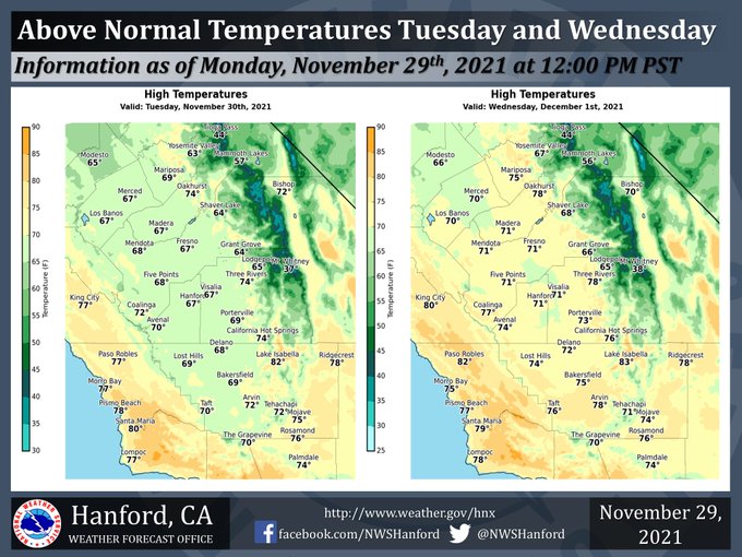
Mariposa projected high temperature for Tuesday: 69 degrees, Wednesday: 75 degrees
Oakhurst projected high temperature for Tuesday: 74 degrees, Wednesday: 78 degrees
Yosemite Valley projected high temperature for Tuesday: 63 degrees, Wednesday: 67 degrees
November 29, 2021 - The National Weather Service Hanford Office reports high temperatures in Central California Tuesday afternoon will be six to eight degrees above normal for this time of year.
Max temperatures in Central California Wednesday afternoon will be eleven to thirteen degrees above their typical values for the start of December.
  Area Forecast Discussion
  National Weather Service Hanford CA
  851 AM PST Mon Nov 29 2021

  .SYNOPSIS...
  Patchy, dense fog is possible in the western portion of the San
  Joaquin Valley, north of Kern County, late tonight into Tuesday
  morning. High temperatures will remain above their typical values
  for late November and early December, peaking at around ten
  degrees above normal each afternoon Wednesday through Friday. Dry
  weather will persist through at least Sunday night, if not longer.

  &&

  .DISCUSSION...
  Patchy, dense fog is conceivable in the western part of the San
  Joaquin Valley, north of Kern County, late tonight into Tuesday
  morning. A cyclone aloft will remain just offshore of the Baja
  Peninsula this week. Farther north, an upper-level area of high
  pressure will be centered near Northern California this week. This
  is what is called a Rex Block pattern, which results in very
  little fluctuations in the day to day weather. High temperatures
  throughout Central California Tuesday afternoon will be six to
  eight degrees above normal for this time of year. Maximum
  temperatures across Central California Wednesday afternoon,
  Thursday afternoon, and Friday afternoon will be around ten
  degrees above their typical values for the beginning of December.

  The aforementioned cyclone aloft should move to the east-northeast
  into the Desert Southwest late this week into the upcoming
  weekend. Be that at it may, that upper-level area of low pressure
  will be replaced by another cyclone aloft in the Eastern Pacific
  Ocean, reinforcing the Rex Block pattern in place. A downward
  temperature trend is expected Saturday through Monday. Despite
  this trend, high temperatures throughout Central California Sunday
  afternoon and Monday afternoon will be around five degrees above
  normal for this time of year. Dry weather will persist through at
  least Sunday night.

  &&

  .AVIATION...
  VFR conditions will prevail across Central California through at
  least 05z. MVFR visibilities are likely in the San Joaquin Valley
  after 05z due to fog. Patchy, dense fog is possible in the western
  portion of the San Joaquin Valley, north of Kern County after
  12z, which would result in LIFR conditions.

  &&

  .AIR QUALITY ISSUES...
  On Monday, November 29th, 2021, unhealthy for sensitive groups in
  Fresno, Kern, and Kings Counties. Fireplace/wood stove burning
  status is: no burning unless registered in Kings, Madera, Merced,
  and Tulare Counties. No burning for all in Fresno and Kern
  Counties. Further information is available at Valleyair.org.
Source: NWS
