


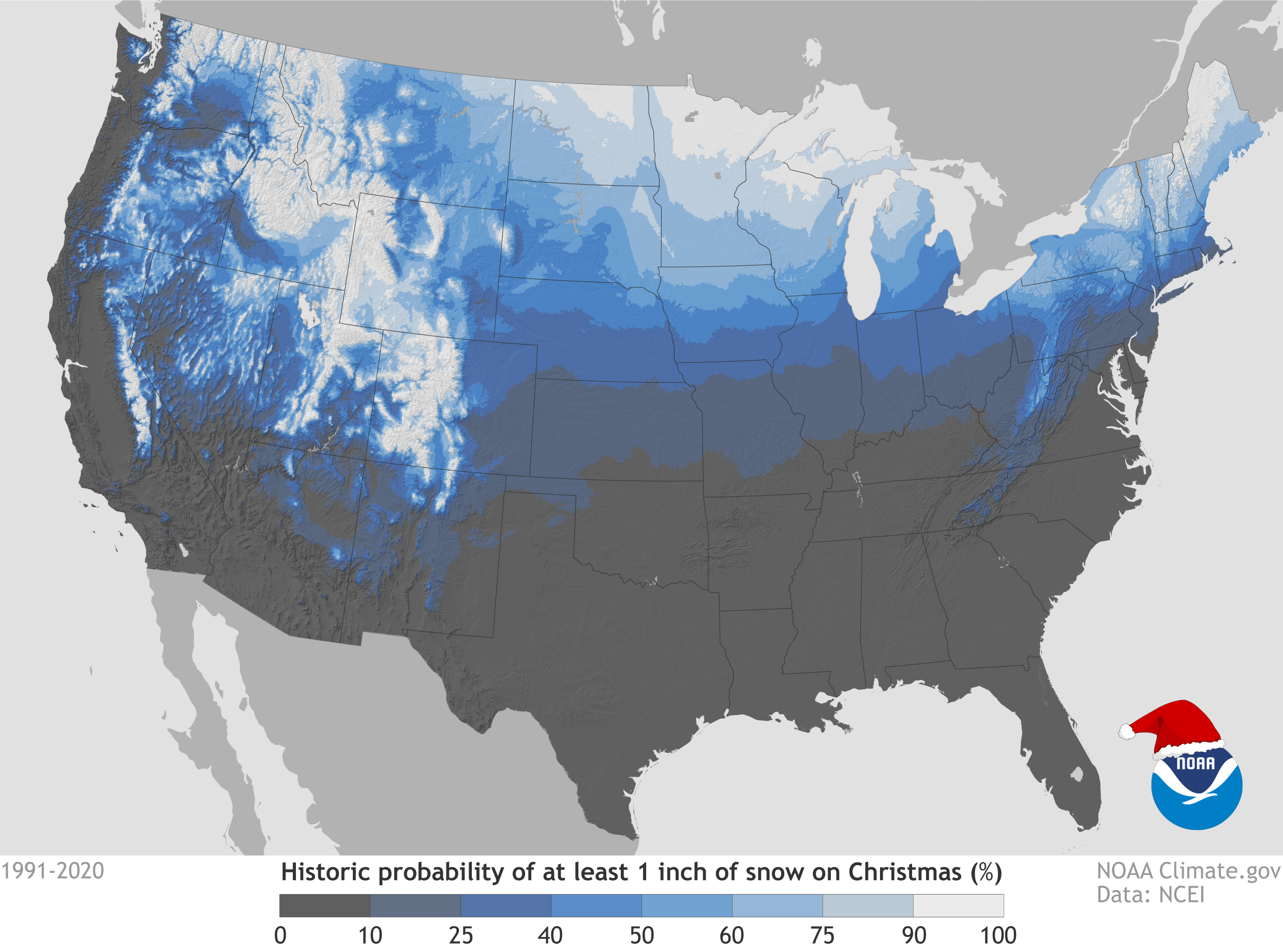
December 10, 2021 - For those of you dreaming of a white Christmas, you can find places that have the best chance of being a winter wonderland according to weather history. The “Historical Probability of a White Christmas” map shows the climatological probability of at least 1 inch of snow being on the ground December 25 in the contiguous United States. On the map, dark gray shows places where the probability is less than 10 percent, while white shows probabilities greater than 90 percent.
Crested Butte, Colorado, is just one of about a handful of weather stations boasting a nearly 100 percent historical probability of seeing a white ChristmasWhere does history say you should be in the Lower 48 states for the best chance of seeing a white Christmas? Most of Idaho, Minnesota, Maine, Upstate New York, the Allegheny Mountains of Pennsylvania and West Virginia, and, of course, the Rockies and the Sierra Nevada Mountains all have a high probability of seeing a white Christmas. And, Crested Butte, Colorado, is just one of about a handful of weather stations boasting a nearly 100 percent historical probability of seeing a white Christmas.
Snowy Climates Based on Data
This map is based on the 1991–2020 Climate Normals, which are the latest three-decade averages of several climatological measurements. Among the many parameters available at hourly to annual time periods, this collection contains daily and monthly Normals of temperature, precipitation, snowfall, heating and cooling degree days, frost/freeze dates, and growing degree days calculated from observations at approximately 15,000 stations operated by NOAA National Weather Service and its partners. You can find the Climate Normals for locations near you by using NCEI’s interactive map or search tool.
The new Climate Normals for 1991–2020 were issued by NCEI in May 2021The new Climate Normals for 1991–2020 were issued by NCEI in May 2021. The United Nations’ World Meteorological Organization (WMO) requires the calculation of normals every 30 years. However, many WMO members, including the United States, update their normals at the completion of each decade.
These probabilities are useful as a guide only to show where snow on the ground is more likelyWhile the map shows the climatological probability of snow-covered ground on December 25, the actual conditions this year may vary widely from these probabilities because the weather patterns present will determine if there is snow on the ground or if snow will fall on Christmas Day. These probabilities are useful as a guide only to show where snow on the ground is more likely. For prediction of your actual weather conditions, check out your local forecast at Weather.gov within seven days of Christmas.
For a full list of stations and their historic probabilities for an inch of snow on Christmas day, download our spreadsheet.
Tracking U.S. Snowfall
If you would like to keep track of the snowfall across the United States on a daily basis, see the National Operational Hydrologic Remote Sensing Center’s National Snow Analyses.
Daily snow depth and snowfall extremes for U.S. locations are available from our Snow and Ice monitoring page. Monthly snow cover images from satellite data are available from Rutgers Snow Lab back to the late 1960s.
Related Links
Source: NOAA
