


California and National Drought Summary for December 28, 2021
Summary
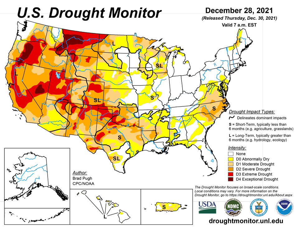
December 30, 2021 - A persistent pattern over the North Pacific and western North America maintained a continuation of frequent storms affecting the West Coast through late December. 7-day precipitation from December 21-27 exceeded 2 inches, liquid equivalent, across much of California along with western portions of Oregon and Washington. During the past two weeks, precipitation has averaged 150 to 300 percent of normal, or more, throughout nearly all of California. This wet pattern during mid to late December has also been accompanied by below normal temperatures (-2 to -6 degrees F) across California and the Pacific Northwest. Periods of heavy snow continue to build a favorable snowpack from the Cascades southward to the Sierra Nevada Mountains. On December 23 and 24, a strong low pressure system tracked inland from the East Pacific and resulted in widespread precipitation of 0.5 to 3 inches, liquid equivalent, across much of southern California along with the Great Basin, Southwest, and Four Corners region. Dry weather with much above normal temperatures persisted throughout the central and southern Great Plains. As of December 28, month-to-date temperatures have averaged more than 7 degrees F above normal across the south-central U.S. Eastern North Dakota and the upper Mississippi Valley received another round of precipitation (0.25 to 0.75 inches, liquid equivalent) this past week. Following a period of widespread rainfall across much of the Ozarks region, lower Mississippi Valley, and Southeast during mid-December, dry weather returned to these areas from Dec 21 to 27. Little or no precipitation continued through late December across the Mid-Atlantic. The wet pattern, typical of La Nina winters, continues to affect Hawaii.
Northeast
Based on increasing short-term precipitation deficits, 60-day SPI values, 28-day average streamflows, and declining soil moisture, moderate drought (D1) was expanded across eastern West Virginia. Elsewhere, abnormal dryness continues across the northern Mid-Atlantic where 60-day precipitation deficits range from 2 to 6 inches.
Southeast
A slight expansion of moderate drought (D1) was made to northern and western parts of Virginia based on increasing short-term precipitation deficits along with soil moisture and 28-day average streamflows. A dry week and increasing short-term precipitation deficits resulted in a slight expansion of abnormal dryness (D0) across parts of Alabama, Georgia, and the Florida Panhandle. Areas of Georgia that received more than 2 inches of rainfall during the previous week were not included in this D0 expansion.
South
Based on persistent dryness, periods of enhanced winds and anomalous warmth this month, and worsening soil moisture conditions, a broad 1-category degradation was made to much of Oklahoma and the Texas Panhandle. Most locations across southwestern Oklahoma along with the Oklahoma and Texas Panhandles have received less than 0.10 inch of precipitation during the past 70 to 80 days. As of December 28, Amarillo, Texas has observed no precipitation for 76 consecutive days which is the second longest dry streak on record. Additional expansion of various Dx levels was also made across much of the remainder of Texas due to persistent dryness and much above normal temperatures. Month-to-date temperatures, as of December 28, have averaged more than 8 degrees F above normal throughout nearly all of Oklahoma and Texas. The current depiction of conditions across Arkansas, Louisiana, and Mississippi was a balance among SPI values, soil moisture, and 28-day average streamflows. During the past 90 days, precipitation has averaged less than 50 percent of normal throughout much of the lower Mississippi Valley.
Midwest
Another week of widespread precipitation (more than 0.5 inch, liquid equivalent) along with positive SPI values dating back 6 months supported a slight decrease in abnormal dryness (D0), moderate drought (D1), and severe drought (D2) across parts of Minnesota. However, there are continued long-term precipitation deficits for parts of the upper Mississippi Valley including International Falls, Minnesota which has a 5 inch deficit for 2021 as of December 28. A small improvement was also made to parts of western Wisconsin that received around 0.75 inches of precipitation this past week. Based on 120-day SPI, moderate (D1) to severe (D2) drought was expanded slightly across southern Wisconsin. Increasing short-term deficits resulted in a slight expansion of abnormal dryness (D0) across parts of Missouri. A small area of severe drought (D2) was added to the west of St Louis based on short-term SPIs and 28-day streamflows.
High Plains
A continued expansion of abnormal dryness (D0), moderate drought (D1), and severe drought (D2) were required again this week across much of Kansas due to worsening soil moisture indicators, 90 to 120-day SPIs, declining streamflows, and impacts such as cattle sell-offs. A 1-category degradation was made to the southwest corner of Nebraska based on soil moisture and SPI values at various time scales. A recent increase in snowpack led to improving drought conditions across the central Rockies, to the west of the Continental Divide. Severe (D2) to extreme (drought) was expanded across northeast Colorado due to declining soil moisture indicators and EDDI. Precipitation (more than 0.5 inch, liquid equivalent) on Dec 26 along with positive SPI values dating back 6 months supported a slight decrease in abnormal dryness (D0) and moderate drought (D1) across central and eastern North Dakota.
West
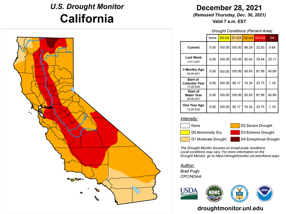
Heavy December precipitation, SWE numbers, and 12 to 24-month SPIs supported a large 1-category improvement to California along with parts of Nevada and Utah. The SWE is 150 to 250 percent of normal throughout the Sierras for this time of year. The Central Sierra snow lab has observed 193.7 inches of snowfall this month which is a December record. 179 inches, set in 1970, was the previous record for December. As of December 28, the California statewide average of snow water content is 159 percent of normal for that date. Given the favorable snowpack and heavy precipitation during December, additional improvements may be warranted for California during subsequent weeks. Widespread, heavy precipitation (1 to 3 inches, liquid equivalent) resulted in a 1-category improvement across parts of Arizona and Utah where the heaviest amounts occurred and also supported by 12-month SPI values. A 1-category improvement was also made to much of northern and central Idaho along with adjacent areas of northwest Montana based on near to above normal SWE and 24-month SPI. A sharp gradient in drought conditions exists from west to east along the Continental Divide. During the past 14 days, parts of southeast Washington and northeast Oregon have received more than 2 inches of precipitation, liquid equivalent. This recent heavy precipitation and favorable response from soil moisture and 28-day streamflow indicators prompted a slight improvement to those areas. The longer term SPEI, which includes the record heat earlier this summer, continues to support extreme (D3) to exceptional (D4) drought for central and eastern parts of Oregon and Washington. Along and to the west of the Cascades, additional improvements were made this week to western Oregon. A recent increase in snowfall prompted improving drought conditions across parts of northern New Mexico, while all of northeast New Mexico is now designated with severe (D2) to extreme (D3) drought. No precipitation has been observed at Clayton, New Mexico for 76 days which is the 5th longest streak on record.
Caribbean
No changes were made to Puerto Rico as 14-day precipitation has averaged at or below normal for areas that are currently designated with abnormal dryness (D0) or moderate drought (D1).
There are no changes to the U.S. Virgin Islands’ drought depiction: D3-SL on St. Croix; D2-SL on St. Thomas; and D1-SL on St. John. During the latest drought-monitoring period, dry-season conditions became deeply entrenched across the territory, with volunteer (CoCoRaHS) observers reporting 7-day totals ending the morning of December 28 ranging from 0.00 to 0.09 inches. Through December 28, month-to-date rainfall at the major airport observation sites stood at 1.41 inches (52% of normal) at King Airport on St. Thomas and 1.18 inches (39%) at Rohlsen Airport on St. Croix. To avoid experiencing its driest year on record (21.61 inches in 2002), Rohlsen Airport will need to receive rainfall totaling more than 0.15 inch during the last 3 days of 2021. Meanwhile, groundwater data from the U.S. Geological Survey continues to show a modern-day record depth to water at the Adventure 28 Well on St. Croix – 29.10 feet by December 29 and increasing daily. Depth to water at that St. Croix well has increased more than 10 feet in 2021.
Pacific
Another week of wet weather, associated with enhanced trade winds, resulted in a 1-category improvement statewide across Hawaii. 28-day streamflows are generally running at or above normal due to the continued wet pattern during December. Long-term drought (D1) is now only designated for parts of Maui and Molokai.
Alaska remains drought-free with unusually heavy precipitation affecting central interior Alaska during late December. On December 26, Fairbanks received 1.93 inches of precipitation, liquid equivalent, which is the wettest December day on record.
A dry-season pattern has moved into place across the Mariana Islands (CNMI), as well as portions of the Marshall Islands (RMI). In the RMI, D0-S was introduced a week ago for Wotje, where no rain has fallen for more than 3 weeks. Unless rain returns across Wotje, drought will soon develop. Elsewhere in the RMI, there is neither dryness nor drought. However, Kwajalein has been mostly dry since December 13, when 1.49 inches fell; with reports that vegetation is becoming stressed, the atoll is on the verge of experiencing short-term dryness. Meanwhile, Majuro has been relatively wet, with 8.76 inches reported for December through the 28th. However, water storage on Majuro fell from 30.743 to 23.836 million gallons (from 85 to 66% of capacity) between December 8 and 27. Across the CNMI, it has been generally dry for 3 weeks, following a protracted wet spell from the late-summer months into early December. Guam International Airport has been one of the driest of the CNMI locations, with less than 0.50 inch of rain reported each of the last 3 weeks. As a result, Guam and other locations in the Marianas will be closely monitored for the need to introduce abnormal dryness.
In recent days, dry weather has extended southward into northern reaches of the Federated States of Micronesia (FSM), while a near-equatorial trough has maintained showery conditions across Yap and the Republic of Palau. In fact, month-to-date rainfall through December 28 totaled approximately 12 to 16 inches at all reporting sites in the Republic of Palau, except Peleliu, per National Weather Service reports. In contrast, Chuuk Lagoon’s rainfall during the December 22-28 drought-monitoring period totaled just 0.01 inch, following amounts ranging from 1.50 to 7.60 inches during each of the preceding 10 weeks. Most other sites in the FSM remain relatively wet, except Kapingamarangi, where severe drought (D2-SL) persists. Woleai was again set to “missing,” as regular rainfall data has not been received since early December.
November was quite wet in American Samoa, with more than 15 inches of rain reported at Pago Pago International Airport. December has been a bit drier, with 7.44 inches falling at the airport through the 28th. However, dryness is not yet pervasive of long-lasting enough for significant concern, although the trend will be monitored by drought scientists. In the last week, American Samoa’s two National Park Service observation sites – Siufaga Ridge and Toa Ridge – reported weekly rainfall totals of less than one-half inch.
Looking Ahead
Another round of heavy rain and high-elevation snow are forecast across southern California, the Southwest, and Four Corners region on Dec 30 and 31. A low pressure system and trailing front are expected to progress eastward from the central to eastern U.S. from Jan 1 to 2. A swath of snow may occur on the northwest side of the surface low track, from the central Plains northeast to the Midwest and Great Lakes. Heavy rain (1 to 3 inches) is forecast to overspread the Tennessee Valley, southern Appalachians, and southern Mid-Atlantic. Little to no precipitation is expected for the southern Great Plains into the beginning of the New Year. Heavy rain and high-elevation snow is forecast to return to the Pacific Northwest and northern California by Jan 3. Following a brief moderation in temperatures, another outbreak of Arctic air is anticipated to shift south from Canada into the northern Plains during the first week of January 2022. The wet pattern is likely to persist across Hawaii well into the New Year.
The Climate Prediction Center’s 6-10 day outlook (valid Jan 4-8, 2022) favors above-normal temperatures across the southern Great Plains, Gulf Coast States, and along the East Coast. Below-normal temperatures are very likely for the northern Great Plains and southeastern Alaska where probabilities exceed 70 percent. Near or below-normal temperatures are favored throughout the West. Above-normal precipitation is most likely across the northern to central Rockies, Great Basin, Pacific Northwest, and northern California. Probabilities of above-normal precipitation are elevated from the Mississippi Valley to the East Coast, while below-normal precipitation remains favored for the southern Great Plains.
Author(s):
Brad Pugh, NOAA/CPC
Brad Rippey, U.S. Department of Agriculture
Dryness Categories
D0 Abnormally Dry—used for areas showing dryness but not yet in drought, or for areas recovering from drought.
Drought Intensity Categories
D1 Moderate Drought
D2 Severe Drought
D3 Extreme Drought
D4 Exceptional Drought
Drought or Dryness Types
S Short-term, typically less than 6 months (agriculture, grasslands)
L Long-term, typically more than 6 months (hydrology, ecology)
SL Area contains both short- and long-term impacts
Source: National Drought Mitigation Center
