


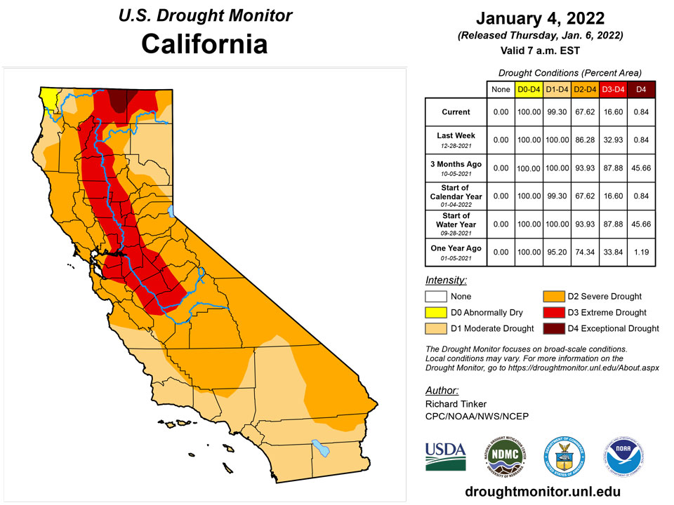
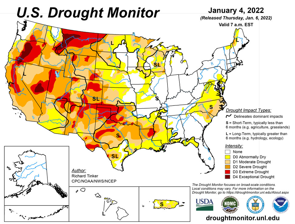
California and National Drought Summary for January 4, 2022
Summary
January 6, 2022 - In what has become a familiar pattern, heavy precipitation continued to improve drought and dryness across the northern half of the West Coast States, though it created its own set of significant impacts. Farther south, similar totals fell on a relatively small area in southwest California. Heavy precipitation – some falling as heavy snow – also covered areas from the Ohio Valley and Middle Atlantic States southward through the Tennessee Valley, the interior Southeast, and the Carolinas. Parts of the Rockies – primarily the higher elevations – also reported moderate to heavy precipitation. Meanwhile, only light precipitation fell on the Northeast, across much of the lower Midwest, and along most of the Gulf Coast and adjacent areas. Most of the Plains and upper Mississippi Valley reported little or no precipitation. The result was some significant areas of drought improvement across the Carolinas and interior Southeast, as well as parts of the West Coast States and Rockies. In contrast, unseasonably warm and dry weather for several weeks prompted fairly broad areas of deterioration along the immediate central Gulf Coast, the southwestern half of the lower Mississippi Valley, and the southern Plains.
Northeast
En lo que se ha convertido en un patrón familiar, las fuertes precipitaciones continuaron mejorando la sequía y la sequedad en la mitad norte de los estados de la costa oeste, aunque crearon su propio conjunto de impactos significativos. Más al sur, totales similares cayeron en un área relativamente pequeña en el suroeste de California. Las fuertes precipitaciones, algunas en forma de nieve intensa, también cubrieron áreas desde el valle de Ohio y los estados del Atlántico medio hacia el sur a través del valle de Tennessee, el interior del sureste y las Carolinas. Partes de las Montañas Rocosas, principalmente las elevaciones más altas, también informaron precipitaciones de moderadas a intensas. Mientras tanto, solo cayeron precipitaciones ligeras en el noreste, en gran parte del medio oeste inferior y en la mayor parte de la costa del Golfo y áreas adyacentes. La mayor parte de las llanuras y la parte superior del valle del Mississippi informaron poca o ninguna precipitación. El resultado fue algunas áreas significativas de mejora de la sequía en las Carolinas y el interior del sureste, así como en partes de los estados de la costa oeste y las Montañas Rocosas. Por el contrario, el clima inusualmente cálido y seco durante varias semanas provocó áreas bastante amplias de deterioro a lo largo de la costa central inmediata del Golfo, la mitad suroeste del valle inferior del Mississippi y las llanuras del sur.
Southeast
Most areas in the Southeast Region recorded moderate to heavy precipitation, though only light amounts dampened the immediate Gulf Coast, the southeastern half of Georgia, and Florida. Most of western South Carolina, northern Georgia, northeastern Alabama, and eastern Tennessee reported 3.5 to locally 6 inches of precipitation. Locations across the immediate Ohio Valley, Farther north and east, from most of Virginia southward into southern Georgia, received 2 to locally 4 inches of precipitation, but across northern and central Virginia, much of this fell as heavy snow. Between 10 and 16 inches buried areas from the southern suburbs of Washington, DC and central Virginia. This heavy precipitation resulted in a large area of 1-category improvements from central Virginia southward across the interior Carolinas and most of the extant dry areas in Georgia. Only small areas along the immediate Gulf Coast from southernmost Alabama to the eastern Florida Panhandle – which missed the heavy precipitation – deteriorated.
South
La mayoría de las áreas en la región sureste registraron precipitaciones de moderadas a fuertes, aunque solo cantidades ligeras humedecieron la costa del Golfo, la mitad sureste de Georgia y Florida. La mayor parte del oeste de Carolina del Sur, el norte de Georgia, el noreste de Alabama y el este de Tennessee informaron de 3,5 a localmente 6 pulgadas de precipitación. Las ubicaciones en todo el valle inmediato de Ohio, más al norte y al este, desde la mayor parte de Virginia hacia el sur hasta el sur de Georgia, recibieron de 2 a localmente 4 pulgadas de precipitación, pero en el norte y centro de Virginia, gran parte de esto cayó en forma de nieve intensa. Áreas enterradas de entre 10 y 16 pulgadas de los suburbios del sur de Washington, DC y el centro de Virginia. Esta fuerte precipitación resultó en una gran área de mejoras de categoría 1 desde el centro de Virginia hacia el sur a través del interior de las Carolinas y la mayoría de las áreas secas existentes en Georgia. Solo se deterioraron pequeñas áreas a lo largo de la costa del Golfo inmediata desde el extremo sur de Alabama hasta el este de Florida Panhandle, que no se vieron afectadas por las fuertes precipitaciones.
Midwest
Heavy precipitation was widespread across Kentucky and near the Ohio River, keeping those areas free from any dryness or drought. Moderate to heavy precipitation fell from the Ohio River northward across the lower Great Lakes region, with totals decreasing moving northward away from the Ohio River. As a result, D0 was removed from southwestern Illinois, and less-widespread improvement was brought into areas in and near northern Illinois, and across portions of Missouri. Meanwhile, the central and northern parts of the Great Lakes region and the upper Mississippi Valley- where no changes were introduced - received light precipitation, if any.
High Plains
It was a dry week east of the Rockies, and even across Colorado and Wyoming, moderate to heavy precipitation was limited to the higher elevations. This was sufficient to prompt some improvement in western Colorado and a small section in northwestern Wyoming. The eastern portions of D0 and D1 areas in North Dakota were also improved based on a re-assessment of reduced impacts from earlier precipitation. Meanwhile, southern Kansas saw some deterioration near Oklahoma, where the last 60 days brought very little precipitation. But given it is the coldest and climatologically driest time of year there, deterioration was limited to a patch in the southernmost reaches of Kansas where the weather has been somewhat warmer. Central Wyoming also saw worsening conditions where little or no precipitation fell during the last 60 days.
West
Fue una semana seca al este de las Montañas Rocosas, e incluso en Colorado y Wyoming, las precipitaciones de moderadas a fuertes se limitaron a las elevaciones más altas. Esto fue suficiente para provocar algunas mejoras en el oeste de Colorado y una pequeña sección en el noroeste de Wyoming. Las partes orientales de las áreas D0 y D1 en Dakota del Norte también se mejoraron en base a una nueva evaluación de los impactos reducidos de las precipitaciones anteriores. Mientras tanto, el sur de Kansas experimentó cierto deterioro cerca de Oklahoma, donde los últimos 60 días trajeron muy poca precipitación. Pero dado que es la época del año más fría y climatológicamente más seca, el deterioro se limitó a un área en el extremo sur de Kansas donde el clima ha sido algo más cálido. El centro de Wyoming también experimentó un empeoramiento de las condiciones en las que cayeron pocas o ninguna precipitación durante los últimos 60 días.
Caribbean
Light rains at best fell across Puerto Rico, keeping conditions essentially unchanged there.
Drought conditions remained unchanged in the U.S. Virgin Islands after another dry week. Moderate short- and long-term drought continued on St. John, where groundwater levels continued to drop. Short-term precipitation deficits are growing, and worsening to severe drought levels may occur soon if significant precipitation does not fall. Short- and long-term severe drought continued on St. Thomas, where groundwater remained low, and short- and long-term precipitation deficits continued. Extreme short- and long-term drought remained on St. Croix this week, where groundwater levels dropped further and large short- and long-term precipitation deficits continued.
Pacific
Drought continued to loosen its grip on Hawaii. Lessening impacts led to a second consecutive week with 1-category improvements across the board there. This left the island chain drought-free, and restricted abnormal dryness (D0) to the southern tier of Molokai and central Maui.
Alaska remained free of any drought or dryness.
Drought-free conditions continued on Palau this week, where rainfall totaled 1.95 inches at the airport and 2.3 inches at the Koror site.
Drought-free conditions continued this week in American Samoa. Pago Pago received 0.88 inches of rain, while 1.12 inches fell at Toa Ridge and 2.45 inches fell at Siufaga Ridge.
On Guam, 0.42 inches of rain fell this week, marking 4 consecutive weeks with less than a half an inch of rain. There, grasses have dried recently, and short-term abnormal dryness is being introduced. Rainfall gauges on Saipan measured 0.96 and 1.22 inches this week, which was on the wetter end of rainfall amounts from a relatively dry past several weeks. Rain on Rota totaled 1.59 inches this week, and drought-free conditions continued.
After 6.40 inches of rain fell this week at Kapingamarangi, on top of over 14 inches in December, drought conditions improved from severe to moderate drought. The drought designation was also changed to short term there, as rainfall deficits are comparatively more significant in the short term than the long term, despite the recent rainfall. Only 0.05 inches of rain have fallen in the last two weeks on Chuuk; given the very dry recent weather, short-term abnormal dryness is being introduced. Drought-free conditions continued on Yap and Ulithi this week. On Woleai, at least 2.84 inches of rain fell this week. Given recent missing data, though, no drought monitor depiction is being made there this week. Weather on Fananu and Lukunor this week was relatively dry, with no rain and 0.03 inches reported (with a few missing days). Given wet conditions before this week, though, both islands remain free of drought. Just below a half inch of rain fell on Nukuoro this week (with one day missing), which continued a general drying trend over the last several weeks. However, given that 3.7 inches of rain fell 3 weeks ago, Nukuoro remains free of drought. Pohnpei, Pingelap, and Kosrae all recorded less than an inch of rain this week (though with some data missing). Given wet Decembers at all three locations, though, each remains free of drought.
Short-term abnormal dryness developed on Kwajalein this week, where a quarter inch of rain fell this week, continuing a recent dry spell. Short-term moderate drought developed on Wotje after a fourth consecutive dry week. There, water levels have been declining and vegetation has been browning. Only 0.13 inches of rain fell on Ailinglapalap this week, but this drier weather came on the heels of 2.38 inches last week, so drought-free conditions continued. Only 0.23 inches of rain fell on Jaluit this week, but this followed a very wet December, when over 17 inches of rain fell. Only 0.55 inches of rain fell on Majuro this week, which marked the third consecutive week with less than 2 inches of rain. However, given over 8 inches of rain in December, the conditions have not quite reached abnormally dry levels. On Mili, only 0.2 inches of rain fell this week, but this came after 16.9 inches fell in December.
Looking Ahead
January 5-9, 2022 could benefit some of the recently-expanded areas of dryness and drought near the Gulf Coast. 0.5 to 1.0 inch is forecast along the Coast from the western Florida Panhandle through most of southeastern Louisiana, with amounts potentially topping 1.5 inches farther west into the northeastern Texas Coast. Farther north, moderate to heavy precipitation – including some substantial snowfall – should reach from the Lower Mississippi Valley through the upper Southeast, the central and southern Appalachians, and (to a lesser extent) the Middle Atlantic States. Between 1.5 and 2.5 inches of precipitation will impact a swath extending from northeastern parts of the Lower Mississippi Valley eastward into the southern Appalachians. Moderate precipitation should extend as far north as the immediate Ohio Valley, as far east as the Middle Atlantic Coast, and as far southeast as non-coastal areas of the Carolinas and Georgia. Heavy precipitation and some heavy snows should continue to whittle away at dryness and drought in the Pacific Northwest, although it will probably bring a different set of problems. Areas west of the Washington Cascades will be most significantly impacted, with most locations recording several inches (liquid equivalent) of precipitation. Several areas extending from the Idaho Panhandle and adjacent areas southeastward into central Colorado will also see moderate precipitation, especially in the Idaho Panhandle (1.5 to locally 3.5 inches) and higher elevations in Wyoming and Colordao. Other parts of the 48-states will see much less precipitation. Light to moderate precipitation (generally 0.5 to 1.0 inch) is expected across the Northeast, with little or none falling along the Southeast Coast and most of Florida, the Plains, and the southwestern quarter of the Nation. Temperatures will remain well below normal from the Upper Midwest through most of Montana, averaging 9 to 15 deg. F below normal. Near-normal temperatures will cover the Northeast and Middle Atlantic States while unseasonable warmth prevails along the southern tier of the country and in the Four Corners Region.
The Climate Prediction Center’s 6-10 day outlook (valid Jan 10-15, 2022) favors subnormal precipitation across most of the 48-states, with odds favoring above-normal precipitation limited to a swath from the southern Rockies to the Lower Mississippi Valley. Meanwhile, above-normal temperatures are favored near the Gulf Coast (especially Florida), the Plains, most of the Rockies, and the immediate West Coast.
Author(s):
Richard Tinker, NOAA/NWS/NCEP/CPC
Curtis Riganti, National Drought Mitigation Center
Dryness Categories
D0 Abnormally Dry—used for areas showing dryness but not yet in drought, or for areas recovering from drought.
Drought Intensity Categories
D1 Moderate Drought
D2 Severe Drought
D3 Extreme Drought
D4 Exceptional Drought
Drought or Dryness Types
S Short-term, typically less than 6 months (agriculture, grasslands)
L Long-term, typically more than 6 months (hydrology, ecology)
SL Area contains both short- and long-term impacts
Source: National Drought Mitigation Center
