


California and National Drought Summary for January 11, 2022
Summary
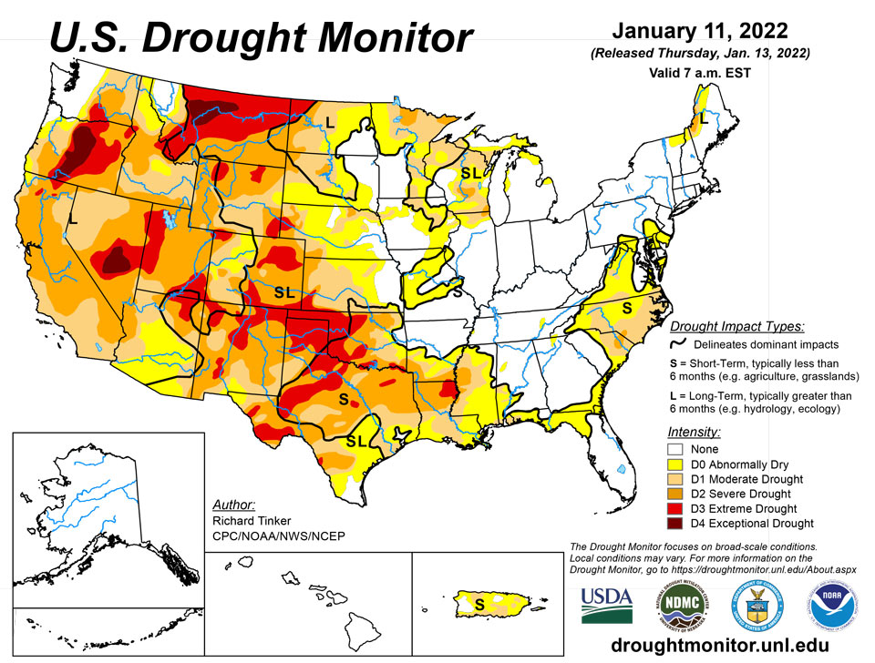
January 13, 2022 - Heavy precipitation pelted the northern half of the West Coast again this week. The largest amounts were reported in westernmost Washington and adjacent Oregon, where 6 to 10 inches of precipitation fell. Similar totals – though less widespread – were recorded across the northern half of the Cascades. Amounts decreased moving southward, with coastal areas and higher elevations from central Oregon to northwestern California receiving 2 to locally near 6 inches. Farther east, 2 to 3 inches were common across the Idaho Panhandle and the higher elevations farther south and east, including western Wyoming and north-central Colorado. Farther east, heavy precipitation also pelted the southern Ohio Valley and the lower Mississippi Valley. Generally 2 to 3 inches, with isolated higher amounts, fell on a swath south of the Ohio River, central and northeastern Arkansas, and part of easternmost Texas. Moderate precipitation – 0.5 to 2.0 inches – fell on parts of the Pacific Northwest, the northern Intermountain West, and the central and northern Rockies adjacent to areas with higher amounts. Similar totals also fell on parts of the Great Lakes Region, and in the East from the Ohio River to the Atlantic and Gulf of Mexico coasts. Light to locally moderate precipitation (0.25 to locally over 0.5 inch) dampened most of the Carolinas, Virginia, the interior Northeast, and portions of the central and northern Great Plains. Elsewhere, little if any precipitation fell, including an area from Oklahoma and Texas westward across much of Nevada and southern California. Looking at the 48-states as a whole, there was considerably more improvement than deterioration, as most areas that were dry this week didn’t seem to deteriorate much, if at all.
Northeast
Moderate precipitation (0.5 to 1.5 inches) fell along the Northeast Coast, most of Maryland, western Pennsylvania, and part of upstate New York. Other areas received a few tenths of an inch. Recent precipitation has been sufficient to remove abnormal dryness from central Maryland and portions of southern Pennsylvania. Precipitation was somewhat heavier across West Virginia (1 to locally 3 inches outside the Panhandles), and abnormal dryness was removed from the state, except for eastern portions of the Panhandle adjacent to Maryland. Some marked short-term precipitation deficits across northern New Jersey and adjacent portions of Pennsylvania and southern New York, but there are no reports of any impacts, and precipitation has increased slightly over the last 2 weeks, so no abnormal dryness was brought into the region at this time.
Southeast
While precipitation totals varied significantly across the region, and there were no large-scale changes introduced. Parts of central Alabama and adjacent locations reported moderate rains sufficient bring improvement into the region, while another week of subnormal precipitation led to D0 expansion southward along the Carolinas Coastline into part of eastern Georgia. Some small-scale changes to the D0 along the northeastern Gulf Coast were introduced based on rainfall during the past couple of weeks and developing short-term moisture deficits.
South
Moderate to heavy precipitation abetted improvement in the eastern reaches of the region while little or no precipitation fell across Oklahoma, western Arkansas, and all but easternmost Texas. In sharp contrast, only light precipitation fell on areas along the Gulf Coast, and little if any precipitation fell on northwestern Arkansas, Oklahoma, and all but easternmost Texas. Over 2 inches of precipitation ended abnormal dryness across central Arkansas and all of Tennessee, save a small residual D0 area in the western part of the state. Heavy precipitation near the southern reaches of the Louisiana/Texas border also prompted some improvement in extreme eastern Texas. Elsewhere, dryness and drought persisted or deteriorated; this region was the only one to experience considerably more deterioration than improvement. Moderate drought expanded southward through most of Louisiana, and many of the D0 to D3 areas increased in coverage across Texas expanded, thus deterioration covered a large proportion of the state.
Midwest
Moderate to heavy precipitation (0.5 to 3.0 inches) were recorded across Kentucky and the Ohio Valley while moderate amounts of 0.5 to 1.5 inches – mostly in the form of snow – fell on the northern half of Minnesota and much of the Great Lakes region. Light precipitation (at best) fell elsewhere. The heaviest precipitation fell on areas not currently in dryness or drought, so improvement was limited to northern reaches of the Great Lakes and adjacent areas. Much of the region was dry, but given the time or year lowering both natural and human water demand, only small patches of deterioration were noted in northwestern Iowa and near the Missouri/Iowa/Illinois triple point.
High Plains
Substantial precipitation (over 0.5 inch) was generally restricted to higher-elevation areas in Wyoming and Colorado. Farther east in the Plains States, only the northern and southern portions of the region recorded more than 0.2 inch. Some deterioration was introduced in southern Kansas where temperatures were the highest, but other areas from the Dakotas southward remained unchanged. Heavy precipitation has been common across the higher elevations of central and northern Colorado in the past couple of months. Some of these mountains received several inches more than normal precipitation in the last 90 days, resulting in abundant snowpack that prompted drought improvement through this region. Other areas were unchanged.
West
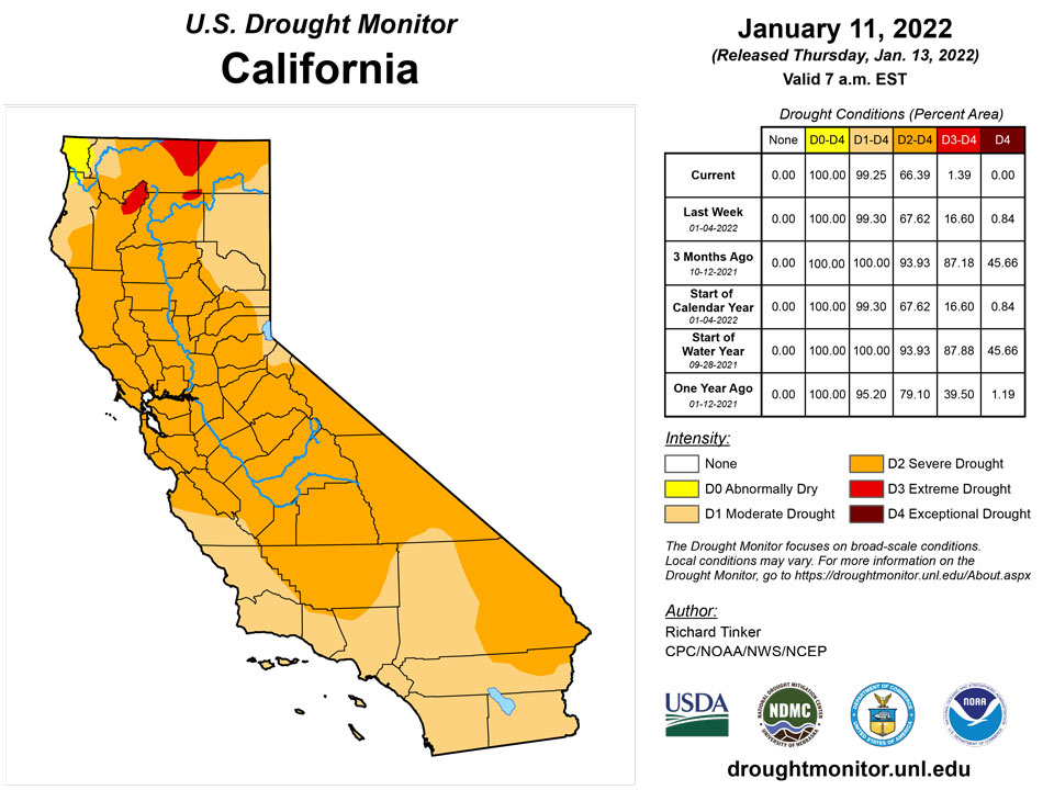
Another week of heavy precipitation affected the Pacific Northwest from the Cascades to the Pacific Coast. Precipitation was greatest in western Washington west of Puget Sound, where some areas recorded up to 10 inches of precipitation. Lesser but still above-normal amounts pelted central Washington and north-central Oregon. The valleys east of the Cascades recorded at least 0.5 inch while much of the northern Intermountain West – including most of Idaho and western Montana – reported just under an inch to nearly 3 inches in spots. Farther south, area near the coast as far south as northern California received multiple inches of precipitation, with totals closer to one inch noted in the higher elevations of northern California, including the northern Sierra Nevada. Moderate precipitation also fell on parts of northern Utah. From the Great Basin and central California southward through the southern Rockies – including the southern half of the Four Corners States – most areas received no precipitation. Based on the abundant precipitation and ample snowpack observed so far this winter, improvement was brought into several areas. Most notably, most of the large D3 area covering interior portions of northern and central California were reduced to D2. To the northeast, a significant portion of the D4 in southwestern Montana was improved to D3 for similar reasons. In addition, smaller areas across central Nevada, southern and eastern Oregon, and some central and southeastern portions of Idaho also saw significant improvement since the water year began.
Caribbean
The areas of dryness and drought across Puerto Rico were essentially unchanged from last week.
In the U.S. Virgin Islands this week, drought continued to persist or intensify. Despite a wetter week on St. John, with 0.82 inches of beneficial rainfall at Windswept Beach, drought conditions worsened to severe short- and long-term drought, as short-term rainfall deficits worsened and groundwater has not yet rebounded. St. Thomas remains in severe short- and long-term drought, driven by short- and long-term precipitation shortfalls and low groundwater. St. Croix has a similar story, with extreme short- and long-term drought remaining entrenched for the same reasons.
Pacific
Continuing improvement across Hawaii left the state without any dryness designation (D0+) for the first time since 2018.
Alaska remains free of any marked dryness or drought.
This week in Palau, rainfall amounts were 2.19 inches at Palau airport, and 2.75 inches at Koror. Drought-free conditions continue there.
Drought-free conditions continue in American Samoa this week. Rainfall totaled 0.85 inches at Toa Ridge, 1.5 inches at Pago Pago, and 2.05 inches at Siufaga Ridge.
A slightly drier week occurred on Saipan, with rainfall measurements of 0.33, 0.58, and 0.95 inches. However, wetter weather occurred last week, and drought-free conditions continue. Rota remains free of drought, after 2.04 inches of rain fell this week. Short-term abnormal dryness continues this week on Guam, where rainfall totaled 0.98 inches, marking the fifth consecutive week with less than an inch of rainfall.
Drought-free conditions continue this week on Yap, where rain totaled 2.99 inches this week. After less than a half inch of rain fell last week at Ulithi, over 3 inches fell this week, so drought-free conditions continue. Woleai only measured 0.10 inches of rain this week; however, with 2.84 inches having fallen last week, conditions there are free of drought. Recent weather has dried out on Fananu, with 0.76 inches of rain measured this week, and conditions have slipped to short-term abnormal dryness. Conditions remain in short-term abnormal dryness on Chuuk this week, where rain totaled 1.50 inches following two consecutive weeks with less than a tenth of an inch of rainfall. Over 2 inches of rain were reported locally on Lukunor, so drought-free conditions continue there. Short-term abnormal dryness developed on Nukuoro, where 0.10 inches of rain marked the third consecutive week with less than an inch of rainfall. Kapingamarangi remains in short-term moderate drought this week; after 6.41 inches of rain last week, only 0.05 inches fell this week. Weather has been relatively dry recently on Pohnpei, with 1.85 inches of rain falling this week, but conditions are not yet dry enough to be abnormally dry. Drier weather also continued on Pingelap this week, with 0.70 inches of rain, though conditions there are not yet abnormally dry. Kosrae received 1.15 inches of rain this week, marking the second consecutive week with less than 2 inches of rain. However, conditions have not yet become abnormally dry there.
Short-term abnormal dryness continues this week on Kwajalein, where 0.35 inches of rain fell this week. This marked the fourth consecutive week with less than a half inch of rain. Ailinglapalap received 0.43 inches of rain this week, which was the second consecutive week with less than a half inch of rain. However, conditions before this week were wet enough to prevent a degradation to abnormal dryness. No rain was reported on Jaluit this week, marking the second consecutive drier week (after 0.23 inches were recorded last week). Conditions have not quite degraded to abnormal dryness there, due to a very wet December that saw a monthly rain total (17.52 inches) near the 95th percentile for the month. No drought depiction is being made for Utirik this week, as the data there is missing. Conditions have degraded to severe short-term drought on Wotje, where no rain fell for the fifth week in a row. Abnormal dryness has not quite developed on Majuro, though conditions are getting close to that after only 0.91 inches of rain fell this week. On Mili, only 0.29 inches of rain were recorded, but 3 days were missing from the record for this week. Given wet conditions in December, Mili remains free of drought this week.
Looking Ahead
January 13-17, 2022 should bring more precipitation to parts of the East and Southeast. A broad area from Alabama and Georgia northward through the Carolinas, Virginia, and the Northeastern coastline should get over an inch, with scattered area of up to 2 inches in the southern Appalachians, near the Georgia/Alabama border, and in eastern North Carolina. Meanwhile, moderate precipitation of generally 0.5 to 1.0 inch is forecast across the interior Northeast and New England, and also in a swath from central North Dakota southeastward through Iowa and northern Missouri. Similar totals are expected in the coastal Northwest and the northern half of the Cascades, which will be considerably less than what the region has received for much of the winter. The rest of the 48-states will only see light precipitation at best. Most of the country west of the Appalachians should end up at least somewhat milder than normal for the period, especially from the Great Basin through the northern High Plains and Rockies, where temperatures are expected to average 8 to 16 degrees F above normal. Noticeably subnormal temperatures should be restricted to the Northeast, possibly reaching as far south as the Carolinas.
The Climate Prediction Center’s 6-10 day outlook (valid Jan 18-22, 2022) slightly favors above-normal precipitation across northern portions of the Rockies and Plains, across most of New England, and in the South from the Big Ben of Texas to the Atlantic Coast as far north as southern Virginia. In contrast, odds slightly favor below-normal precipitation in a swath from the central Ohio Valley westward into the south-central Plains. Better odds for drier than normal conditions cover much of the Four Corners States, the Great Basin, and much of the West Coast. Areas from the West Coast through the southern half of the Plains and the lower Mississippi Valley have enhanced chances for above-normal temperatures, but odds favor cooler than normal weather in the northern Plains, Great Lakes Region, Northeast, and Middle Atlantic States.
Author(s):
Richard Tinker, NOAA/NWS/NCEP/CPC
Curtis Riganti, National Drought Mitigation Center
Dryness Categories
D0 Abnormally Dry—used for areas showing dryness but not yet in drought, or for areas recovering from drought.
Drought Intensity Categories
D1 Moderate Drought
D2 Severe Drought
D3 Extreme Drought
D4 Exceptional Drought
Drought or Dryness Types
S Short-term, typically less than 6 months (agriculture, grasslands)
L Long-term, typically more than 6 months (hydrology, ecology)
SL Area contains both short- and long-term impacts
Source: National Drought Mitigation Center
