


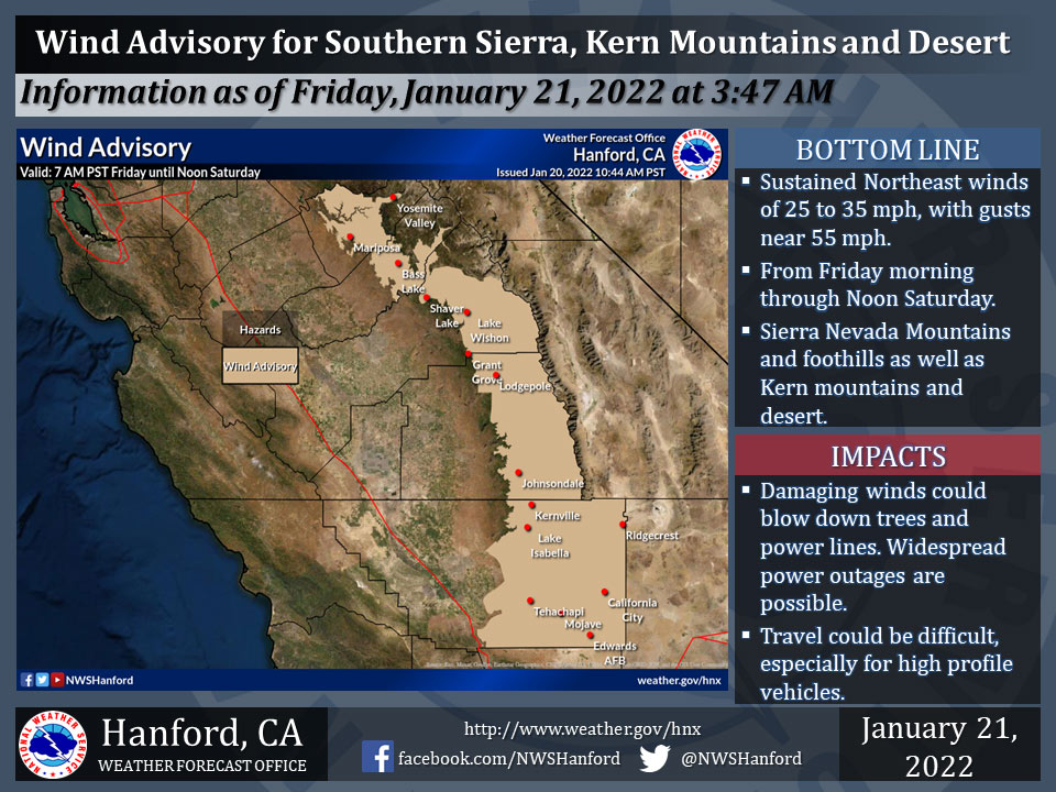
January 21, 2022 - The National Weather Service Hanford Office reports a Wind Advisory is in effect from Friday morning through Noon Saturday.
Strong wind gusts may blow down tree branches and power lines.
Scattered power outages are likely.
Travel will be hazardous, especially for high profile vehicles.
Main area impacted will be Yosemite Valley, the Madera and Mariposa foothills, the remaining Sierra Nevada (excluding the Warning area), Kern desert, and portions of the Kern mountains.
  Area Forecast Discussion
  National Weather Service Hanford CA
  121 AM PST Fri Jan 21 2022


  .SYNOPSIS...
  The potential for Tule Fog across the San Joaquin Valley is
  expected again this morning, and the possibility continues until
  next week. Gusty northeast winds will develop across the Sierra
  Nevada and the Tehachapi Mountains today and continue through
  Saturday morning. Dry weather will prevail into the foreseeable
  future.

  &&

  .DISCUSSION...
  Patchy dense fog is developing in the San Joaquin Valley,
  including here in Hanford. Dense fog will likely continue, at
  least in the south valley, until late this morning. An approaching
  upper-level trough could mitigate some fog development over
  central portions of the San Joaquin Valley, or north of Fresno
  this morning. Patchy dense fog could continue over the weekend,
  though coverage and duration may be limited with the presence of
  the trough, compared to recent days. The other concern for today
  will be strong and gusty northeast winds over the mountain areas,
  due to the approaching system. Latest satellite imagery shows the
  upper- level low and trough moving southward from Northern
  California. The low center will pass over the Great Basin today
  and arrive over the Colorado River Valley by this evening. Strong
  and gusty winds will develop in the Sierra Nevada with some breezy
  conditions into the foothills by around sunrise. Blended guidance
  continues to show gusts exceeding 50 mph at quite a few locations
  in the Sierra Nevada high country, and it is likely isolated
  gusts will reach 75 mph with plenty of upper-level support. By
  this afternoon, gusty winds will spread southward into the
  Tehachapi Mountains and Kern County desert, with isolated gusts to
  55 mph. As for the Sierra Nevada foothills, winds could gust to
  around 50 mph at isolated locations, such as towards North Fork.
  This wind event will continue into Saturday morning, and the Wind
  Advisories and High Wind Warning will remain in effect for the
  aforementioned areas. The strongest gusts are expected by this
  evening and overnight hours of Saturday morning.

  The upper-level low will continue over SW Arizona and NE Baja
  California into Saturday afternoon. Some northeast flow could
  continue over portions of Kern County until Sunday, as the upper
  low gradually moves eastward over AZ, though winds are not
  expected as strong by Saturday afternoon as gradients begin to
  relax. Dry weather will continue over the weekend into next week,
  with daytime highs near to slightly above average. High pressure
  will likely build just off the West Coast by Sunday. For now, we
  anticipate a minor warming trend will begin early next week, and
  daytime highs will return to around 5 to 8 degrees above average
  by midweek. The potential for valley fog development is expected
  to continue each night and morning and may prevent daytime
  warming at times, depending on how long low cloud cover may
  persist.

  &&


  .AVIATION...
  Widespread MVFR visibilities in haze/mist across the San Joaquin
  Valley with areas IFR/LIFR conditions developing in fog through
  19Z Friday. Strong northeast winds gusting over 50 knots
  developing across the Sierra Nevada and the Tehachapi Mountains
  after 15Z Friday. Otherwise, VFR conditions will prevail across
  the Central CA interior during the next 24 hours.

  &&

  .AIR QUALITY ISSUES...
  On Friday January 21 2022... Fireplace/Wood Stove Burning Status
  is: No Burning Unless Registered in Fresno... Kern... Kings...
  Madera and Tulare Counties.
  Further information is available at Valleyair.org
Source: NWS
