


California and National Drought Summary for February 1, 2022
Summary
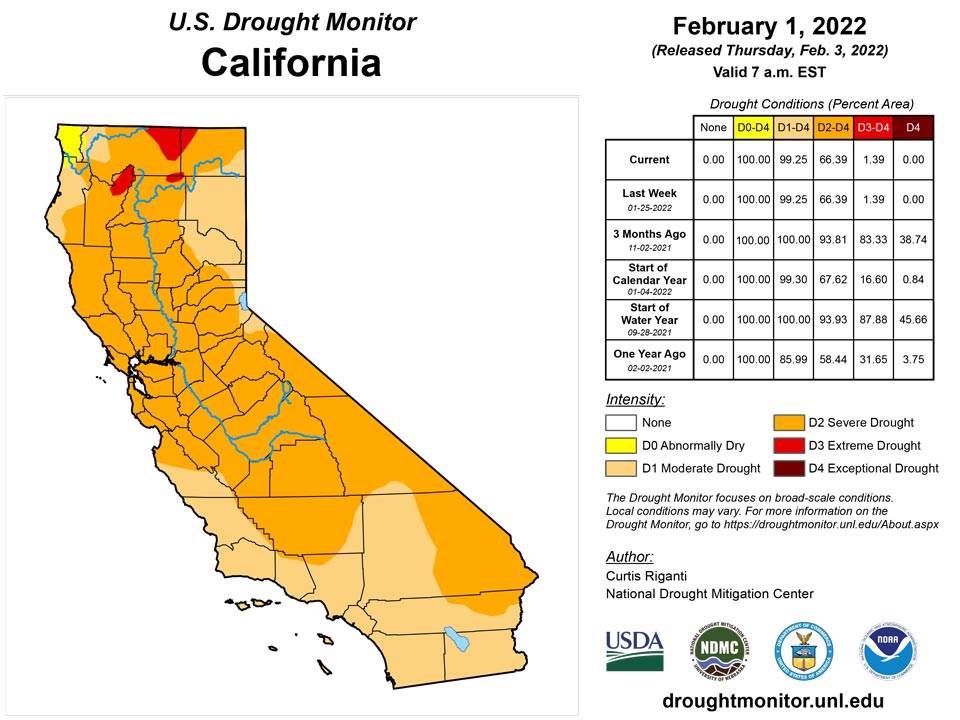
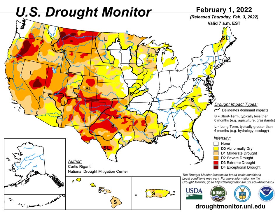
February 3, 2022 - With a few notable exceptions, the past week was mostly dry in the contiguous U.S. Heavy rain fell in southeast Texas this week, where large parts of ongoing drought or abnormal dryness saw improvement or full removal. Widespread precipitation of over a half inch fell in the Pacific Northwest, though this was primarily in areas not experiencing drought or was not enough to result in improvements to drought conditions. Heavy snow fell in a localized band across parts of western Kansas and eastern Colorado, totaling 27 inches at Mt. Sunflower, Kansas. Snow also fell in the Denver area. These snow events allowed for improvement to ongoing severe and extreme drought. A powerful Nor’easter dropped heavy snow from eastern Virginia northeast into southern and eastern New England, though most of this snow fell in areas without drought. Mostly dry weather continued in Puerto Rico, where moderate drought expanded and severe drought was introduced. After heavy snow in December helped to build up high elevation snowpack in the West, particularly in California, very dry weather took over in January across much of the region, halting improvements to drought conditions and raising concerns about lagging snowpack if the drier weather continues as forecast. Finally, it should be noted that the large-scale winter storm affecting the central and southern Great Plains, Midwest, and parts of the eastern U.S. from the afternoon of February 1 through February 4 will not be accounted for until next week’s map.
Northeast
A powerful Nor’easter developed this week and moved northeast off the Atlantic Coast, depositing heavy snowfall from eastern Virginia northeast into parts of southern and eastern New England. The highest snow totals reported in Rhode Island, New York (on Long Island), and Massachusetts each exceeded two feet. In parts of northern New England that missed out on the snow, short-term dryness continued to develop on top of long-term abnormal dryness and drought, leading to an increase in the coverage of abnormal dryness. Abnormal dryness coverage in southern New York also increased in areas that missed out on significant precipitation with the weekend Nor’easter.
Southeast
With the exception of Florida, mostly dry weather enveloped the Southeast this week. Ongoing short-term moderate drought continued in Virginia, North Carolina, South Carolina, southwest Alabama, and the western Florida Panhandle. Along the borders of Georgia, South Carolina, North Carolina, and Tennessee, short-term abnormal dryness expanded slightly, where short-term precipitation deficits mounted along with decreasing streamflow and soil moisture. No other changes were made to the Drought Monitor depiction in the Southeast this week.
South
Widespread heavy rain fell this week in southeast Texas, leading to improvements in ongoing moderate drought and abnormal dryness there. Otherwise, the week was mostly dry across the region. Extreme drought developed in parts of northern Louisiana and southern Arkansas and northeast Texas, and some ongoing extreme drought areas expanded in this region as well. There, short-term precipitation deficits worsened, and soil moisture and streamflow decreased. Severe drought expanded in south-central Texas and north of Lubbock, while extreme drought north of Lubbock shrank in coverage due to lessened precipitation deficits there. Widespread extreme drought is ongoing across much of northwest Texas and western Oklahoma, with a narrow strip of exceptional drought present in the western Oklahoma Panhandle and northeast New Mexico. Burn bans remain in effect in parts of the Southern Plains, where the winter wheat crop is also struggling.
Midwest
Mostly dry weather occurred in the Midwest region this week. Short-term moderate drought expanded into southwest Missouri this week, where short-term precipitation deficits grew. Moderate drought expanded across southern Wisconsin, where soil moisture and precipitation deficits grew. Precipitation was sufficient to improve the Northwest Angle in Minnesota from severe to moderate drought.
High Plains
This week, a narrow band of heavy snow fell in eastern Colorado and western Kansas, leading to small improvements in severe and extreme drought in these areas. Extreme drought also improved in the Denver area due to snowfall this week. Due to improved precipitation deficits, improved snowpack, and improved soil moisture conditions, moderate and severe drought were improved in southeast and west-central Wyoming. Increasing short-term precipitation deficits, along with unusually warm and windy weather, led to an expansion of severe drought in northwest South Dakota. Short-term precipitation deficits are also starting to build across southwest North Dakota. In northwest North Dakota, increased snowpack allowed for a reduction in moderate, severe, and extreme drought. Conditions continued to dry in the short-term in central and eastern Nebraska, where moderate drought increased in coverage and abnormal dryness grew slightly near and north of Lincoln.
West
Weather across the West region was mostly dry this week. A small area of precipitation along the Idaho/Montana border improved conditions enough for a small reduction in abnormal dryness there. Exceptional drought was introduced in and around Roswell, New Mexico this week, due to significant short-term precipitation deficits and warm and windy conditions that have resulted in the loss of topsoil. After a very dry January, high elevation snowpack in parts of the West has begun to drift away from the above-normal values from the start of the new year.
Caribbean
Dry weather occurred across most of Puerto Rico this week. Due to increasing precipitation deficits and a decline in streamflow, severe drought was added in northeast and southeast Puerto Rico. Moderate drought and abnormal dryness also expanded across much of the island. Moderate drought also developed this week on Vieques.
Severe to extreme drought (D2-D3) is entrenched across the U.S. Virgin Islands, with St. Thomas deteriorating to D3 this week. After tropical systems brought moderate to heavy rain to the Islands for the first half of August 2021, precipitation has been persistently and significantly below normal, especially on St. Thomas and St. Croix, which missed a couple of significant rain events observed at St. John in autumn. At King Airport on St. Thomas, the last 5.5 months brought 11.24 inches of rain – less than half of normal, and a deficit exceeding one foot. Meanwhile, Rohlsen Airport, near Christiansted on St. Croix, received 10.59 inches for the same period, which is similarly less than half of normal and a deficit approaching one foot. Longer-term moisture deficits here are larger than on St. Thomas or St. John, with 29.08 inches of rain recorded since November 2020 compared to a normal approaching 50 inches. Local reports indicate many home cisterns and water catchments are low or nearly empty. Some residents relying on these sources of water have needed to purchase water from elsewhere. Farmers have been buying hay, putting up irrigation tubes, and extensively mulching the ground to preserve whatever water is still in the ground. Poultry producers on all three islands are buying water, and several water truck delivery companies have seen demand jump markedly since mid-November, when the topmost layer of soil started to crack.
Pacific
Alaska remained free of drought or abnormal dryness this week.
Drier weather continued this week in Hawaii. The Big Island of Hawaii and Maui were downgraded to short-term moderate drought, and abnormal dryness now covers Oahu and Kauai. Short-term precipitation deficits have grown and streamflow has lessened across the state.
While the protracted drought affecting Kapingamarangi and the southern reaches of Micronesia, short-term drought persisted or intensified across the northern and western Marshall Islands. Meanwhile, abnormal dryness with a few patches of moderate drought remained unchanged over the southern Marshall Islands, central Micronesia, and the northern Marianas.
Koror in Palau reported 11.32 inches of rain in January 2022 – almost exactly normal. Three of the last seven months brought only 55 to 75 percent of normal rain, but three others featured 145 to 229 percent of normal. And given the wet climatology, no impactful precipitation deficits are affecting the country.
Saipan in the Marianas reported only 3.12 inches of rain in January. Although November and December brought above-normal precipitation, the 7.3 and 5.9 inches were below the amount that can potentially stress water needs. Earlier – during the wet season – enough rain fell to meet immediate needs, but August – October totals were several inches below normal, so abnormal dryness (D0) remained in place. Farther south, rainfall in Rota and Guam has been unremarkable, and no dryness impacts have been reported.
In Micronesia, the protracted drought entrenched in Kapingamarangi and other southern reaches of the Islands continued to loosen its grip. The 7.92 inches recorded in January 2022 pushed the 2-month total to 22.5 inches – somewhat above the normal of 19 inches. The prior 4 months brought only 13.4 inches of rain, about 36 percent of normal. The last two months have not eliminated the longer-term rainfall deficits nor their impacts, but conditions have improved considerably. Farther north, conditions are essentially unchanged from last week. Moderate drought (D1) remains on Fananu, and abnormal dryness (D0) persists on Woleai, Chuuk Lagoon, and Nukuoro – all for short-term deficits and impacts. Ulithi, Lukunor, Pohnpei, Pingelap, and Kosrae remained free of impacts from deficient rainfall. Fananu recorded only 1.22 inches of rain for January 2022, considerably less than the 5.72 inches for January 2021, and a sharp drop from December’s total of 11.44 inches. The short-term but steep rainfall deficit put Fananu into moderate drought last week, where it remains. Dryness also developed quickly at Chuuk Lagoon, where the January total of 3.93 inches was only 38 percent of normal, and not sufficient for water supply to keep pace with demand. Similarly, 2.88 inches of rain fell on Woleai in January – only 38 percent of normal and not enough for water supply to keep pace with demand that month. The short—term abnormal dryness at Nukuoro evolved differently. There, January totals were several inches higher, but somewhat longer-term deficits remained. The October-January total of 36.5 inches was about 10 inches less than normal, and water demand out-paced water supplies for 2 of the last 4 months
In the Republic of the Marshall Islands, marked drought conditions persisted or intensified over northern and western parts of the Republic while less-impactful dryness has been noted in southeastern areas. Only southwestern areas (Jaluit and surrounds) remain free of impactful dryness. No rainfall was reported on Wotje in January 2022, and just 2.55 inches fell during December. The 2-month total was only 35 percent of normal, and not enough for water supply to keep pace with demand. This was enough to keep extreme drought (D3) in place. Half of the past 14 months brought 75 percent or less of normal precipitation, and only one of those months (November 2021) brought more than the 8 inches that ensures water supply keeps pace with demand. Rainfall totaled 53.21 inches for December 2020 – January 2022, which is more than one foot less than normal. Data for nearby Utirik is lacking, but local reports indicate conditions similar to Wotje and consistent with a D3 designation. To the west, drought is not as extreme, but is intensifying. Dryness intensified at both Kwajalein and Ailinglapalap, which are now designated D2 and D1, respectively. Only 1.25 inches of rain fell on Kwajalein in January 2022, bringing the 2-month total to only 4.99 inches, which is 41 percent of normal and not enough for water supplies to keep pace with demand. The wetter time of year (September – November) had near normal rainfall, but the prior 3 summer months had significantly less than normal rain. So despite the wet autumn months, rainfall since June 2021 totaled 57.82 inches – more than 16 inches less than normal. Ailinglapalap recorded 3.2 inches of rain in January 2022 – about half of normal and significantly less than what is needed for supply to keep pace with demand. The prior 4 months were sufficiently wet there, but May – August each brought less rainfall than needed. Meanwhile, marginal abnormal dryness (D0) remained in place in Mili and Majuro while Jaluit remained free of impactful dryness. Many catchments are very low or empty. Some wells are salty but well water levels are still decent. Catchment water is being used for drinking only on many islands with some using coconuts for hydration. Plants are yellow to brown with some plants absent of leaves. Some fruits are dropping prematurely. Some islands have reverse osmosis units but many are inoperable. Many islands have 2-4 weeks of water left if no rain falls.
In American Samoa, Pago Pago and Siufaga Ridge received 13 to 16 inches of rain, keeping impactful dryness at bay. Rainfall has increased since a dry September – October began to raise concerns.
Looking Ahead
At the time of writing (the afternoon of Wednesday, February 2), a large-scale winter storm was causing snow and ice accumulation across much of the southern Great Plains and lower Midwest. Precipitation, both wintry and plain rain, was forecast by the National Weather Service Weather Prediction Center to continue eastward and northeastward through the middle of the weekend, with some heavier precipitation amounts possible, particularly from Alabama northeast to southern Ohio. On Sunday and Monday (February 6-7), mostly dry weather was in the forecast across the contiguous U.S., though some precipitation was expected along the southeastern coast.
For the period from February 8-12, the National Weather Service Climate Prediction Center forecast strongly favored drier than normal weather across much of the West region. Drier weather was also favored from the central and southern Great Plains east to the Atlantic Coast. Wetter than normal weather was favored in south Texas, the northern Great Plains, and northwest Great Lakes. Above-normal precipitation was also favored for this period in most of Alaska. Warmer than normal temperatures were strongly favored along the Pacific Coast, and in the central and northern Great Plains and Upper Midwest. From New Mexico eastward, colder than normal temperatures were favored across the far southern U.S. Colder than normal temperatures were favored in western Alaska, while southeastern Alaska was more likely to see above normal temperatures.
Author(s):
Curtis Riganti, National Drought Mitigation Center
Richard Tinker, NOAA/NWS/NCEP/CPC
Dryness Categories
D0 Abnormally Dry—used for areas showing dryness but not yet in drought, or for areas recovering from drought.
Drought Intensity Categories
D1 Moderate Drought
D2 Severe Drought
D3 Extreme Drought
D4 Exceptional Drought
Drought or Dryness Types
S Short-term, typically less than 6 months (agriculture, grasslands)
L Long-term, typically more than 6 months (hydrology, ecology)
SL Area contains both short- and long-term impacts
Source: National Drought Mitigation Center
