


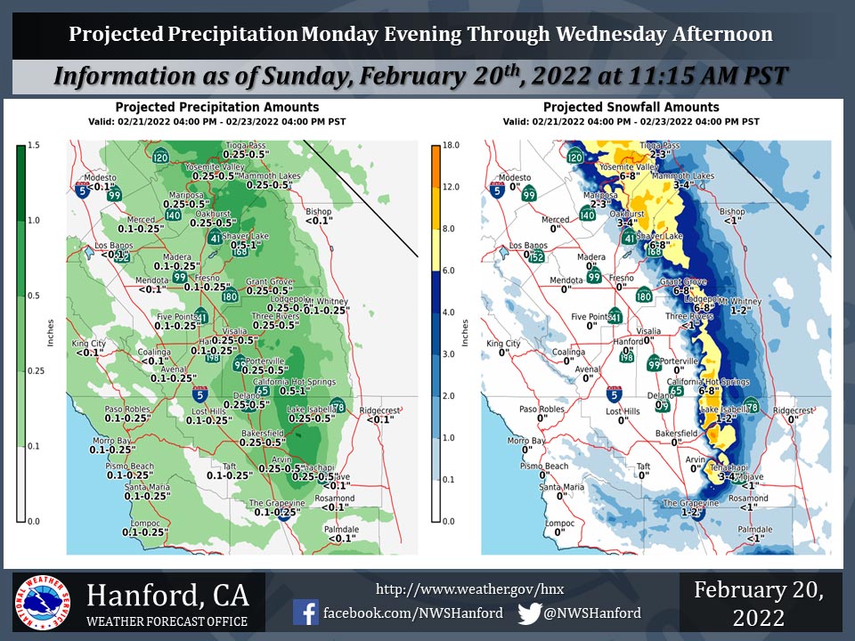
Projected Snowfall Amounts for Mariposa 2.00" - 3.00"
Projected Snowfall Amounts for Oakhurst 3.00" - 4.00"
Projected Snowfall Amounts for Yosemite Valley 6.00" - 8.00"
February 20, 2022 - The National Weather Service Hanford Office reports a storm system will impact Central California Monday evening through Wednesday afternoon.
The snow level will start at around 2,500 feet Monday evening, before falling to about 1,000 feet by Wednesday morning.
The majority of this precipitation will fall Tuesday afternoon and Tuesday evening.
  Area Forecast Discussion
  National Weather Service Hanford CA
  1216 PM PST Sun Feb 20 2022


  .SYNOPSIS...Mild temperatures will persist today, and then
  colder temperatures will return on Monday. A low pressure system
  will impact Central California Tuesday afternoon into Wednesday
  morning and result in a chance of rain and mountain snow, as well
  as unseasonably cool temperatures. A cold airmass will continue
  over the area behind this system, and sub-freezing minimum
  temperatures are likely across much of the San Joaquin Valley by
  later in the week.

  &&

  .DISCUSSION...
  A deep Pacific Northwest trough will drop down into the southwest
  this week will allow a cold polar airmass to intrude into the
  northern Plains states and even into the Great Basin. The
  harbinger of whats to come will be cooler temperatures and increased
  winds. Later this evening winds will get breezy and by tomorrow
  morning will strengthen due to a tightening pressure gradients
  ahead of the main system which is still just entering the Pacific
  Northwest. A wind advisory has been issued for the Kern County
  desert areas from 10 AM Monday through 10 PM Tuesday.
  Northwesterly to westerly winds will gust to around 50 mph in the
  most wind prone areas such as the foot of the mountain passes on
  the desert side.

  By late Monday into Tuesday morning the deepening trough will
  pivot southward into the region further ushering in colder
  temperatures and increased chances of precipitation. Snow levels
  will start out around 4000 feet Monday night and by the onset of
  precipitation around 00z Tuesday in the higher elevations in the
  northern parts of the CWA the snow levels will drop to around 2500
  to 3000 feet. The system will continue to move southward and
  areas of the Sierra south of Sequoia National Park will begin to
  see precipitation begin around 06z Tuesday. The Kern County
  mountains will also be seeing an increase in precipitation chances
  shortly after that. A couple of Winter Weather Advisories have
  been issued to address these weather issues. The first Winter
  Weather Advisory for the Sierra north of Sequoia National Park
  will begin at 4 PM Monday and the second Winter Weather Advisory
  from the Sequoia National Park southward into the Kern County
  mountains, including the Grapevine pass area, will begin at 10 PM
  Monday. Both advisories will run through 4 PM Wednesday. This
  will address the impacts from the snowfall and the gusty winds
  with this system. Hikers and Campers really need to be prepared
  for this drastic change in the weather conditions. We have been
  really warm and will be returning to below normal temperature-wise
  in a very short time period. Also will be throwing in the winter
  precipitation for areas above 2000 feet. So it would definitely be
  best to return to lower elevations if you are unprepared before
  this storm gets here.

  By the time the precipitation ends on Wednesday afternoon snow
  levels will be around 1500 feet. So light low elevation snow
  showers will not be out of the question. Roads will be slick and
  care will be needed when traveling during this storm. Be sure to
  carry chains/cables inside your vehicle. Once the precipitation
  ends, we will still be dealing with the cold airmass in place
  behind the trough, so get those winter coats back out. Wednesday
  morning overnight low temperatures in the San Joaquin Valley will
  drop to the lower 30s and into the upper 20s in the Kern County
  desert areas. Any lingering clouds as the trough exits the area
  could keep temperatures just a tad warmer. But by Thursday morning
  with skies mostly cleared temperatures will drop to the upper 20s
  in the San Joaquin Valley and the lower 20s in the Kern desert
  areas. There is a 75 percent chance of a low temperature below 32
  for Merced and 66 percent chance for Fresno on Thursday morning.
  For Edwards area in Kern County desert there is a 100 percent
  chance of this occuring on Thursday morning. Friday will be
  slightly warmer but still a good chance we will see freezing
  temperatures once again. This will be monitored over the next
  couple of shifts. Farmers will need to start preparing for this
  incoming cold air mass. Big changes coming, be prepared.

  &&

  .AVIATION...VFR conditions will prevail across the Central
  CA interior through at least the next 24 hours.

  &&

  .AIR QUALITY ISSUES...
  On Sunday February 20 2022... Unhealthy for sensitive groups in
  Fresno County.  Fireplace/Wood Stove Burning Status is: No Burning
  Unless Registered in Kern... Kings... Madera... Merced and Tulare
  Counties. No Burning For All in Fresno County.
  Further information is available at Valleyair.org
Source: NWS
