


California and National Drought Summary for March 1, 2022
Summary
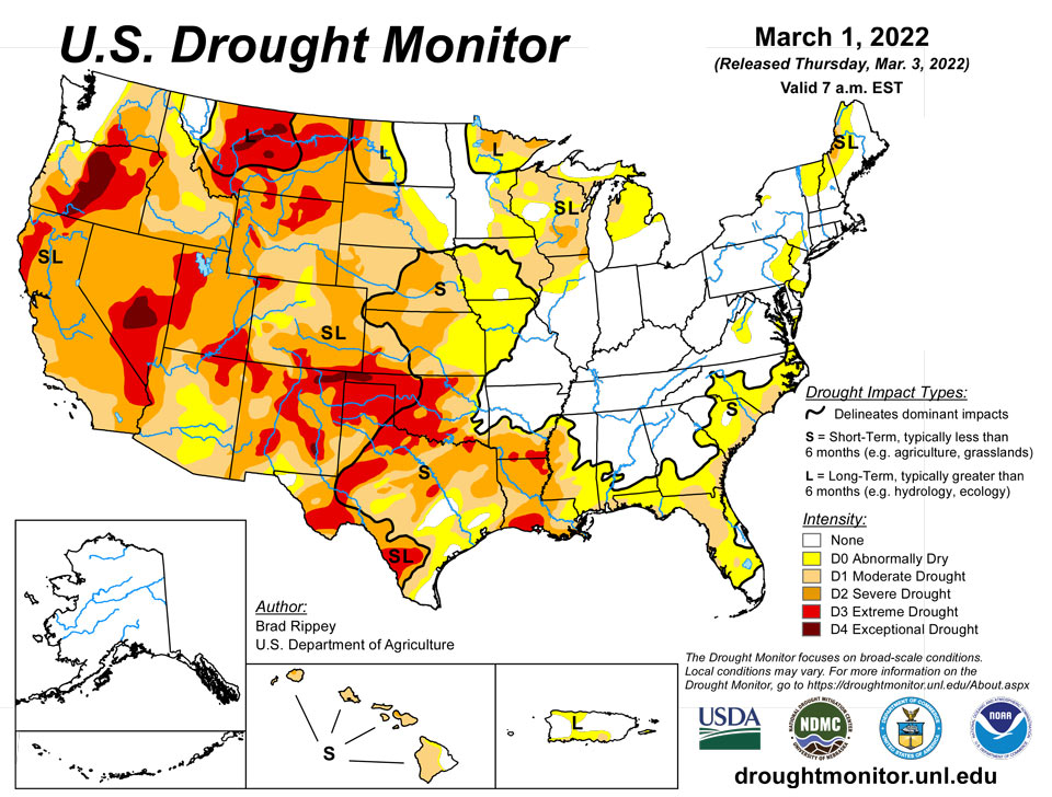
March 3, 2022 - The drought-monitoring period, which began on the morning of February 22 and ended early March 1, featured some wild temperature swings, along with a band of heavy precipitation stretching from the mid-South into the Northeast. In fact, this represented the second consecutive monitoring period with significant precipitation along nearly the same axis, while many other parts of the country received little or no moisture. As a result, gradual expansion of dryness and drought was the rule across much of the western half of the nation, extending into parts of the upper Midwest, as well as the southern Atlantic States and the Gulf Coast region. In contrast, heavy precipitation kept drought at bay from the Ozark Plateau into the Ohio and Tennessee Valleys and the lower Great Lakes region. Significant precipitation also fell in drought-free areas of the Pacific Northwest, leading to another round of flooding in parts of western Washington.
Northeast
Variable precipitation totals were observed in the Northeast. However, areas in northern New England experiencing moderate to severe drought (D1 to D2) did not receive enough moisture to have a meaningful impact. Farther south, scattered showers in the middle Atlantic States resulted in negligible change in the depiction of patchy dryness (D0).
Southeast
A few areas, including southwestern Virginia and western and central North Carolina, received heavy rain, leading to a reduction in the coverage of abnormal dryness (D0). However, much of the region—especially east of the Appalachians and across the Deep South—remained mostly dry. As a result, dryness (D0) and moderate drought (D1) broadly expanded from Florida to southeastern Virginia. In recent days, several fires have flared in the southern Atlantic States, including the 1,500-acre WF5 Rum Creek Fire east of Arcadia, Florida. Winter (December-February) precipitation totals in Florida totaled just 2.67 inches (34% of normal) in Tampa and 2.07 inches (29%) in Sarasota-Bradenton). According to the U.S. Department of Agriculture, Florida’s topsoil moisture was rated 44% very short to short near the end of February. At the same time, Florida’s pastures were rated 57% very poor to poor, as grasses that were burned back by late-January freezes have been slow to recover due to lack of rainfall. In recent weeks, Florida and neighboring areas in the lower Southeast have also experienced very warm weather. For example, Fort Myers, Florida, logged highs of 85°F or higher each day from February 20-27, including daily-record maxima of 89°F on the 23rd, 24th, and 26th.
South
For the second week in a row, a sharp contrast existed between heavy precipitation in the mid-South and mostly dry weather closer to the Gulf Coast and across the southern Great Plains. That pattern, consistent with La Niña, helped to sharpen the drought gradient across Arkansas and Mississippi. Meanwhile, extreme drought (D3) was expanded in several areas, including southwestern Louisiana. Winter (December-February) rainfall totaled just 5.18 inches (39% of normal) in New Iberia, Louisiana, and 3.94 inches (29%) in Beaumont-Port Arthur, Texas. On February 27, statewide topsoil moisture in Texas and Oklahoma was rated at least three-quarters very short to short, according to the U.S. Department of Agriculture. On that date, winter wheat was rated 75% very poor to poor in Texas, along with 65% in Oklahoma. Texas also reported 69% of its rangeland, pastures, and oats were rated very poor to poor. Burn bans were in effect for dozens of counties across Texas, as well as western and central Oklahoma.
Midwest
A late-February cold spell abruptly yielded to warm weather at month’s end into early March. Roller-coaster temperatures in Iowa included Sioux City’s swing from a daily-record high of 66°F on February 20 to a daily-record low of -9°F on February 25. In fact, Sioux City reported temperatures of 0°F or below each day from February 22-25. However, Sioux City rebounded to 69 and 72°F, respectively, on February 28 and March 1. Meanwhile, only light precipitation fell across the heart of the Midwest, with significant totals confined to drought-free areas in the Ohio Valley and environs. A strong signal of short-term dryness and moderate drought (D0 and D1) further amplified across Iowa and northwestern Missouri. Farther north, a small amount of D0 and D1 trimming occurred in the upper Great Lakes region, following a snowy February and winter. Marquette, Michigan—not currently in an area experiencing dryness—received December-February snowfall totaling 152.5 inches (128% of normal) and reported a 42-inch snow depth on February 23.
High Plains
For much of the winter of 2021-22, the High Plains were beset by sharp temperature fluctuations and only periodic precipitation, leaving drought largely intact through the cold season. Sub-zero, daily-record lows on February 23 plunged to -8°F in Burlington, Colorado, and -2°F in Russell, Kansas. Several weather stations, including Goodland, Kansas, and Grand Island, Nebraska, reported four consecutive sub-zero minima from February 22-25. By March 1, temperatures rebounded to 73°F in Goodland and 75°F in Grand Island. Farther north, however, drought has been eradicated from the eastern Dakotas, with spring flooding becoming more likely in the Red River Valley of the North. In eastern North Dakota, persistently cold weather has helped to maintain an impressive snow cover. Across the remainder of the region however, short-term precipitation deficits have become superimposed over long-term shortfalls. By February 27, the U.S. Department of Agriculture reported topsoil moisture in Kansas was 80% very short to short, while 38% of the state’s winter wheat was rated in very poor to poor condition. In part due to short-term precipitation deficits, severe drought (D2) was broadly expanded across Kansas and Nebraska, with corresponding increases in other drought categories.
West
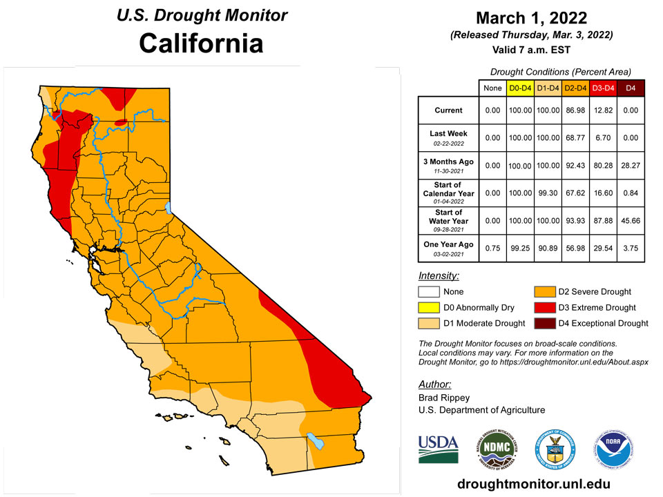
Most of the region experienced an extremely disappointing January-February period, with some locations, including downtown San Francisco, California, reporting record-low precipitation totals for those 2 months. San Francisco’s 2-month total of 0.65 inch (7% of normal) eclipsed the record of 0.72 inch established in January-February 1852. Downtown San Francisco also received no rain—not even a trace—from January 8 to February 20, a span of 44 days, followed by a meager 0.04 inch on the 21st. San Francisco’s longest winter dry spell remains 46 days, from December 1, 1876, to January 15, 1877—a streak that began in late autumn (on November 17) and extended to 60 days. The longest modern winter dry spell in San Francisco’s history stretched 43 days, from December 25, 2014 – February 5, 2015. Other California locations setting records for January-February dryness included San Jose (0.01 inch), Fresno (0.04 inch), Sacramento (0.05 inch), and Eureka (2.39 inches). According to the California Department of Water Resources, the average water equivalency of the Sierra Nevada snowpack stood near 15 inches at the end of February (less than two-thirds of average for the date)—effectively no change from the beginning of the year. Similar scenarios played out in many other areas of the western U.S., with promising early-season snowpack “flatlining” during January and February. By the end of February, basin-average snowpack water equivalency values were close to normal only in selected areas, including the northern Cascades, portions of the northern and central Rockies, and the Wasatch Range. Significantly below-average snowpack (less than 70% of average) was common across the Sierra Nevada and the northern Great Basin, extending into parts of southern and eastern Oregon. Low snowpack numbers were also noted in parts of eastern Wyoming and large sections of the Southwest.
Caribbean
In Puerto Rico, impacts related to long-term rainfall deficits were greatest on the southern slopes, where abnormally dry conditions (D0) and moderate drought (D1) have contributed to poor pasture conditions, low streamflow, and below-average reservoir storage. Dryness extended across portions of the interior to the northwestern coast of Puerto Rico.
Long-term drought continued across the US Virgin Islands this week since rainfall totals across the region were less than half an inch this week. Groundwater hasn't improved and continues to steadily decline across all three locations. This week, Cyril E. King Airport, St. Thomas had only 0.30 inch of rain, which resulted in a month total of 3.29 inches or 173.2% of normal. The year-to-date rainfall total at the airport is close to normal. SPI values at the 1 and 3 months periods were indicative of no drought; however, long-term drought was evident at the 6 (-1.57), 9 (-1.04), and 12 (-0.82) months. Long-term extreme drought persisted for St. Thomas.
Similarly, the Henry Rohlsen airport had 0.48 inch of rain for the week, while the different CoCoRaHs locations had rainfall between 0.01 to 0.24 inch. The February 2022 rainfall total at the airport was 4.86 inches or 360.0% of normal and year-to-date was 215.2%. SPI was indicative of moderate drought at the 6 (-0.8), 9 (-1.08), and 12 (-1.21) months. For this week, severe drought was unchanged for St. Croix.
St. John continued to be in moderate drought since rainfall totals ranged between 0.03 to 0.25 inch of rain this week. The February 2022 rainfall total was 4.09 inches or 189.4% of normal for the month -- the fourth wettest February since data records began in 1984. The year-to-date was slightly above normal at 106.6% of normal. SPI values were indicative of drought free conditions at the 1 and 3 months, while the 6 (-0.68), 9 (-0.55), and 12 (-0.63) months were indicative of abnormally dry conditions.
Pacific
There were no changes in Alaska, which remained free of dryness and drought through a winter that has featured wild temperature swings and ample to abundant precipitation.
In Hawaii, a 2-month dry spell has resulted in the return of widespread moderate to severe drought (D1 to D2), following a 3-week period in January where there was neither dryness nor drought. Through February 28, year-to-date rainfall at the state’s major airport observation sites ranged from 0.19 inch (4% of normal) in Kahului, Maui, to 7.83 inches (43%) in Hilo, on the Big Island. By the end of February, small pockets of D2 were noted on Maui and Kauai, while only windward sections of the Big Island were free of dryness and drought. Impacts from Hawaii’s short-term drought included low streamflow and poor vegetation health.
Drought is not a concern across Palau since its weekly rainfall total was over 3 inches and had over 10 inches for the month of February.
Abnormally dry conditions persisted across the Marianas since rainfall totals were less than an inch and rainfall totals for February across the region were less than half the monthly threshold of 4 inches to meet most water needs.
In the Federated States of Micronesia, Pohnpei, Kosrae, Kapingamarangi, Nukuoro, and Pingelap had a wet week, with weekly rainfall totals over 3 inches. Since this marked Nukuoro's second consecutive week with rainfall totals over 3 inches and its February total was over 8 inches, Nukuoro's drought classification was changed from abnormally dry to drought free conditions. Pohnpei, Kosrae, Kapingamarangi, and Pingelap all continued to be drought free.
Severe drought persisted across Fananu since only 0.24 inch of rain fell this week. According to the latest drought statement (February 25, 2022), vegetation is dying and water tanks on Fananu are empty and the community tank is either empty or extremely low. Little rain fell across Chuuk Lagoon (0.10 inch) and Woleai (0.36 inch), securing another week of moderate drought. Following a very wet week, Ulithi only had 0.34 inch of rain this week. However, drought is not a concern for Ulithi at the moment.
Most locations across the Marshall Islands had a dry week with rainfall totals less than 1 inch across most locations. Mili was the only location to have over 2 inches of rain, while Ailinglaplap had over 1 inch of rain. Wotje had only 0.05 inch of rain, so extreme drought continued. Kwajalein and Ailinglaplap continued to be in moderate drought, while abnormally dry conditions persisted across Jaluit, Majuro, and Mili.
Rainfall total in Pago Pago was over 2 inches of rain this week, the highest out of the three locations. Toa Ridge had over 1 inch, while Siufaga Ridge had 0.93 inch of rain. Drought free conditions continued since the February 2022 totals were over three times the monthly threshold to meet most water needs.
Looking Ahead
Showery weather, initially confined to the nation’s northern tier, will gradually engulf the much of the West before spreading eastward. A return to chilly weather will accompany and trail the increasingly unsettled weather. However, storminess will bypass much of the nation’s southern tier, with the Southeast and southern sections of the Rockies and Plains remaining dry during the next 5 days. Farther north, 5-day precipitation could total an inch or more from the upper Midwest into the Great Lakes region. Precipitation will also stretch from California to the central Rockies, although amounts are not expected to be great enough to provide substantial drought relief. Still, some areas of the West could experience their heaviest precipitation since December. The NWS 6- to 10-day outlook for March 8 – 12 calls for the likelihood of below-normal temperatures from the Pacific Coast to the Mississippi Valley and the upper Great Lakes region, while warmer-than-normal weather will prevail along and east of a line from southeastern Louisiana to Lake Ontario. Meanwhile, near- or above-normal precipitation across most of the country should contrast with drier-than-normal conditions from California to the southern High Plains.
Author(s):
Brad Rippey, U.S. Department of Agriculture
Ahira Sanchez-Lugo, NOAA/NCEI
Dryness Categories
D0 Abnormally Dry—used for areas showing dryness but not yet in drought, or for areas recovering from drought.
Drought Intensity Categories
D1 Moderate Drought
D2 Severe Drought
D3 Extreme Drought
D4 Exceptional Drought
Drought or Dryness Types
S Short-term, typically less than 6 months (agriculture, grasslands)
L Long-term, typically more than 6 months (hydrology, ecology)
SL Area contains both short- and long-term impacts
Source: National Drought Mitigation Center
