


California and National Drought Summary for March 8, 2022
Summary
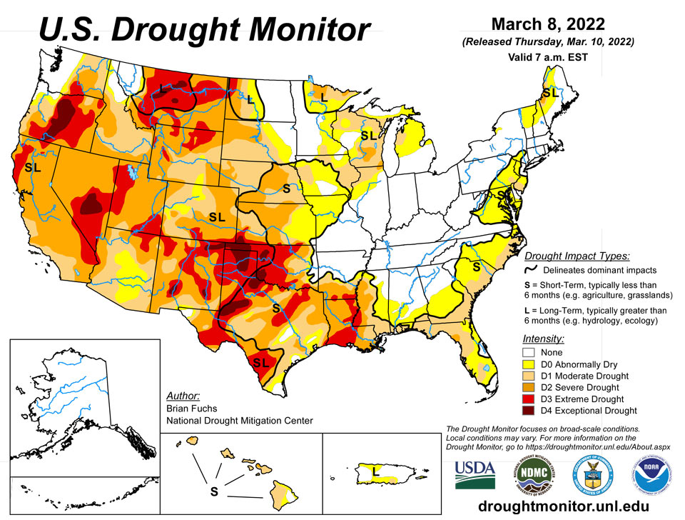
March 10, 2022 - Several storm systems from the northern Rocky Mountains to the Midwest brought with them rain, snow, and even some severe weather this past week. Temperatures for the week were cooler than normal over the northern Plains and into the West. The coldest readings were in the northern Plains and upper Midwest, with departures of up to 9 degrees below normal. Temperatures were warmer than normal over much of the eastern U.S., with the greatest departures (12-15 degrees above normal) over Tennessee and Kentucky. Areas of the Midwest, central Plains and into the West did see above-normal precipitation this week with areas of Kentucky, Indiana, and Ohio receiving over 2 inches of precipitation during the period. The southern Plains and South continue to dry out. As spring approaches and dormancy is broken, impacts are already showing in these areas and drought intensification is widespread with quickly expanding extreme and exceptional drought areas.
Northeast
Temperatures were mixed in the region, with cooler than normal temperatures in the northern reaches and warmer than normal conditions in the south. Departures were 1-3 degrees above normal in the north and 3-6 degrees above normal in the south. Coastal regions were dry for the week, but areas of Pennsylvania, New York and Maine did record over 150% of normal precipitation this week. As dryness along the coastal areas continues, abnormally dry conditions were expanded over New Jersey, eastern Pennsylvania, northern Virginia and into Maryland. Moderate drought was introduced into southern New Jersey and southeast Pennsylvania in response to recent dryness.
Southeast
Dry and warm conditions dominated the region this week. Precipitation was minimal in the region, and temperatures were 9-12 degrees above normal in the northern portions of the region and 3-6 degrees above normal in the southern portion. The driest areas remain along the coasts and Florida. Abnormally dry and moderate drought conditions were expanded in North Carolina, South Carolina, Georgia, Florida and Alabama. Severe drought was introduced in northwest Florida this week with some dry signals out to 6 months or more. Fire is one of the early impacts of the dryness, with a fire near Panama City, Florida burning over 33,000 acres so far. This area is littered with debris and damage from category 5 Hurricane Michael (which struck in October 2018) providing a great deal of fuel for this fire.
South
Temperatures were warmer than normal over most of the region, with departures of 9-12 degrees above normal over Tennessee. Areas of northern Oklahoma and Arkansas experienced the only precipitation events in the region with above-normal amounts as most all of the region was quite dry. Degradation continued with drought status over the region. As dormancy breaks and green-up begins, water demand has increased along with warmer temperatures. Exceptional drought was expanded to cover more of the Oklahoma and Texas panhandles. Severe drought was expanded over western Oklahoma along with a new pocket of exceptional drought. A full category worsening of drought conditions took place over west Texas and much of central and east Texas as severe and extreme drought expanded. Mississippi and Louisiana also had widespread degradation with extreme drought expanded over most of southern Louisiana and along the Mississippi River into Mississippi. Moderate and severe drought were also expanded over much of central Mississippi and into southeast Louisiana. The overall pattern from the southern Plains into the South has been dry and warm conditions that will only lead to worsening conditions as spring arrives. The 4-month period from November to February was the 2nd driest such period for Louisiana since 1895 with less than 10 inches of observed precipitation statewide. With some good rains in Louisiana after the data cutoff for consideration this week, there may be some opportunities for improvements next week where the greatest rains occur.
Midwest
Temperatures in the region were warmer than normal in the south, with departures of 9-12 degrees above normal, and cooler than normal in the north, with departures of 3-6 degrees below normal. Widespread precipitation over the region was recorded with many areas over 200% of normal for the week. With widespread precipitation, it was possible to show some improvements to drought conditions this week. Abnormally dry conditions were improved in south central and northeast Iowa, southwest Missouri, central Wisconsin and central Minnesota. Moderate drought was also eased in Minnesota and Wisconsin, but both states have some concerns with long-term drought.
High Plains
Precipitation was mixed in the region as portions of Wyoming, South Dakota, Nebraska, and Kansas recorded rain and snow during the week, with the winter season being quite dry overall. Temperatures were cooler than normal over the Dakotas and into western Nebraska and Wyoming with temperatures 2-4 degrees below normal. Eastern Nebraska and most of Kansas were warmer than normal with departures of 5-7 degrees above normal. Most of the region did not have any changes this week due to the lingering dryness. Kansas did have some drought intensification with severe drought expanded over the north central part of the state and along the Oklahoma border. With long-term dryness over southwest Kansas, exceptional drought was expanded out of the southern Plains and into southwest Kansas. Extreme southeast Kansas did record enough precipitation for improvement to abnormally dry and moderate drought conditions.
West
Cooler than normal temperatures were common over the region with departures of 2-4 degrees below normal over much of the West. Some precipitation in the Rocky Mountains, central Utah and Nevada as well as the Pacific Northwest did help with seasonal snow values, reversing a dry trend that most areas have had. In California, there are many who fear that the snowpack has peaked for this season at 61% of normal, which will lead to further drought issues later on. Improvements were made to moderate drought and abnormally dry conditions in northern Idaho and western Montana. Northern Oregon had improvements to severe and extreme drought as well as to abnormally dry conditions. Extreme drought was expanded over portions of southern Oregon. Extreme drought was improved over northwest Colorado as both short- and long-term conditions were improving. A small area of moderate drought was improved over eastern Wyoming while moderate and severe drought were expanded over portions of southern Idaho. The dryness in the southern Plains is also impacting portions of southern and eastern New Mexico, where drought intensified this week. A new pocket of exceptional drought was added in southwest New Mexico while moderate and severe drought expanded in southern New Mexico and extreme drought expanded over eastern New Mexico.
Caribbean
No changes in Puerto Rico this week.
The U.S. Virgin Islands received good rainfall this week, but remained status quo. St. Thomas remained at D3-L, St. Croix was at D2-L, and St. John at D1-L. Conditions were near normal or slightly wet at short time scales, but were still dry at longer time scales. Rain at most locations ranged from 0.5 to 1.5 inches for the week. Wells remained very low.
Pacific
Northern areas of the Big Island in Hawaii had some expansion of abnormally dry conditions this week while southeast portions of moderate drought improved due to recent rains. No changes in Alaska this week.
The Republic of Palau received ample rain and remains free of dryness. Two inches of rain weekly is enough to meet minimum water needs for these and most other Pacific islands.
The Mariana Islands all remained at D0-S. Rainfall was low in Guam with 0.16 inches for the week, but Rota and Saipan received more than an inch at most locations, which is enough to meet minimum water needs.
The Federal States of Micronesia were mixed with three locations in drought. Chuuk remained at D1-S for another week, but received 2.46 inches of rain. Fananu was at D2-S and has not had decent rain in roughly two months. Woleai was improved from D1-S to D0-S. Most other locations reported plenty of rain this week or the previous week.
The Marshall Islands were all dry or in drought, but increased rainfall allowed Jaluit and Mili to be improved from D0-S to normal conditions this week. Ailinglaplap was also improved from D1-S to D0-S. Other locations remained at the same drought status as the previous week. Wotje, for instance, remained at D3-SL and received just 0.05 in the past 12 weeks.
American Samoa remained free of dryness. Pago Pago International Airport’s hottest day in more than 6 years occurred on March 5 with a high temperature of 93 F. The normal high is 88 F.
Looking Ahead
Over the next 5-7 days, it is anticipated that cooler than normal temperatures will dominate the country, with departures of 9-12 degrees below normal over the Rocky Mountains and 3-6 degrees below normal over the Southeast. It is anticipated that the greatest precipitation will take place over the East coast, with local maximum amounts over southern Georgia and north Florida. Most areas are expected to record precipitation, with the northern Plains and California anticipated to be the driest.
The 6-10 day outlooks show that the likelihood of above-normal temperatures is greatest over the eastern half of the U.S., with the best chances over the Mid-Atlantic into the Northeast. Above-normal chances of below-normal temperatures are expected over Alaska. The best chances of above-normal precipitation are over the Pacific Northwest, Rocky Mountains and eastern U.S. Above-normal chances of below-normal precipitation are anticipated in the Southwest and northern Plains.
Author(s):
Brian Fuchs, National Drought Mitigation Center
Denise Gutzmer, National Drought Mitigation Center
Dryness Categories
D0 Abnormally Dry—used for areas showing dryness but not yet in drought, or for areas recovering from drought.
Drought Intensity Categories
D1 Moderate Drought
D2 Severe Drought
D3 Extreme Drought
D4 Exceptional Drought
Drought or Dryness Types
S Short-term, typically less than 6 months (agriculture, grasslands)
L Long-term, typically more than 6 months (hydrology, ecology)
SL Area contains both short- and long-term impacts
Source: National Drought Mitigation Center
