


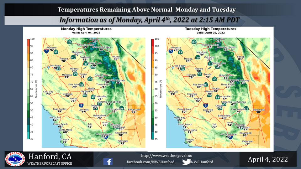
Mariposa Projected High Temperatures for Monday and Tuesday: 70 Degrees
Oakhurst Projected High Temperatures for Monday and Tuesday Range from 72-73 Degrees
Yosemite Valley Projected High Temperatures for Monday and Tuesday Range from 69-70 Degrees
Related: Weather Service Reports Major Warming Trend This Week With High Temperatures Running 20 to 23 Degrees Above Normal by Thursday
April 4, 2022 - The National Weather Service Hanford Office reports high temperatures throughout the area during the afternoon hours will be above normal for this time of year.
A slight warming trend is anticipated for the higher elevations on Tuesday.
  Area Forecast Discussion
  National Weather Service Hanford CA
  351 AM PDT Mon Apr 4 2022


  .SYNOPSIS...Temperatures will be slightly cooler today and Tuesday
  with breezy conditions continuing. A sharp warming trend will take
  place later this week with temperatures rising to around 20 degrees
  above normal. Record high temperatures are likely in the San Joaquin
  Valley on Thursday and Friday.

  &&

  .DISCUSSION...
  Satellite loops show clear skies across central California at this
  time though an area of high clouds is approaching from the north.
  The weak upper trough that moved through yesterday has shifted over
  the Desert Southwest. Onshore flow ramped up yesterday leading to
  strong wind gusts through the Kern County mountains into the Desert.
  Mojave is currently gusting around 45 mph. Guidance shows the winds
  decreasing later this morning but then ramping back up later today.
  A Wind Advisory remains in effect for the Mojave Desert Slopes and
  the Desert through 5 AM Tuesday. Temperatures will be slightly cooler
  today and Tuesday but are still forecast to be around 5 degrees above
  normal for early April.

  There continues to be good model agreement with a strong ridge of
  high pressure building in from the East Pacific later this week. A
  significant warming trend will result with high temperatures rising
  to around 12 degrees above normal on Wednesday. By Thursday, high
  temperatures across the San Joaquin Valley are forecast to be in the
  lower to middle 90s, which is around 20 to as much as 25 degrees
  above normal. Probabilistic guidance continues to show record high
  temperatures are likely in the SJ Valley. Merced has an 86% chance
  of a record high Thursday, Madera and Hanford have around an 80%
  chance, Fresno has a 72% chance, and Bakersfield has a 40% chance.
  Chances for record highs are similar on Friday with little changes
  expected.

  Ensemble guidance shows the ridge shifting east next weekend as an
  upper trough drops down over the Pacific Northwest. Slight cooling
  is expected on Saturday with high temperatures still forecast to be
  around 15 degrees above normal. The trough deepens over the west on
  Sunday and temperatures plunge back to near normal.

  &&

  .AVIATION...Areas of MVFR visibility in blowing dust in the Kern
  County Deserts. Otherwise, VFR conditions will prevail across the
  Central CA interior through at least the next 24 hours.

  &&

  .AIR QUALITY ISSUES...
  None.
Source: NWS
