


California and National Drought Summary for May 3, 2022
Summary
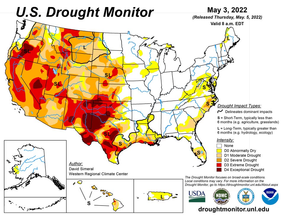
May 5, 2022 - This U.S. Drought Monitor (USDM) week was marked by ongoing active weather across areas of the conterminous U.S. including the Pacific Northwest, Northern Rockies, Plains, Lower Midwest, and isolated areas of the South and Southeast. The most severe weather was observed across the Central Plains and areas of the Midwest where numerous tornadoes touched down in areas including eastern Kansas, southeastern Nebraska, and northern Illinois. Widespread heavy rainfall accumulations were also observed, ranging from 2 to 7 inches, with the heaviest accumulations in eastern Nebraska. The rainfall events provided much-needed moisture to the region―boosting soil moisture levels across parched areas from Kansas to South Dakota. In the West, fast-moving storm systems delivered late season high-elevation snowfall to the Cascades of northern Oregon and Washington, the Northern and Central Rockies, and areas of the northern Great Basin. The highest snowfall totals (8 to 12+ inches) were observed in the Salmon River Mountains of Idaho, the Ruby Mountains of northeastern Nevada, and the Wind River Range of Wyoming. In California and the Southwest, conditions were dry during the past week with strong winds observed across the region. The windy, dry conditions exacerbated fire-weather conditions in Arizona and New Mexico where several large early-season wildfires are currently impacting the region. In northern New Mexico, the Hermits Peak Fire, situated east of Santa Fe in the Sangre de Cristo Mountains, has burned 147,909 acres and is only 20% contained (May 4), according to the National Interagency Coordination Center. On the water-resource front, the Colorado River Basin water situation continues to deteriorate due to the long-term impacts of drought with water levels at Lake Powell and Lake Mead currently at 24% full and 31% full, respectively. With Lake Powell’s water surface elevation currently at 3,522 feet, it is quickly approaching the 3,490-foot threshold level at which Glen Canyon Dam can continue to generate hydropower. The U.S. Bureau of Reclamation (USBR) announced (May 3) two urgent drought response actions to help bolster water levels at Lake Powell. The plan includes additional upstream releases from the Flaming Gorge Reservoir (~500,000 acre-feet [kaf] of water) as well as reducing Glen Canyon Dam’s annual release volume from 7.48-million acre-feet to 7 million acre-feet. In terms of this week’s map, short-term precipitation led to targeted improvements in the Pacific Northwest, Central Plains, South, and the Southeast, while degradations were registered in the Southwest, Texas, Southeast, and the Mid-Atlantic.
Northeast
The region remained drought-free with only ~1% experiencing drought conditions on the map. Minor improvements were made this week in an area of Abnormally Dry (D0) in southwestern Pennsylvania. In the short-term (past 30-day period), precipitation has been above normal across western and far-eastern portions of Pennsylvania as well as in areas of New England including eastern New York, Vermont, and southern Maine. According to the latest soil moisture data from NASA Crop-CASMA (Crop Condition and Soil Moisture Analytics), positive soil moisture anomalies were observed across most of the region except for some dry pockets in northern New Hampshire, west-central Maine, and along the coastal areas in Massachusetts, Rhode Island, and eastern Connecticut. In addition, the dryness is showing up in the 7-day average streamflows in these areas where numerous rivers and streams are below the 24th percentile.
Southeast
During the past week, light rainfall accumulations (generally < 1-inch) were observed across isolated areas of Alabama, Georgia, and the Carolinas, while heavier accumulations were observed in southern Florida where totals ranged from 1 to 6+ inches. Rainfall in Florida led to improvements in areas of Moderate Drought (D1) and Severe Drought (D2). Conversely, short-term dryness and declining soil moisture levels expanded Moderate Drought (D1) in Georgia and Virginia as well as Severe Drought (D2) in North Carolina. Streamflow levels across the Mid-Atlantic states have declined well below normal levels with numerous rivers and streams dipping below the 10th percentile range. Average temperatures for the week were slightly above normal across Alabama, Georgia, Florida, and South Carolina (1 to 6 deg F), while much of North Carolina and Virginia experienced below normal levels (1 to 8 deg F).
South
In the South, conditions on the map were a mixed bag of improvements and degradations. In southern Louisiana, isolated areas of light-to-moderate rainfall (2 to 4 inches) improved areas of Moderate Drought (D1), Severe Drought (D2), and Extreme Drought (D3) as well as eliminated pockets of Moderate Drought (D1) in northern Louisiana and southern Arkansas. In areas of Texas (Panhandle, north-central, west-central, Trans-Pecos), isolated bands of heavy rainfall (2 to 4 inches) helped to improve drought-affected areas. Conversely, the combination of above-normal temperatures, dry soils, and increased evaporative demand led to degradation in areas of the Panhandle, southeastern Texas, and the Trans-Pecos. In the Panhandle of Oklahoma, small areas of Exceptional Drought (D4) expanded in response to short-term rainfall deficits. Reports in this area include very poor rangeland conditions and local ranchers having to rely on supplemental feed for cattle. According to the latest USDA Oklahoma Crop Progress and Conditions report (May 2), wheat crop conditions were rated 51% poor to very poor and soil moisture was 63% short to very short. For the week, average temperatures were mostly above normal (2 to 8+ deg F) with the greatest positive anomalies observed across Texas and western Oklahoma.
Midwest
On this week’s map, minor changes were made including reduction in areas of Abnormally Dry (D0) in Minnesota in response to storm activity which brought 2 to 3 inches of rain to isolated areas of southern Minnesota. Overall, the region has been drought-free with exception of a few dry pockets in western Iowa. Precipitation was generally restricted to the western half of the region with some heavy accumulations (2 to 5 inches) observed in association with severe storms that impacted the Central Plains and areas of the Midwest including Missouri, Iowa, southern Minnesota, and northern Illinois. Average temperatures were below normal (2 to 10+ deg F) across the region, with the largest departures observed in the Upper Midwest. Midwest stream flows (7-day average) were running at normal to above-normal levels with extremely high flows observed in northern Minnesota, according to the USGS.
High Plains
On this week’s map, widespread improvements were made in South Dakota, Nebraska, and Kansas in response to significant rainfall accumulations that helped to improve soil moisture levels and boosted streamflow levels. Rainfall totals for the week ranged from 2 to 8+ inches with the highest totals observed in central South Dakota, eastern and central Nebraska, and northern Kansas. However, some drought-stricken areas of the region, including extreme southeastern South Dakota, northeastern Nebraska, and central Kansas, largely missed out on this week’s storms. In the eastern plains of Montana, improving conditions (precipitation, soil moisture) led to reduction in areas of Severe Drought (D2) and Extreme Drought (D3). However, it should be noted that recent improvements in eastern Montana are not uniform and many areas are still coping with the impacts (agricultural) of the longer-term drought situation. Average temperatures were below normal across the northern half of the region, with negative departures ranging from 2 to 10+ deg F below normal and the greatest departures observed in eastern portions of the Dakotas. In the southern half of the region, average temperatures were 2 to 8 deg F above normal.
West
Out West, several storm systems moved through the norther tier of the region bringing light to moderate snowfall accumulations to the higher elevations of the Cascades, northern Great Basin, and the Central and Northern Rockies as well as light rainfall to coastal areas and low-lying inland valleys of Idaho, Oregon, and Washington. Improvements were made in areas of Moderate Drought (D1), Severe Drought (D2), Extreme Drought (D3), and Exceptional Drought (D4) in Oregon in response to a combination of factors including normal to above-normal SWE, recent storm events, and improved soil moisture levels and streamflows. Likewise, improving conditions in northern Wyoming led to removal of areas of Extreme Drought (D3) in the Big Horn Mountains where current SWE is 108% of median. Elsewhere, conditions deteriorated on the map in northwestern Arizona and across much of New Mexico. Looking at snowpack data across the West at a regional scale (2-digit HUC), the NRCS SNOTEL network (May 3) reported the following median SWE levels: Pacific Northwest 111%, Missouri 99%, Souris-Red-Rainy 116%, California 60%, Great Basin 62%, Upper Colorado 76%, Arkansas-White-Red 50%, Lower Colorado 36%, and Rio Grande 33%. According to NRCS National Water and Climate Center’s reservoir summary report (April 1), statewide reservoir storage levels were below normal in all western states with exception of Washington state. In California, the state’s two largest reservoirs are at critically low levels moving into the dry season with Shasta Lake currently at 40% of total capacity on May 3 and Lake Oroville at 55% of capacity. In Southern California, the Metropolitan Water District of Southern California announced (April 27) that one-third of its users will be subject to restrictions that limit outdoor watering to one day per week as a measure to reduce water usage. In the Colorado River Basin, Lake Powell was at 24% of capacity and Lake Mead 31% of capacity on May 3, according to the USBR. In the Rio Grande Basin, New Mexico’s Elephant Butte Reservoir was 13% full.
Caribbean
In Puerto Rico, areas of Abnormally Dry (D0) were added to the map across the Cordillera Central as well as along the northern coastal plains. For the last 30-days, precipitation across these areas has been below normal with rainfall deficits ranging from 1 to 5+ inches.
On St. Thomas, Cyril E. King Airport reported 0.99 inches of rain this week, and groundwater levels slightly improved. Short-term precipitation statistics suggest near-normal conditions, while long-term data (9 and 12 months) suggest some lingering dryness. Thus, the drought depiction for St. Thomas was improved from moderate long-term drought to long-term abnormal dryness. On St. John, 1.45 inches of rain was reported at Windswept Beach this week. One- and three-month precipitation is near normal now, while precipitation at 6 and 9 months is abnormally dry. Groundwater has also stabilized with the rainfall this week. Therefore, the drought depiction has been improved from short- and long-term moderate drought to short- and long-term abnormal dryness. On St. Croix, 0.32 inches of rain was reported at Henry Rohlsen Airport. Little change in groundwater levels was seen this week, though the overall trend over the last month is still downward. Severe short- and long-term drought continues there.
Pacific
In the Hawaiian Islands, some windward locations across the island chain have received beneficial rainfall in association with a trade wind pattern. On the map, the only significant change was the removal of an area of Extreme Drought (D3) on the southwest flank of Maui. During the past 30-day period, above-normal rainfall has been observed across much of the Big Island, southeast Maui, and the leeward side of Kauai, while the rest of the island chain was below normal, especially on Molokai.
In Alaska, no changes were made on the map this week and the state remained drought-free. According to the NRCS SNOTEL network, most of the basins in Alaska were reporting above-normal SWE (May 3) including Koyukuk River (103% of median), Beaver Creek-Yukon River (373%), Tanana River (386%), Susitna River (324%), Copper River (169%), White River-Yukon River (262%), Knik Arm (149%), Prince William Sound (152%), Kenai Peninsula (125%), Northern Southeast Alaska (135%), and Central Southeast Alaska (135%). Conversely, below-normal SWE was reported in the Noatak River-Lisburne Peninsula (88%).
This week in American Samoa, rainfall varied from 0.42 inches at Toa Ridge to 0.99 inches at Siufaga Ridge to 1.74 inches at Pago Pago. Rainfall over the last several months has exceeded 4 inches at these three monitoring sites, and drought-free conditions have continued.
The Palau airport recorded 6.47 inches of rain this week, and the COOP station recorded 3.56 inches. Drought-free conditions continued.
Rainfall totals were small on Saipan this week, ranging from 0.02 to 0.14 inches. This followed only 0.27 inches of rain last week. However, drought-free conditions continued since March and April rainfall both exceeded 4 inches. Dry weather occurred on Rota this week, with only 0.15 inches of rain falling. However, April rainfall totaled 11.26 inches, so Rota remained free of drought. On Guam, the dry recent weather continued, with only 0.16 inches of rain falling this week, after only 0.84 inches fell last week. A few wildfires were observed on the southern half of Guam as well, though they were contained. The recent dryness has not quite reached abnormally dry levels, as April rainfall totaled 4.74 inches.
On Kwajalein, 8.21 inches of rain fell in April. Only 0.56 inches were recorded this week, but given the wet April, drought-free conditions continued. The weather was relatively drier on Ailinglapalap this week, with 1.18 inches of rain following four consecutive weeks of at least 6 inches of rain, and drought-free conditions continued. Jaluit received 2.22 inches of rain this week, after just under 12 inches fell in April, and drought-free conditions continued. Dry weather continued on Wotje, where severe short- and long-term drought is ongoing. Only 0.43 inches of rain fell on Majuro this week, but this followed about 24 inches in April, so drought-free conditions continued. On Mili, 2.6 inches of rain fell, continuing a long streak of weeks with at least 2 inches of rain dating back to late February. Drought-free conditions continued there. No data were reported on Utirik this week, so no drought depiction is being made there.
On Yap, 2.19 inches of rain fell this week, following a wet April with 14.28 inches, and drought-free conditions continued. This week, Ulithi received 1.15 inches of rain after 22.71 inches fell in April, and drought-free conditions continued. In Woleai, 3.36 inches of rain fell this week, and drought-free conditions continued. At Chuuk, over 11 inches of rain fell, so drought-free conditions continued. In Lukunor, 11.82 inches of rain fell, and drought-free conditions continued there too. Nukuoro reported 7.17 inches of rain, and drought-free conditions continued. In Kapingamarangi, 3.39 inches of rain fell this week, breaking a drier span of weather since the middle of March. Short-term abnormal dryness was improved to no drought or dryness, as there have not been any water concerns reported on the island. Wetter than normal weather has been the rule in Pohnpei for the last three months, and that continued this week with 4.67 inches of rainfall. Pingelap reported 1.65 inches of rain this week, the lowest amount since late February. With almost double normal rainfall having occurred in March and April, drought-free conditions continued another week. On Kosrae, recent wet weather continued with 4.73 inches of rain falling this week. No data were reported on Fananu this week, so no drought depiction was made there.
Looking Ahead
The NWS WPC 7-Day Quantitative Precipitation Forecast (QPF) calls for moderate-to-heavy liquid (liquid = rain + SWE) precipitation accumulations ranging from 2 to 5+ inches across eastern portions of the Central and Southern Plains and the Lower Mississippi Valley. In the Lower Midwest and the Mid-Atlantic, precipitation totals are expected to range from 1 to 3 inches. Out West, accumulations ranging from 1 to 5 inches are forecasted for the coastal ranges and the Cascades of western Oregon and Washington. Further inland, lighter accumulations (< 2 inches) are expected in the Northern Rockies of Idaho, Montana, and Wyoming. Further south, conditions are expected to be dry across California, the Great Basin, and the Desert Southwest. The CPC 6-10-day Outlooks calls for a moderate-to-high probability of above-normal temperatures across the eastern two-thirds of the conterminous U.S. with exception of some coastal areas of the Mid-Atlantic and Florida. Below-normal temperatures are expected across much of the West with exception of eastern portions of Colorado and New Mexico where there is a low-to-moderate probability of above-normal temperatures. In terms of precipitation, the wetter-than-normal pattern is expected to persist across the northern tier of the West as well as in areas of the Great Plains. In coastal areas of the Far West, near-normal precipitation is expected. Across much of the eastern half of the conterminous U.S., including areas of the Southern Plains, Lower Midwest, Mid-Atlantic, and the Northeast, there is a moderate-to-high probability of below-normal precipitation.
Author(s):
David Simeral, Western Regional Climate Center
Curtis Riganti, National Drought Mitigation Center
Dryness Categories
D0 Abnormally Dry—used for areas showing dryness but not yet in drought, or for areas recovering from drought.
Drought Intensity Categories
D1 Moderate Drought
D2 Severe Drought
D3 Extreme Drought
D4 Exceptional Drought
Drought or Dryness Types
S Short-term, typically less than 6 months (agriculture, grasslands)
L Long-term, typically more than 6 months (hydrology, ecology)
SL Area contains both short- and long-term impacts
Source: National Drought Mitigation Center
