


California and National Drought Summary for May 10, 2022
Summary
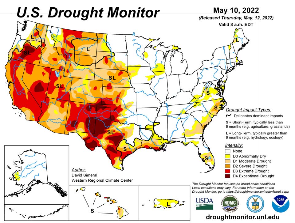
May 12, 2022 - This U.S. Drought Monitor (USDM) week saw continued improvements on the map across the Pacific Northwest and the northern Plains in response to another round of unsettled weather during the past week. In the Pacific Northwest, Northern California, and the northern half of the Intermountain West, a series of disturbances starting last weekend brought cold temperatures and significant snowfall accumulations to the higher elevations of the Cascades, Klamath Mountains, Sierra Nevada, ranges of the northern Great Basin, and the Northern Rockies. Storm totals ranged from 6 to 18+ inches, providing a much-needed boost to mountain snowpack levels. In addition to the late-season snowfall, temperatures plummeted well below normal levels. Minimum temperatures dipped into the teens in the Sierra Nevada as well as across areas of the Intermountain West including Peter Sinks, Utah (Bear River Mountains of northern Utah), which registered the national low of 7 deg F on May 11, according to the National Weather Service Weather Prediction Center. In Northern California, recent storms and cooler temperatures helped to temporarily delay further deterioration of the already shallow snowpack, which was only 22% of normal statewide on May 11. In the Southwest, unseasonably warm, dry, and windy conditions exacerbated fire-weather conditions where nine large fires are currently impacting the region, including the Hermits Peak Fire which has scorched ~204,000 acres (43% contained) in the southern Sangre de Cristo Range, northeast of Santa Fe, New Mexico. In the northern and central Plains, isolated showers, and thunderstorm activity led to continued modest improvements in drought-related conditions. Meanwhile, in the southern Plains and Texas, the first heat wave of the season brought 90 to 110+ deg F temperatures to the region as well as periods of critical fire-weather conditions. In eastern portions of the southern Plains, isolated heavy rainfall accumulations (3 to 8+ inches) helped to ease drought conditions. However, drought-stricken areas of western Kansas and Oklahoma largely missed out on recent storm events. In the Midwest, light to moderate rainfall accumulations (1 to 5 inches) were observed in the southern and western portion of the region this week with most of the region remaining drought-free. In the Mid-Atlantic, rainfall accumulations ranging from 2 to 4 inches across areas of Pennsylvania, Maryland, northern Virginia, and West Virginia boosted area streamflows and helped to improve drought-related conditions on the map. In the Southeast, short-term dryness during the past 30 to 90 days led to minor degradations in the Lower Savannah River Basin along the Georgia-South Carolina border, while another round of isolated storms in southern Florida led to improvements in drought-affected areas.
Northeast
For the week, only minor degradations were made on the map including in eastern Massachusetts where an area of Abnormally Dry (D0) was introduced in response to short-term rainfall deficits (past 60-day period) and declining streamflow levels. In this area, precipitation deficits ranged from 2 to 3 inches. Further south, improvements in areas of Abnormally Dry (D0) were made in Delaware, Maryland, southern Pennsylvania, and West Virginia in response to rainfall accumulations ranging from 2 to 4 inches this week. For the week, average temperatures were 1 to 6 deg F below normal across the region. Looking at the latest climatological rankings from NOAA NCEI, the Northeast climate region experienced its 38th wettest (of 128 years) January-April period on record and its 39th warmest for the same period. For the past 12-month period (May 2021-April 2022), the region saw its 9th warmest on record in terms of average maximum temperatures with a +2.5 deg F anomaly. For precipitation, it was the 14th wettest (+6.36-inch anomaly) for the contemporaneous period. At a state level, April 2022 precipitation was normal to above normal across the region with Vermont having its 12th wettest April on record (+1.69-inch anomaly).
Southeast
During the past week, light rainfall accumulations (< 2 inches) were observed across isolated areas of Alabama, Georgia, Florida, and South Carolina while heavier accumulations (2 to 4 inches) were observed in isolated areas of eastern North Carolina and northern Virginia. This week’s rainfall led to minor improvements on the map in Virginia as well as in southern Florida. In southern Florida, precipitation deficits for the past 90-day period ranged from 2 to 6 inches. In the Lower Savannah River Basin, short-term (past 30-90 days) precipitation shortfalls, low streamflows (10-24th percentile), and dry soils led to introduction of an area of Severe Drought (D2). Similarly, in the Coastal Plain of North Carolina, 7-day streamflows have been well below normal levels with numerous streams/rivers dipping below the 10th percentile. According to NOAA NCEI’s statewide climatological rankings, the March-April 2022 period was the 35th driest on record for both North Carolina and Virginia. Likewise, precipitation for the past 12-month period was below normal for North Carolina (28th driest, -4.49-inch anomaly) and Virginia (35th driest, -2.84-inch anomaly), while wetter-than-normal conditions were observed in Alabama (9th wettest, +11.10-inch anomaly) and in Georgia (35th wettest, +4.06-inch anomaly).
South
In the South, drought-related conditions improved in eastern Oklahoma and areas of northeastern Texas. In eastern Oklahoma, very heavy rainfall accumulations (ranging from 3 to 8+ inches) led to improvements on the map. However, this week’s heavy rains largely missed the western part of the state. Likewise, much of the western half of Texas was very dry combined with extreme heat, leading to further expansion of areas of Extreme Drought (D3) and Exceptional Drought (D4). Average temperatures across the region were well above normal. The most extreme heat was observed across Texas (6 to 10+ deg F above normal) with high temperatures soaring over 110 deg F in the Trans-Pecos region. Since last Tuesday (May 3), Big Bend Village (Big Bend National Park) logged the national high temperature six out of the seven days, with highs ranging from 102 to 112 deg F. Likewise, the heat wave that impacted much of the region saw temperatures rise above 100 deg in the southern Plains. The excessive heat this week continued to dry out already parched soils across much of Texas as well as in western Oklahoma where negative soil moisture anomalies (20th percentile) showed up on various soil moisture models. Moreover, 7-day streamflows at numerous gaging stations across the Hill Country of Texas and southwestern Oklahoma dipped below the 10th percentile, according to the U.S. Geological Survey. Also notable, Oklahoma saw its windiest April on record (1994-present) statewide, according to the Oklahoma Mesonet. According to NOAA NCEI, average temperatures were above normal across Texas, Oklahoma, and Louisiana with Texas logging its 11th warmest (+4 deg F anomaly) April on record.
Midwest
For the week, light to moderate (1 to 4 inches) rainfall accumulations were observed across western and southern portions of the region with higher totals in extreme southwestern Missouri. Only minor changes were made on the map with improvements in areas of Abnormally Dry (D0) in Minnesota and Kentucky as well as in areas of Moderate Drought (D1) in Iowa. Average temperatures for the week were below normal (1 to 6 deg F) across most of the region except for areas of Minnesota and northern Wisconsin where temperatures ranged from 2 to 10 deg F above normal. According to NOAA NCEI, average temperatures were below normal across the region during April, with Minnesota experiencing its 10th coldest (-5.5 deg F anomaly) and Iowa its 13th coldest (-4.3 deg F anomaly) April on record. In terms of precipitation, above-normal precipitation for April was observed in Minnesota (7th wettest), Missouri (40th wettest), Wisconsin (35th wettest), and in Michigan (24th wettest). Since the beginning of the cool season (October 2021), precipitation was above normal across the entire region with the greatest statewide precipitation anomaly observed in Minnesota (7th wettest).
High Plains
On this week’s map, improvement in drought conditions continued on the map in areas of eastern Kansas, Nebraska and eastern South Dakota where another round of storms helped to alleviate short-term deficits as well as provide a modest boost to soil moisture levels and streamflows. However, the longer-term impacts of the drought in western portions of the region are still causing impacts including areas with poor pasture and rangeland conditions and low stock pond levels. In eastern Colorado, conditions degraded in response to continued dryness over the past several months with reports of little new growth of grasses, blowing sand and dust, and very dry soils as well as crops being abandoned in some areas, according to the Colorado Climate Center. For the week, average temperatures were above normal across most of the region with positive departures ranging from 2 to 8+ deg F and the greatest departures observed in eastern portions of Colorado and Montana. According to NOAA NCEI, North Dakota logged its 2nd wettest (+2.3-inch anomaly) April on record (as evidenced in severe flooding observed in eastern portions of the state). Likewise, precipitation in South Dakota and Montana was also both above normal (32nd wettest) for April. In contrast, April was very dry, with Kansas seeing its 3rd driest and Colorado its 5th driest on record.
West
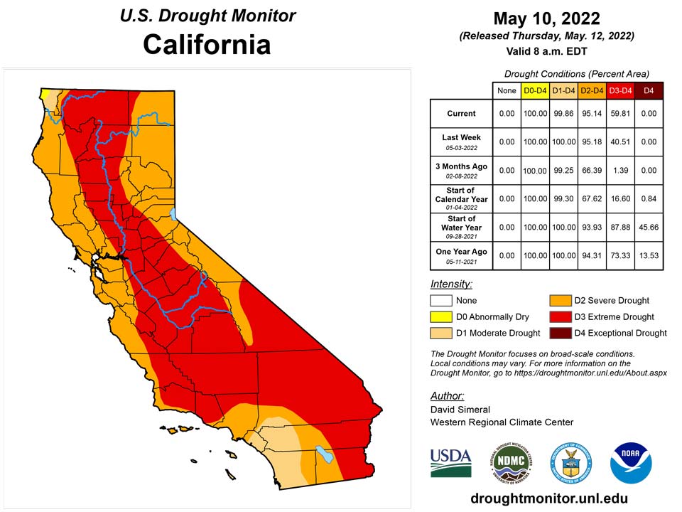
Another round of Pacific storms impacted northern portions of the region with beneficial late-season snowfall observed in the Cascades, Klamath Mountains, Sierra Nevada, ranges of the northern Great Basin, and the central and northern Rockies. In response, improvements were made on the map in Oregon, Washington, Idaho, and Montana. In Northern California, precipitation has been above normal during the past 30-day period. However, the recent precipitation did little to make up for significant shortfalls observed since January 1 as well as in the broader longer-term context with 20+ inch precipitation deficits across Northern California during the past 24-month period. According to NOAA NCEI statewide climatological rankings, the January-April 2022 period was the driest (-9.7-inch deficit) on record for California while the last 24-month period (May 2020-April 2022) was the 2nd driest on record. Looking at the latest region-level (2-digit HUC) snowpack data across the West, the NRCS SNOTEL network (May 10) was reporting the following median SWE levels: Pacific Northwest 124%, Missouri 96%, Souris-Red-Rainy 113%, California 68%, Great Basin 61%, Upper Colorado 66%, Arkansas-White-Red 30%, Lower Colorado 10%, and Rio Grande 18%. According to NRCS National Water and Climate Center’s reservoir summary report (May 1), statewide reservoir storage levels remained below normal across all western states with exception of Washington state. In the Colorado River Basin, Lake Powell was at 24% of capacity and Lake Mead 30% of capacity on May 10, according to the USBR. In the Rio Grande Basin, New Mexico’s Elephant Butte Reservoir was 13% full and Caballo Reservoir 10% full. In Arizona, the Salt River system was 76% full while the Verde system was 33% full with the total system at 71% full―down 2% from a year ago, according to the Salt River Project. Looking at region-level climatological rankings, the West Climate Region (California and Nevada) logged its driest January-April period on record while the Southwest Climate Region (4-Corners states) observed their 3rd driest. Longer-term, the May 2020-April 2022 period was the driest on record for the Southwest Climate Region and the 2nd driest for the West Climate Region.
Caribbean
In Puerto Rico, no changes were made on the map this week.
Dry weather enveloped the U.S. Virgin Islands this week. St. Croix only received 0.04 inches of rain, and groundwater levels remained low but mostly constant. Severe short- and long-term drought continued this week. On St. Thomas, 0.15 inches of rain was reported, and groundwater continued to recede after increasing a couple of weeks ago. Long-term abnormal dryness continued as long-term precipitation deficits continued. Short- and long-term abnormal dryness continued on St. John this week, after rain totaled only 0.13 inches at Windswept Beach and groundwater levels slowly decreased.
Pacific
In the Hawaiian Islands, conditions were relatively wet across the island chain. However, most of the precipitation occurred over the east-facing slopes with the leeward areas receiving considerably less precipitation. The recent trade wind pattern of precipitation has led to sharp precipitation and drought-related gradients across the islands. This week, some degradations were made on the leeward sides of Molokai and the Big Island, while some minor improvements were made on the windward sides of Kauai and Oahu.
In Alaska, no changes were made on the map this week and the state remained drought-free. According to the NRCS SNOTEL network, sub-region level (4-digit HUC) water-year-to-date precipitation is as follows: Arctic Alaska (102%), Northwest Alaska (77%), Lower Yukon River (108%), Middle Yukon River (162%), Upper Yukon (120%), Southwest Alaska (271%), South Central Alaska (102%), and Southeast Alaska (109%).
This week’s weather in American Samoa was a bit drier than last week. The highest rainfall total was 1.14 inches at Pago Pago, while Siufaga Ridge and Toa Ridge totaled 0.31 and 0.20 inches, respectively. American Samoa remained free of drought or abnormal dryness.
This week was very wet in Palau. The Koror cooperative observer reported 6.09 inches of rain, with one day missing from the record, while the Palau airport reported 11.18 inches of rain. Palau remained free of drought or abnormal dryness.
The Mariana Islands remained free of drought and abnormal dryness this week. Rainfall amounts varied widely on Saipan. The airport recorded at least 1.41 inches of rain (with 2 days missing), while the ASOS and NPS reports were only 0.40 and 0.10 inches, respectively. Dry conditions for the last few weeks continued on Guam, where only 0.34 inches of rain was reported (with one day missing), marking the third straight week with less than an inch of rain. However, given the 4.74 inches of rain that fell in April, which was also above normal for the month, abnormal dryness has not developed. Drier weather also occurred on Rota this week, with 0.37 inches of rain being reported (with one day missing) following only 0.15 inches last week. However, April rainfall totaled over 11 inches, so abnormal dryness has not developed.
The Federated States of Micronesia remained free of drought and abnormal dryness this week at all locations for which depictions were made. On Yap, wet recent weather continued as 5.03 inches of rain fell this week. In Ulithi, rain reports totaled 0.24 inches, though with 2 days missing. At least 4.34 inches of rain was reported on Woleai this week. No depiction was made for Fananu, as data from there are missing. At Chuuk, wet recent weather continued, with 4.52 inches of rain falling this week. On Lukunor, 2.27 inches of rain fell this week, following almost 12 inches of rain last week. On Nukuoro, conditions remained wet this week, with 4 inches of rain. On Kapingamarangi, the weather was dry this week, with no rain being reported, but April rainfall totaled almost 9 inches. Pohnpei received 6.24 inches of rain this week, continuing wet recent weather there. The weather has dried a bit the last two weeks on Pingelap, with 0.66 inches of rain this week following 1.65 inches last week. However, April rainfall totaled over 23 inches, so no abnormal dryness has developed. Rain totaled at least 9.10 inches on Kosrae this week.
Kwajalein reported 3.56 inches of rain this week, following a drier 0.56 inches last week, and drought-free conditions continued. On Ailinglapalap, 2.52 inches of rain was reported, following over 24 inches in April, and drought-free conditions continued. Jaluit reported 0.56 inches of rain over the course of three days this week (four days were missing). Given that 2.22 inches of rain fell last week, and that April rain totaled over 12 inches, a drought-free depiction is being made this week. No depiction was made for Utirik, as all recent data are missing. Rain totaled 1.88 inches on Wotje this week; while this is still below the weekly minimum of 2 inches, it was enough to prevent conditions from degrading, so severe short- and long-term drought continued this week. Only 1.38 inches of rain were reported on Majuro this week, following only 0.44 inches last week. However, April rain totaled 24.16 inches, and Majuro remained free of drought and abnormal dryness. Mili received 2.55 inches of rain this week, following a wet April with 28.49 inches of rain, and drought-free conditions continued.
Looking Ahead
The NWS WPC 7-Day Quantitative Precipitation Forecast (QPF) calls for moderate-to-heavy liquid (liquid = rain + SWE) precipitation accumulations ranging from 2 to 5+ inches across western portions of Oregon and Washington while lighter accumulations (< 1 inch) are forecasted for areas of the Northern Rockies. The remainder of the West is expected to be dry during the next 7-day period. In northern portions of the High Plains, light to moderate accumulations (generally < 3 inches) are expected while light accumulations (< 1 inch) are forecasted for areas of the Midwest, South, Mid-Atlantic, and the Northeast. The CPC 6-10-day Outlooks calls for a moderate-to-high probability of above-normal temperatures across the lower two-thirds of the conterminous U.S., while below-normal temperatures are expected across the Pacific Northwest and the Upper Midwest. In terms of precipitation, below-normal precipitation is expected across Northern California, much of the Intermountain West and Southwest, South, and the Upper Great Lakes region. Conversely, above-normal precipitation is forecasted for portions of the Pacific Northwest and the northern Plains.
Author(s):
David Simeral, Western Regional Climate Center
Curtis Riganti, National Drought Mitigation Center
Dryness Categories
D0 Abnormally Dry—used for areas showing dryness but not yet in drought, or for areas recovering from drought.
Drought Intensity Categories
D1 Moderate Drought
D2 Severe Drought
D3 Extreme Drought
D4 Exceptional Drought
Drought or Dryness Types
S Short-term, typically less than 6 months (agriculture, grasslands)
L Long-term, typically more than 6 months (hydrology, ecology)
SL Area contains both short- and long-term impacts
Source: National Drought Mitigation Center
