


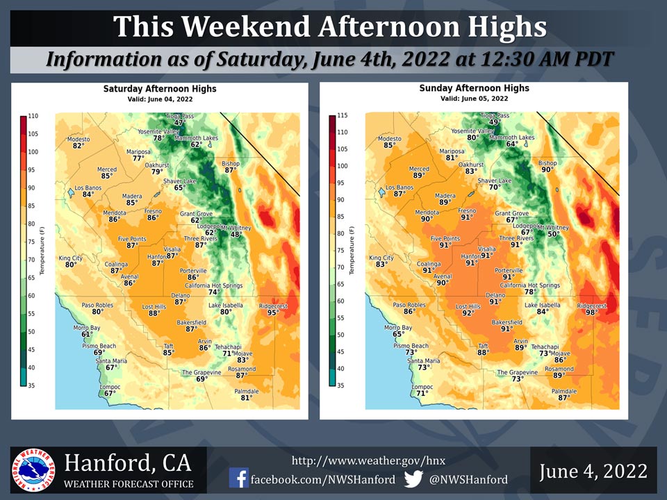
Mariposa Projected High Temperatures for Saturday and Sunday: 77-81 Degrees
Oakhurst Projected High Temperatures for Saturday and Sunday: 79-83 Degrees
Yosemite Valley Projected High Temperatures for Saturday and Sunday: 78-80 Degrees
June 4, 2022 - The National Weather Service Hanford Office reports afternoon highs will be around normal today, will rise a couple degrees tomorrow.
  Area Forecast Discussion
  National Weather Service Hanford CA
  1252 AM PDT Sat Jun 4 2022


  .SYNOPSIS...
  Cooler afternoon highs today as onshore flow continues. Breezy
  conditions look likely through and below the mountain passes in
  Kern County this afternoon lasting through the night. A shower or
  two will be possible this afternoon and again on Sunday afternoon
  near Yosemite National Park. A warming trend will begin by the
  middle of next week, taking afternoon highs well above average by
  the end of the forecast period.

  &&

  .DISCUSSION...
  Northwest breeze and cooler conditions prevail this morning as
  onshore flow continues. Afternoon highs will drop as a result,
  with highs only in the mid to upper 80s expected. Onshore
  gradients are forecast to strengthen a bit more this afternoon
  and evening, so have issued a Wind Advisory for the Mojave Desert
  Slopes starting at 2 PM this afternoon through 7 AM Sunday. This
  afternoon a light shower or two will be possible around YNP as
  some of the moisture from the trough to our north and associated
  lift reach the area. A couple of showers will be possible in the
  same area again tomorrow afternoon, however rainfall totals would
  be very light in any shower.

  The big story for next week will be the heat. As the Pacific
  Northwest trough begins to lift out of that area tomorrow,
  afternoon highs will begin to increase. Afternoon highs return to
  the lower 90s across the valley Monday, and rise into the mid 90s
  for Tuesday. EPS and GEFS ensemble guidance show a ridge building
  in the EPAC Wednesday, which may nudge highs into the upper 90s
  for us. The ridge is forecast to strengthen through the weekend,
  leading to additional warming. Triple digit heat is being
  predicted by the NBM next Thursday, with even hotter highs around
  105 for Friday across the SJV. Highs Saturday afternoon could
  nudge up a degree or two from Friday as the ridge builds even
  more. Heat-related headlines may be required for next week as
  afternoon highs could be 15-16 degrees above normal.


  &&


  .AVIATION...
  Wind gusts of 40-45 knots possible over the Tehachapi Mountains
  after 21z Saturday. VFR conditions will prevail throughout the
  Central California interior for at least the next 24 hours.

  &&

  .AIR QUALITY ISSUES...
  None.
Source: NWS
