


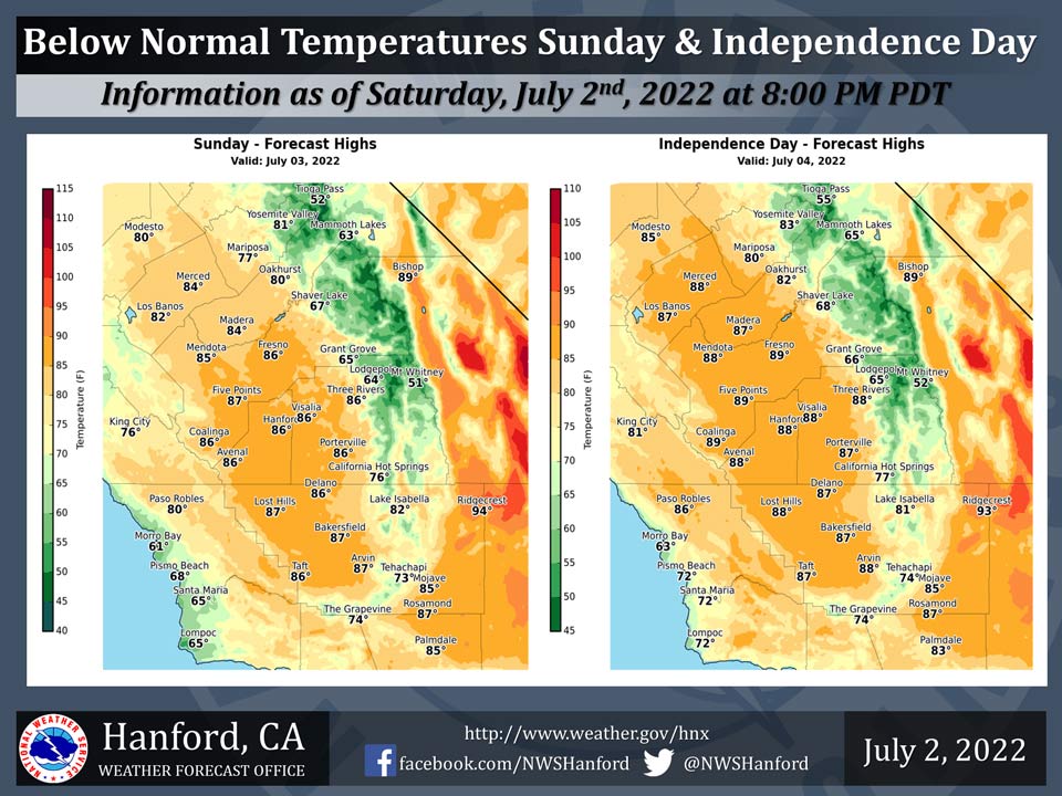
Mariposa projected high temperature for Sunday: 77 degrees, Monday: 80 degrees
Oakhurst projected high temperature for Sunday: 80 degrees, Monday: 82 degrees
Yosemite Valley projected high temperature for Sunday: 81 degrees, Monday: 83 degrees
July 3, 2022 - The National Weather Service Hanford Office reports high temperatures throughout Central California on Sunday and Independence Day will be around 5 to 10 degrees below normal for this time of the year.
Area Forecast Discussion
National Weather Service Hanford CA
310 AM PDT Sun Jul 3 2022
.SYNOPSIS...
Well below average temperatures will continue for the 4th of
July. A slow warming trend will commence on Tuesday through
Thursday. More pronounced warming is expected by the end of the
week as a ridge shifts westward over the region. There will be
periodic gusty winds in the afternoon and evening along the
coastal range and Kern mountains through at least Tuesday. Dry
weather will persist.
&&
.DISCUSSION...
A change in the weather pattern is occurring across the West
Coast as a disturbance approaches the Pacific Northwest. The
change is already being felt as the area observes cooler and
breezy conditions this morning. While precipitation will not reach
the Central California Interior, the disturbance allowed the heat
wave to end and will now generate breezy to locally windy
conditions across the area. Currently, surface pressure gradients
from KSFO to KLAS were reaching 10mb. With High-Res ensemble wind
gusts solutions showing potentially advisory level winds Sunday
evening, will issue a Wind Advisory for the Mojave Desert Slopes
from late this afternoon through Mid-day on Monday. Ensemble
solutions now call for a persistent disturbance to affect the
areas weather as triple digit temperatures will have to wait until
the end of the week.
In the short-term, High-Res ensemble place very low probability
that valley temperatures will reach max values of 90 degrees
today. These low probability adds to the confidence that cooler
air is surging into the region. Added support is observed in the
surface pressure gradient which has tighten to 10mb. Therefore,
ensemble surface wind gusts probability attempt to place strong
winds over the Eastern slopes of the Mojave Desert centered around
this evening. Before the cooler air enters the desert on Monday,
winds could potentially reach 50 mph. Ensemble solution places the
cooler air over most of the district on the 4th of July which
will reduce wind speed and provide us with below normal
temperatures.
Longer range ensemble solutions continue to show the West Coast
under cyclonic flow. With a ridge building over the middle of the
CONUS, the disturbance of the west may be blocked for several
days. Ensemble Cluster Analysis at the upper level shows the
persistent trough pattern over the West as a ridge builds to the
east. It is not until Friday and Saturday that probability of
exceedance of reach 100 degree or above finally shows significant
percentage values. Therefore, the return of the heat will be a
gradual step upward with temperatures in the 90s for a majority of
the time. While some ensemble members show surface temperature
values reaching 100 by Friday, it is not until Saturday that a
significant number of ensemble members reach the century mark. By
then, the ridge will have overtaken the region as another possible
heat-wave begins. Yet, the region remains dry.
&&
.AVIATION...
Surface winds are expected to increase and reach speeds of 35
knots over higher between 23Z today and 18Z Monday. Otherwise,
VFR conditions will prevail across the central CA interior for at
least the next 24 hours.
&&
.AIR QUALITY ISSUES...
None.
Source: NWS
