


California and National Drought Summary for July 19, 2022
Summary
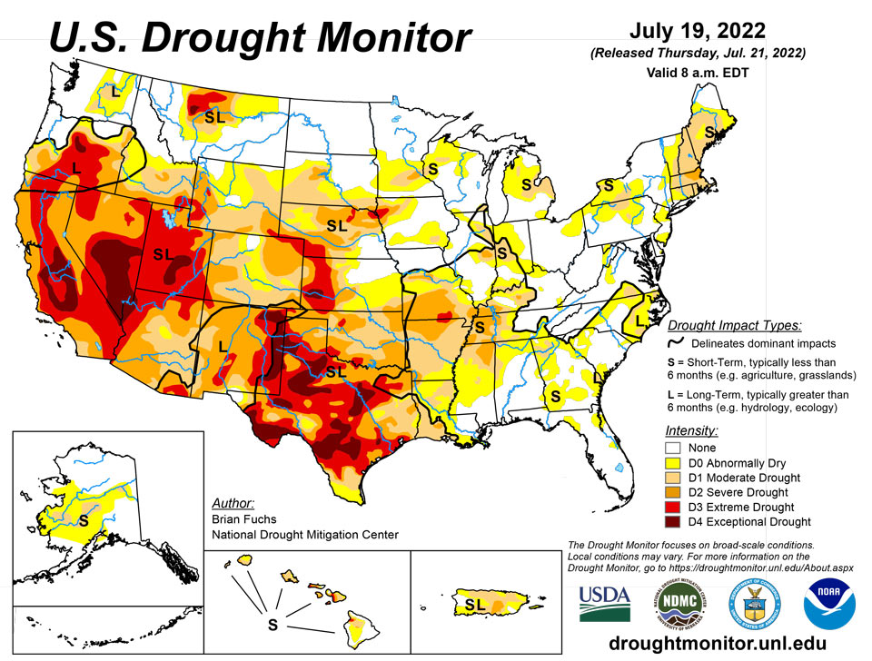
July 21, 2022 - Most of the eastern third of the U.S. recorded precipitation during the last week, with only a few pockets that missed out. Portions of the Midwest and into the Southeast had some amounts over 3 inches for the week and even widespread 5+ inch amounts in the coastal areas of Florida, and some rain at the end of the period allowed for much of New England to stay status quo for the week and even see a few improvements. The areas with the most rain also had the coolest temperatures, with much of the Midwest and Southeast cooler than normal for the week with departures of 2-4 degrees below normal. Warmer-than-normal temperatures dominated the western half of the country with areas from Montana to Texas recording temperatures that were 6-8 degrees above normal. The coastal areas of the Pacific Northwest were cooler than normal while the Great Basin was warmer than normal with departures of 6-8 degrees above normal. With the dryness and heat, the flash drought that has been developing in the central to southern Plains developed even more this week with the wet conditions of May and June quickly being forgotten.
Northeast
The coastal areas of the region were warmer than normal this week with departures of 2-4 degrees above normal common from New Jersey to Maine. A large rain event occurred through much of the region and allowed for some improvement to the abnormally dry conditions in New Jersey, southeast New York, and western Connecticut and slowed down degradation through New England. Improvements were also made to abnormally dry and moderate drought conditions in northern Vermont as well as to moderate drought in central Maine. The severe drought area in Massachusetts was expanded this week and abnormally dry conditions were expanded, and some new pockets of moderate drought conditions were introduced over western New York and northern Pennsylvania. Abnormally dry conditions were expanded out of central New Jersey and into extreme eastern Pennsylvania as a result of short-term dryness.
Southeast
Widespread precipitation through the region allowed for temperatures to be cooler than normal for most of the Southeast with departures of 1-3 degrees below normal. Pockets of heavier rain were recorded throughout Florida, Georgia, and into the Carolinas. Dry conditions continued to dominate areas along the Mississippi and Alabama borders as well as western Tennessee. In the Carolinas, widespread improvements were made to moderate drought and abnormally dry conditions. Some lingering long-term dryness remains along coastal regions, which did not allow for all the drought to be eliminated even with the good rains recently. Some expansion of moderate drought took place in eastern sections of Georgia and abnormally dry conditions were expanded in both Georgia and northern Alabama. Drought continued to intensify over western Tennessee, where moderate and severe drought expanded this week.
South
As with areas of the central Plains, the South had widespread hot and dry conditions for the week. Areas of northeast Arkansas, western Louisiana and northern Mississippi had the most rain, with pockets of rain throughout central and southern Texas. Temperatures were warmer than normal with departures of 4-6 degrees above normal over most of northern Texas and Oklahoma. As both long-term and short-term dryness have impacted this area, extreme and exceptional drought expanded over Oklahoma and Texas while flash drought development has impacted much of eastern Oklahoma into Arkansas. Widespread degradation took place this week with a full category degradation over much of Oklahoma, Arkansas and into northern Texas. Further degradation took place over portions of east Texas with just small areas of improvement over far west Texas, the western Panhandle and into southwest Texas.
Midwest
Another week where most of the eastern portions of the region recorded above-normal precipitation, with the greatest amounts through Kentucky, southern Illinois, southern Indiana and northern Ohio as well as in portions of northern Wisconsin. Temperatures were 1-3 degrees below normal in these areas of greatest precipitation, with the coolest readings over eastern Wisconsin and northern Ohio. Warmer-than-normal conditions were recorded from Minnesota to Missouri, where flash drought conditions continue to develop in the southern half of the state. Missouri had widespread degradation this week with most of the southern half of the state experiencing a full category degradation on the U.S. Drought Monitor. Severe drought expanded over western Kentucky while moderate drought expanded over central Minnesota. New areas of moderate drought were introduced into southeast Iowa and Michigan while a new area of severe drought was introduced into central Minnesota. Improvements were made to moderate drought and abnormally dry conditions over Illinois, Indiana, and Kentucky, with just a slight expansion of severe drought in eastern Illinois. Heavy rains over portions of northern Wisconsin allowed for improvements to moderate drought and abnormally dry conditions.
High Plains
A warm and mainly dry week dominated the region. Temperatures were warmest in eastern Montana and from western North Dakota to western Kansas, where departures were 6-8 degrees above normal. There were some pockets of very intense rains in Nebraska, North Dakota and eastern Colorado, but widespread rains were minimal. South Dakota had expansion of abnormally dry and moderate drought over much of the southern tier of the state while eastern Kansas had widespread introduction of abnormally dry conditions and moderate drought expansion. Severe and extreme drought expanded over much of western Kansas while severe drought expanded over north-central Nebraska and in the panhandle. Severe drought also expanded on the plains of eastern Colorado and extreme southeast Wyoming. There was a slight improvement in extreme drought in northeast Nebraska where some intense rains fell in the middle of the previous extreme drought area.
West
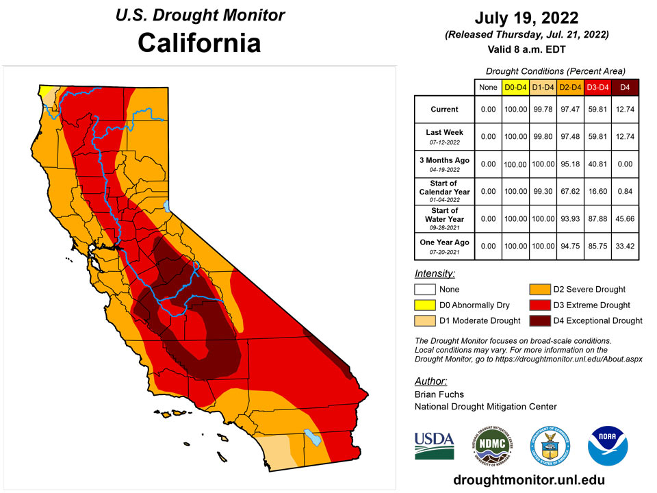
Temperatures were warmer than normal over much of Montana and into northern Nevada, southern Idaho, and eastern Wyoming with departures of 6-8 degrees above normal. Temperatures were cooler than normal by 1-2 degrees over the coastal regions of Washington and Oregon. Highly variable and scattered monsoonal moisture continues to impact the region, with some areas with above-normal precipitation for the week in Nevada, Arizona, and southern California as well as into areas of southern Colorado and Utah. Only minimal changes were made this week as the full impact of the recent precipitation is not fully known yet, but improvements are possible depending on how the rest of the monsoon season continues.
Caribbean
There was significant precipitation over the western side of Puerto Rico again this week, but unfortunately, it was in areas that are already drought free.
Short- and long-term severe and extreme drought continued across the US Virgin Islands this week. St. Thomas drought classification of severe drought continued since it had less than half an inch of rain across the island. The Cyril E King airport had only 0.26 inch of rain for the week, resulting in a month-to-date total that was 52.3% of normal and 76.2% of normal for year-to-date. SPI values at the 1, 3, 9 and 12 months were indicative of moderate to exceptional drought, while the 6-months period was indicative of abnormally dry conditions.
Similarly, St. John's drought classification of extreme drought (D3-SL) persisted since rainfall totals were also less than half an inch and SPI values at the 3, 6, 9, and 12 months were indicative of moderate to extreme drought. Month-to-date total at the Windswept Beach station was 74.5% of normal and 69.5% of normal for year-to-date.
St. Croix had the most rain at 1.15 inches for the week, resulting in a month-to-date of 151% of normal rainfall and 82.9% of normal for year-to-date. SPI values were indicative of moderate to exceptional drought at the 3, 6, 9, and 12 months. Despite the beneficial rains this week, extreme drought (D3-SL) continued since groundwater levels haven't improved, with the Adventure 28 well at its lowest level since 2016.
Pacific
Improvements were made in Alaska where recent rains helped to alleviate moderate drought as well as abnormally dry conditions across the southern portion of the state.
In Hawaii, the remnants of two tropical storm systems allowed for improvements to abnormally dry and moderate drought conditions on Maui and Molokai.
Drought free conditions persisted across Palau, Guam, and American Samoa since these locations received close to or over their weekly and monthly thresholds to meet most water needs. Most of the Federated States of Micronesia and Marshalls continued to be drought free as they had a very wet week, with the exception of Kapingamarangi and Majuro. Kapingamarangi had some much needed rain this week; however, its weekly rainfall total was less than 2 inches. According to the Drought Information Statement Issued by NWS Tiyan, Guam on July 9, vegetation was yellow and residents were conserving water. For this reason, Kapingamarangi's drought classification of long-term moderate drought was not changed. Abnormally dry conditions persisted across Majuro this week. Despite receiving over 2 inches of rain for the week, Majuro's reservoir levels were at 53.6% of the maximum of 36 million gallons as of June 15, which is less than the critical 80% threshold.
Looking Ahead
Over the next 5-7 days, it is anticipated that wet conditions will continue over the Southeast and along the Gulf Coast. Areas of the Midwest will also continue with the recent wet pattern, with the greatest rains anticipated over southern Wisconsin. Dry conditions will dominate the West and South and monsoonal moisture will continue to bring rains to the Four Corners region and into the central Plains. Temperatures during this time will be above normal for most of the country; the greatest departures of 6-9 degrees above normal will be over the West and into the Plains. Cooler-than-normal conditions will be experienced over the northern Plains, where temperatures in North Dakota are anticipated to be 6-9 degrees below normal.
The 6-10 day outlooks show that the West, South, Midwest and East Coast have the best chances to record above-normal temperatures, with the best chances over the South and Pacific Northwest. The best probability for below-normal temperatures will be over the northern Plains, southern Arizona and Alaska. The best chances of above-normal precipitation appear to be over the central to southern Plains, Southwest and Midwest, with the best chances over Kansas, Oklahoma, and Kentucky. Below-normal precipitation chances are best over the Pacific Northwest and into portions of the Southeast.
Author(s):
Brian Fuchs, National Drought Mitigation Center
Ahira Sanchez-Lugo, NOAA/NCEI
Dryness Categories
D0 Abnormally Dry—used for areas showing dryness but not yet in drought, or for areas recovering from drought.
Drought Intensity Categories
D1 Moderate Drought
D2 Severe Drought
D3 Extreme Drought
D4 Exceptional Drought
Drought or Dryness Types
S Short-term, typically less than 6 months (agriculture, grasslands)
L Long-term, typically more than 6 months (hydrology, ecology)
SL Area contains both short- and long-term impacts
Source: National Drought Mitigation Center
