


Includes Eastern Madera and Mariposa Counties and Yosemite National Park
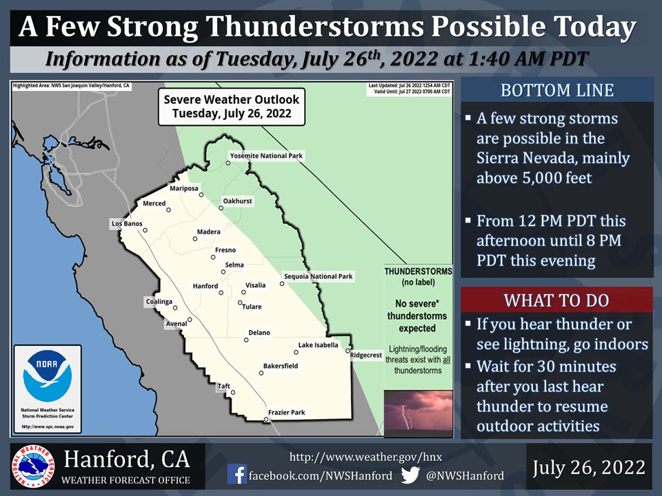
July 26, 2022 - The National Weather Service Hanford Office reports a few strong thunderstorms are possible in the Sierra Nevada, mainly above 5,000 feet, from 12:00 P.M. this afternoon until 8:00 P.M. this evening.Dangerous cloud to ground lightning strikes, wind gusts near 45 mph, and small hail are hazards associated with strong thunderstorms.
Area Forecast Discussion
National Weather Service Hanford CA
310 AM PDT Tue Jul 26 2022
.SYNOPSIS...
Triple digit heat in the valley and Sierra foothills with showers
and thunderstorms over the Sierra will continue for the 7-day
period. Smoke from the Oak Fire will reduce air quality throughout
the region.
&&
.DISCUSSION...
Latest radar imagery is picking up some light returns over Merced
and Madera counties this hour. Most if not all of this is not
reaching the ground as confirmed by the local Alert Wildfire
camera network as well as surface observations. Our overall
synoptic pattern will not change much today. Southeasterly flow
aloft will continue to funnel monsoon moisture into the region.
Showers with isolated thunderstorms will impact a majority of the
southern Sierra. The main impacts will be gusty erratic winds,
small hail, dangerous lightning, and locally heavy rain. Transport
winds will carry a majority of the smoke from the Oak Fire in
Mariposa County north, impacting mostly in the surrounding area
and Yosemite National Park. Lastly, typical summer triple digit
heat will continue for the southern San Joaquin Valley, Sierra
foothills, and Kern desert.
For Wednesday, low-level winds winds will turn more easterly in
direction. This means one thing for the valley that we have mostly
missed this summer; smoke. The HRRR vertically integrated smoke
shows heavy smoke impacting a majority of the valley. This may
keep afternoon high temperatures below the century mark. Showers
and thunderstorms will continue throughout the Sierra, with
similar impacts as today.
Ensembles don't indicate much change in the overall pattern
into the weekend. High pressure will shift over central CA. This
will increase our afternoon high temperatures a few degrees for
this period of time, ending up between 3 to 6 degrees above
average for late July. As often the case with this type of
pattern, monsoon moisture will become trapped under the high
pressure aloft. Daily showers and thunderstorms will impact the
higher elevations of the Sierra during this period. Ensembles
show the aforementioned ridge moving east by the start of next
week. This will translate into slightly lower temperatures, but
continued thunderstorms for the Sierra.
&&
.AVIATION...
MVFR or lower visibilities are likely in Mariposa and Madera
Counties due to heavy smoke and haze from the Oak Fire.
Otherwise, VFR conditions will prevail across the remainder of
Central California for at least the next 24 hours.
&&
.AIR QUALITY ISSUES...
On Tuesday July 26 2022... Unhealthy for Sensitive Groups in
Fresno... Kern... Madera... Merced and Tulare Counties... and
Sequoia National Park and Forest.
Source: NWS
