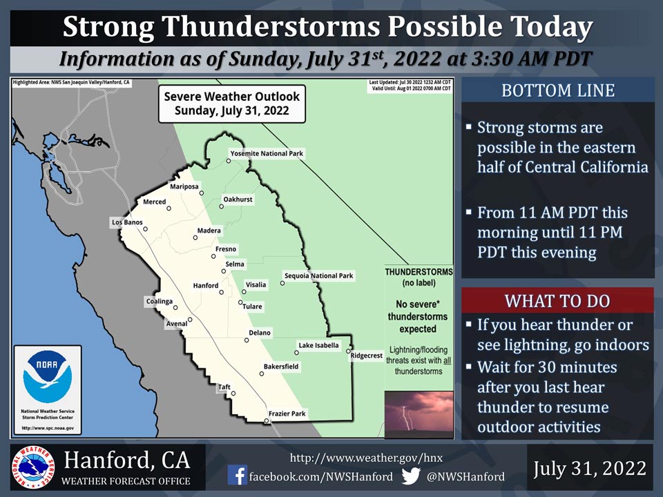
Includes Eastern Madera and Mariposa Counties and Yosemite National Park
July 31, 2022 - The National Weather Service Hanford Office reports a significant amount of monsoonal moisture will move into Central California today, leading to the possibility of strong thunderstorms in the green, shaded area.
Heavy rainfall in the Tulare and Fresno County portions of the Sierra Nevada could result in flash flooding.
Area Forecast Discussion
National Weather Service Hanford CA
315 AM PDT Sun Jul 31 2022
.SYNOPSIS...
Monsoonal moisture will increase today resulting in increased
shower and thunderstorm chances. Most activity will occur over
the mountains and desert but storms could move into the south
and east portions of the San Joaquin Valley this afternoon and
evening. Chances continue for the mountains and desert Monday
then just along the Sierra Tuesday through the end of the week.
Otherwise, temperatures will generally remain near to slightly
above climatological averages.
&&
.DISCUSSION...
High pressure aloft over the northern Great Basin continues to
spread a moist easterly flow over central California. Scattered
showers and isolated thunderstorms developed over the Sierra on
Saturday afternoon with radar still detecting some weak returns
overnight. A surge of additional monsoon moisture will move in
today for an increased chance of showers and thunderstorms. The
best chances will remain over the mountains and desert but some
activity may move into the foothills and San Joaquin Valley as
the steering flow veers more southeasterly this afternoon. Latest
HREF has precipitable water values around 1.6" and a slow storm
motion could result in locally heavy rainfall. Blended guidance
focuses the highest QPF over Fresno and Tulare County portions of
the Sierra Nevada. A Flash Flood Watch is in effect for this area
from late this morning through this evening. Moisture will remain
abundant on Monday but precipitation chances are trimmed back to
mainly the mountains and desert as the steering flow turns more
southerly. Chances are then confined to the Sierra from Tuesday
through the end of the week as flow aloft turns more southwest.
Widespread triple digit heat was observed across the San Joaquin
Valley again on Saturday. That makes 20 consecutive days with a
high of 100 degrees or more at both Fresno and Bakersfield. But
that streak may come to an end today for one or both locations.
The forecast high for Bakersfield today is 99 and for Fresno is
100. Scattered clouds and possible precipitation could make the
difference. Both locations are forecast to stay just below the
century mark on Monday and Tuesday then nudge a bit higher later
in the week. Overall, temperatures will hover near to slightly
above climatological averages throughout the upcoming week.
&&
.AVIATION...
VFR conditions will prevail across the San Joaquin Valley for
the next 24 hours. IFR or lower conditions expected in and near
thunderstorms across the Sierra Nevada, adjacent foothills, and
Kern County mountains and desert after 18Z through 06Z Monday.
&&
.AIR QUALITY ISSUES...
On Sunday July 31 2022...Unhealthy for Sensitive Groups in Tulare
County...and Sequoia National Park and Forest.
Source: NWS


