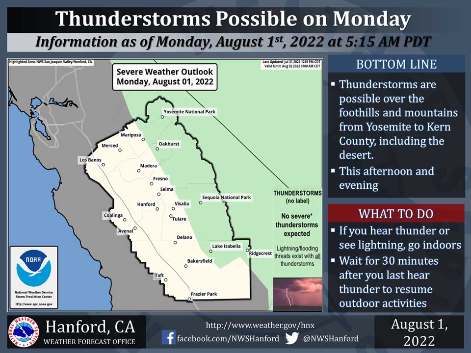
Includes Eastern Madera and Mariposa Counties and Yosemite National Park
August 1, 2022 - The National Weather Service Hanford Office reports a significant amount of monsoonal moisture will continue to move into Central California today, leading to the possibility of thunderstorms in the green, shaded area.
A chance of possible heavy rainfall will remain a possibility as moisture continue to stream into the region.In addition, any thunderstorm can produce dangerous cloud to ground lightning strikes.
Area Forecast Discussion
National Weather Service Hanford CA
323 AM PDT Mon Aug 1 2022
.SYNOPSIS...Monsoonal moisture will continue to push into the
area resulting in shower and thunderstorm chances over the Sierra
Nevada each afternoon and early evening this week. Temperatures
will remain near to slightly above climatological averages.
&&
.DISCUSSION...
Sunday saw more thunderstorm development over the Sierra Nevada
with some locally heavy rain over the higher elevations. Activity
has diminished to scattered light showers overnight, mainly over
Kern County. Monsoon moisture continues to spread in from the
south and east due to clockwise flow around the upper high over
the Great Basin. The flow aloft will turn more southerly today
and even a little southwest which will keep convection confined
to the mountains and desert areas. Precipitable water is around
1.5" per HREF, down slightly from yesterday. Locally heavy rain
is possible over the Sierra again today though storm motion looks
to be a little faster which would reduce the threat of flooding.
Model ensemble means agree with the upper high remaining over the
Four Corners region the rest of the week and into the weekend as
an upper low meanders offshore of northern California. This will
funnel a moist southerly flow over central California and maintain
a chance of showers and thunderstorms each afternoon. The focus
for convection will remain over the Sierra Nevada but a southeast
push could spread some activity down into the foothills or even
the eastern side of the San Joaquin Valley.
Much of the San Joaquin Valley topped out in the triple digits on
Sunday. Fresno and Bakersfield both had a high temperatures of
102 degrees, making 21 straight days of triple digit highs. That
streak may come to an end today but no guarantee as the forecast
high in Fresno is 99 degrees and Bakersfield is 100 degrees. The
forecast doesn't change much the rest of the week with highs for
Fresno and Bakersfield generally from 100 to 103 degrees, which is
slightly above climatological averages for early August.
&&
.AVIATION...Areas of mountain obscuring IFR conditions in and near
thunderstorms across the Sierra Nevada, adjacent foothills, and
Kern County mountains from 19Z through 06Z Tuesday. Otherwise, VFR
conditions will prevail elsewhere across central CA for the next
24 hours.
&&
.AIR QUALITY ISSUES...
None.
Source: NWS


