


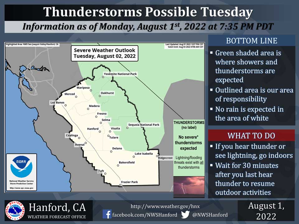
Includes Eastern Madera and Mariposa Counties and Yosemite National Park
August 2, 2022 - The National Weather Service Hanford Office reports a significant amount of monsoonal moisture will continue to move into Central California, leading to the possibility of thunderstorms in the green, shaded area.A chance of possible heavy rainfall will remain a possibility as moisture continue to stream into the region.
In addition, any thunderstorm can produce dangerous cloud to ground lightning strikes.
Area Forecast Discussion
National Weather Service Hanford CA
354 AM PDT Tue Aug 2 2022
.SYNOPSIS...Monsoonal moisture will continue to push into the
area resulting in shower and thunderstorm chances over the Sierra
Nevada each afternoon and early evening. Temperatures will remain
near to slightly above climatological averages.
&&
.DISCUSSION...
The synoptic pattern remains dominated by a high pressure ridge
centered over the Four Corners region and an upper low spinning
offshore northern California. Also noteworthy is Tropical Storm
Frank located west of the southern tip of Baja California, around
24N/124W. Satellite loops show some high clouds associated with
Frank spreading over central CA. Latest NHC guidance has Frank
tracking northwest today and weakening into a tropical depression
tonight. The remnants then move northward through the end of the
week with the deeper moisture remaining offshore. Little changes
are expected over the central California interior for the next
several days as monsoonal moisture will continue to be funneled
up from the south due to clockwise flow around the Four Corners
high and counterclockwise flow around the offshore upper low. A
chance of showers and thunderstorms remains over the Sierra each
day through the weekend. Convection is expected to mainly stay
along the Sierra Nevada crest north of Lake Isabella, but could
reach as far south as Tehachapi and Edwards AFB. In addition to
dangerous lightning, storms could produce locally heavy rainfall,
small hail, as well as strong and erratic outflow winds.
The high temperature at Fresno on Monday was 98 degrees; ending
the 21 day streak of triple digit highs. But the streak continues
for Bakersfield as the high on Monday was 101 degrees. Forecast
highs have the streak continuing through the weekend with highs
from 100 to 103 degrees. Some slight cooling is expected early
next week with forecast highs into the upper 90s, right around
climatological averages for early August.
&&
.AVIATION...Areas of mountain obscuring IFR conditions in and near
thunderstorms across the Sierra Nevada from 18Z until 04Z Wednesday.
Otherwise, VFR conditions will prevail elsewhere across central CA
for the next 24 hours.
&&
.AIR QUALITY ISSUES...
None.
Source: NWS
