


Click here for: Siskiyou County McKinney Fire Updates for Friday, August 5, 2022
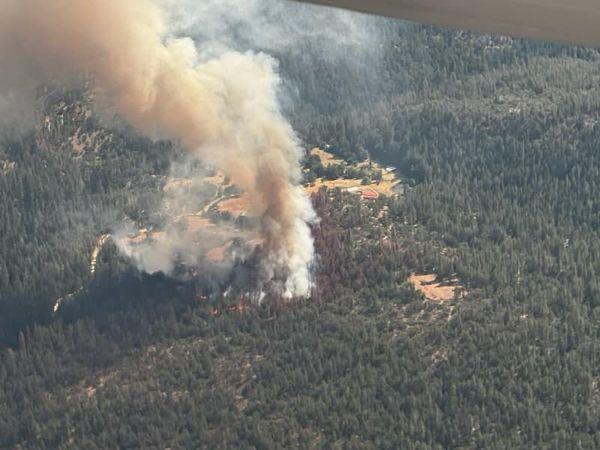
McKinney Fire in Siskiyou County on Friday, July 29, 2022
Credit: InciWeb
Click here for: Siskiyou County McKinney Fire Updates for Friday, August 5, 2022
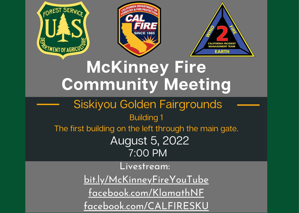
Update: McKinney Community meeting Friday, August 5, 2022, at 7:00 P.M.
A community meeting is being held for the McKinney Fire at 7:00 P.M. at the Siskiyou Golden Fairgrounds. The meeting is in building 1, the first building on the left as you pass through the main gate.
Address: 1712 Fairlane Road, Yreka, CA 96097
Questions can be sent ahead of time at 2022.McKinney@firenet.gov.
If you can’t join us in person, we are offering livestream on the following platforms:
Evening Update: Per Inciweb: McKinney Fire is now at 58,668 Acres, 10% Containment, with Personnel 2,404.
Basic Information
|
Current as of |
8/4/2022, 7:58:38 PM |
|
Incident Type |
Wildfire |
|
Date of Origin |
Friday July 29th, 2022, approx. 02:15 PM |
|
Location |
Siskiyou County, CA |
|
Incident Commander |
Unified Command - US Forest Service & CAL FIRE |
|
Incident Description |
Wildland Fire |
|
Coordinates |
41.819 latitude, -122.885 longitude |
Current Situation
|
Total Personnel |
2,404 |
|
Size |
58,668 Acres |
|
Percent of Perimeter Contained |
10% |
|
Fuels Involved |
Timber (Litter and Understory) Tall Grass (2.5 feet) Brush (2 feet) |
|
Significant Events |
Active Flanking Backing Creeping |
Outlook
|
Projected Incident Activity |
12 hours: Perimeter control focus as fire behavior has moderated allowing direct tactics as well as continuing indirect opportunities and contingency lines. Point protection of values at risk operations continue along the Highway 96 corridor near Walker Bridge, Horse Creek and Scott Bar. Fire has progressed to Collins Badly lookout in the south and is backing towards Scott Bar, and Humbug drainage, Deadwood Baldy Peak on the east flank. 24 hours: Direct and indirect line construction in all Branches as weather has moderated fire behavior. Fire continues to slowly spread along Klamath river corridor. Flanking, slope runs, and backing being forecasted for active fire behavior. |
Current Weather
|
Weather Concerns |
THURSDAY: HOTTER AND DRIER. BREEZY WEST WINDS AFTER NOON. WEATHER: Mostly sunny. Hotter and drier. WIND (EYE LEVEL): Sheltered and smoked in areas: Downslope/down valley 1-3 mph through 1400 then variable 2-4 mph. Ridges, unsheltered areas, wind-aligned drainages: East 3-6 mph through 1200 then west-northwest 6-12 mph with gusts to 18 mph. CHANCE OF WETTING RAIN: 0%. RAIN AMOUNTS: none. MAX TEMPERATURES: 93-98 bottom and clear areas, 82-87 top and smoked in areas. MIN RH: 13-18% bottom and clear areas, 18-23% top, 23-30% smoked in areas. INVERSION: Moderate mid-slope inversion and secondary inversion mixes out by 1500. Smoke inversion unlikely to mix out in smoked in areas. Extended outlook: Friday through Sunday: Mostly sunny, hot, dry, and breezy. Highs 95-105. Minimum humidity: 10-20%. Diurnal winds west-northwest 5-15 mph with gusts to 20 mph. |
Update: 9:00 A.M.
Location: Siskiyou County, CA
Size: 58,668 acres
Cause: Under Investigation
Start Date: Friday July 29, 2022 at 2:15pm
Percent Contained: 10%
Vegetation: Timber (Litter and Understory), Tall Grass, and Brush
Number of Personnel Assigned: 2,219
Tuesday’s thunderstorms dropped 1-3 inches of rain on the eastern flank of the McKinney Fire. The higher amounts fell on the eastern one third. Heavy debris flow occurred as a result in multiple drainages and blocked lower lying portions of Humbug Creek Rd. On Wednesday morning, heavy equipment was used to reestablish access into the area for the firefighters working that branch of the fire. Although a considerable amount of rain fell, many pockets of heat remain. As the area dries in the coming days, fire activity in the east is expected to pick up once again. The western half of the fire did not receive measurable precipitation.
Yesterday morning fire behavior was minimal over the entire incident with very little active burning. Pockets of heavy fuels continued to smoke throughout the morning and fire activity picked up on the western portion of the incident as fuels, heated by the afternoon sun, began to dry out. The fire was most active near Mill Creek Road in the southwest portion and Pipeline Gap in the northwest. Pipeline Gap is an area with high potential for fire spread. Helicopters and air tankers were used to support firefighters on the ground as they fought to limit spread in both areas. Aircraft dropped over 50,000 gallons of retardant during the operational period.
Progress in fireline construction has been steady but slow going along the fire’s edge. Difficult terrain and heavy fuels have been a challenge. However, dozer lines have been completed in multiple areas surrounding the fire. The fire is holding along the river’s edge east of Horse Creek along Highway 96.
An increase in fire behavior due to weather changing over the next several days will add to the challenge. Firefighters will keep a close eye on conditions today as they continue direct line construction wherever it is safe to do so. They will also evaluate options near Pipeline Gap, Bald Mountain and Baldy Gap where direct line construction may not be an option.
COMMUNITY MEETING:
A community meeting is being planned for tomorrow night in Yreka at the Siskiyou Golden Fairgrounds. Details on the time and specific meeting location will be announced shortly.
Questions desired to be answered are appreciated in advance and can be sent to 2022.mckinney@firenet.gov
WEATHER:
The fire area will be warmer and drier today. Humidity on peak and ridges started out lower today and winds will primarily out of the west this afternoon.
EVACUATIONS:
Multiple Evacuation orders and warnings remain in effect. For current updates on evacuations, visit https://www.facebook.com/SiskiyouCountySheriff and https://www.facebook.com/SiskiyouCountyOES
Additional evacuation information and a map can be found on the Zonehaven site at: https://community.zonehaven.com/
A shelter has been established at the Weed Community Center, 161 E Lincoln Avenue, Weed, CA 96094. Highway 96 remains closed through the fire area.
CURRENT FOREST ORDERS:
Fire restrictions are in effect on the Klamath National Forest. For more information, visit
https://www.fs.usda.gov/alerts/klamath/alerts-notices/
Pacific Crest Trail Information: https://www.pcta.org/discover-the-trail/closures
Note: Evacuation Orders for the following Zones in the Yreka and Hawkinsville area have been downgraded to Evacuation Warning. Residents may return to their homes. This area primarily encompasses the area of Yreka from Fairchild Street/Shasta Ave west to edge of the residential district, this involves the following Zones:
Yreka Zones:
• YRE – 3624-A
• YRE – 3624-B
• YRE – 3621-B
• YRE – 3621-C
• YRE – 3618-D
• YRE – 3615-B
• YRE – 3612-A
Siskiyou Zones:
• SIS – 3404-A
• SIS – 3508-A
• SIS – 3609-B
To access the evacuation areas map and road closures, go to Zone Haven: community.zonehaven.com or to the Siskiyou County OES website: https://www.co.siskiyou.ca.us/emergencyservices Safety is our first priority for our community. The Zones that have been downgraded and residents allowed to return home are because it is now deemed safe to do so by law enforcement, fire, and emergency services. All other Zones outside of the Yreka and Hawkinsville area and not listed here remain as Evacuation Order. Evacuation Zones are reviewed daily to determine safety to repopulate.
Getting home:
• Use caution on the roadways. Congestion from fire and responder personnel in these areas.
• Bus transportation is being arranged through STAGE for residents in the shelter who require transportation home.
• Animals: Please pickup your animals from the animal shelter. For shelter residents returning home by bus, Animal Control representatives will collect your information and your pet’s information and arrange for delivery of your animals.
- For animal related questions or assistance please call our animal welfare hotline at 530-842-8742.
Crisis Counseling Services: Disasters are stressful. Crisis counseling services are available through Siskiyou County Behavioral Health. Call the Access Crisis Line to speak to a local counselor: 800-842-8979. The National Disaster Distress Helpline is also available for anyone experiencing emotional distress related to disasters such as wildfires, earthquakes, or incident of mass violence. The National Disaster Distress Helpline can be accessed 24 hours a day, 7 days a week at:
• Call 1-800-985-5990 or text TalkWithUs to 66746 to connect with a trained crisis counselor.
www.samhsa.gov/find-help/disaster-distress-helpline
For general information call 2-1-1 or follow Siskiyou County OES on Facebook.
Update 6:00 A.M. McKinney Fire in Siskiyou County Public Information and Infrared Maps for Thursday, August 4, 2022
Update 6:00 A.M. Caltrans Road ConditionsUpdate 6:00 A.M. Air Quality Measurements
August 4, 2022 - McKinney Fire in Siskiyou County acreage for Thursday morning: 57,519.
Basic Information
| Current as of | 8/4/2022, 7:52:48 AM |
| Incident Type | Wildfire |
| Date of Origin | Friday July 29th, 2022 approx. 02:15 PM |
| Location | Siskiyou County, CA |
| Incident Commander | Unified Command - US Forest Service & CAL FIRE |
| Incident Description | Wildland Fire |
| Coordinates | 41.819 latitude, -122.885 longitude |
Current Situation
| Total Personnel | 2,219 |
| Size | 57,519 Acres |
| Percent of Perimeter Contained | 10% |
| Fuels Involved |
Timber (Litter and Understory) Tall Grass (2.5 feet) Brush (2 feet) |
| Significant Events |
Active Flanking Backing Creeping |
Outlook
| Projected Incident Activity |
12 hours: Perimeter control focus as fire behavior has moderated allowing direct tactics as well as continuing indirect opportunities and contingency lines. Point protection of values at risk operations continue along the Highway 96 corridor near Walker Bridge, Horse Creek and Scott Bar. Fire has progressed to Collins Badly lookout in the south and is backing towards Scott Bar, and Humbug drainage, Deadwood Baldy Peak on the east flank. 24 hours: Direct and indirect line construction in all Branches as weather has moderated fire behavior. Fire continues to slowly spread along Klamath river corridor. Flanking, slope runs, and backing being forecasted for active fire behavior. |
Current Weather
| Weather Concerns |
THURSDAY: HOTTER AND DRIER. BREEZY WEST WINDS AFTER NOON. WEATHER: Mostly sunny. Hotter and drier. WIND (EYE LEVEL): Sheltered and smoked in areas: Downslope/down valley 1-3 mph through 1400 then variable 2-4 mph. Ridges, unsheltered areas, wind-aligned drainages: East 3-6 mph through 1200 then west-northwest 6-12 mph with gusts to 18 mph. CHANCE OF WETTING RAIN: 0%. RAIN AMOUNTS: none. MAX TEMPERATURES: 93-98 bottom and clear areas, 82-87 top and smoked in areas. MIN RH: 13-18% bottom and clear areas, 18-23% top, 23-30% smoked in areas. INVERSION: Moderate mid-slope inversion and secondary inversion mixes out by 1500. Smoke inversion unlikely to mix out in smoked in areas. Extended outlook: Friday through Sunday: Mostly sunny, hot, dry, and breezy. Highs 95-105. Minimum humidity: 10-20%. Diurnal winds west-northwest 5-15 mph with gusts to 20 mph. |
Click here for: Siskiyou County McKinney Fire Updates for Wednesday, August 3, 2022
