


Click here for: Siskiyou County McKinney Fire Updates for Thursday, August 4, 2022
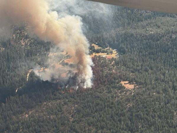
McKinney Fire in Siskiyou County on Friday, July 29, 2022
Credit: InciWeb
Click here for: Siskiyou County McKinney Fire Updates for Thursday, August 4, 2022
Evening Update: 6:25 P.M. Inciweb: McKinney Fire is now at 57,519 Acres, 10% Containment, with Personnel 2,219.
Basic Information
|
Current as of |
8/3/2022, 6:24:50 PM |
|
Incident Type |
Wildfire |
|
Date of Origin |
Friday July 29th, 2022, approx. 02:15 PM |
|
Location |
Siskiyou County, CA |
|
Incident Commander |
Unified Command - US Forest Service & CAL FIRE |
|
Incident Description |
Wildland Fire |
|
Coordinates |
41.819 latitude, -122.885 longitude |
Current Situation
|
Total Personnel |
2,219 |
|
Size |
57,519 Acres |
|
Percent of Perimeter Contained |
10% |
|
Fuels Involved |
Timber (Litter and Understory) Tall Grass (2.5 feet) Brush (2 feet) |
|
Significant Events |
Active Flanking Backing |
Outlook
|
Planned Actions |
Implement direct/indirect line as resources take advantage of fire behavior. Perimeter control direct line has been effective in minimizing acreage burned. Point protection and mop-up around values at risk along Walker Bridge and other communities along Hwy 96. from Hwy 263 junction to Seiad, east towards Yrek , Scott Bar, and Horse Creek on the west. Assist Klamath NF with new lightning ignitions as requested, with CAL FIRE. |
|
Projected Incident Activity |
12 hours: Perimeter control focus as fire behavior has moderated allowing direct tactics as well as continuing indirect opportunities and contingency lines. Point protection of values at risk operations continue along the Highway 96 corridor near Walker Bridge, Horse Creek and Scott Bar. Fire has progressed to Collins Badly lookout in the south and is backing towards Scott Bar, and Humbug drainage, Deadwood Baldy Peak on the east flank. Area under Red Flag Watch into Tuesday for lightning over the fire area. 24 hours: Direct and indirect line construction in all Branches as weather has moderated fire behavior. Fire continues to slowly spread along Klamath river corridor. Flanking, slope runs, and backing being forecasted for fire behavior. |
Current Weather
|
Weather Concerns |
WEDNESDAY: AFTERNOON THUNDERSTORMS POSSIBLE. WEATHER: Partly sunny with a slight chance of showers and thunderstorms in the afternoon. WIND (EYE LEVEL): Sheltered and smoked in areas: Downslope/down valley 1-3 mph through 1400 then variable 2-4 mph. Ridges, unsheltered areas, wind-aligned drainages: East 3-6 mph through 1200 then west 6-12 mph with gusts to 18 mph. Gusty erratic outflow winds to 30 mph possible near any thunderstorms. CHANCE OF WETTING RAIN: 10%. RAIN AMOUNTS: 0.10-0.25 in storm cores. MAX TEMPERATURES: 90-95 bottom and clear areas, 80-85 top and smoked in areas. MIN RH: 15-20% bottom and clear areas, 20-30% top and smoked in areas. INVERSION: Weak mid-slope inversion mixes out by 1400. Stronger inversion in heavy smoke unlikely to mix out. WEDNESDAY NIGHT: POORER RECOVERIES. WEATHER: Mostly clear. WIND (20 FT): Sheltered areas: Downslope/down valley 2-4 mph. Ridges, unsheltered areas, wind-aligned drainages: West 5-10 mph through 2200 then variable 2-5 mph. CHANCE OF WETTING RAIN: 0%. RAIN AMOUNTS: none. MIN TEMPERATURES: 55-60 bottom, 60-65 top. MAX RH: 30-40%, 45-50% bottom. INVERSION: Moderate developing near mid-slope. Secondary inversion at 5,000 feet. THURSDAY: HOTTER AND DRIER. BREEZY WEST WINDS AFTER NOON. WEATHER: Mostly sunny. Hotter and drier. WIND (EYE LEVEL): Sheltered and smoked in areas: Downslope/down valley 1-3 mph through 1400 then variable 2-4 mph. Ridges, unsheltered areas, wind-aligned drainages: East 3-6 mph through 1200 then west-northwest 6-12 mph with gusts to 18 mph. CHANCE OF WETTING RAIN: 0%. RAIN AMOUNTS: none. MAX TEMPERATURES: 93-98 bottom and clear areas, 82-87 top and smoked in areas. MIN RH: 13-18% bottom and clear areas, 18-23% top, 23-30% smoked in areas. INVERSION: Moderate mid-slope inversion and secondary inversion mixes out by 1500. Smoke inversion unlikely to mix out in smoked in areas. Extended outlook: Friday through Sunday: Mostly sunny, hot, dry, and breezy. Highs 95-105. Minimum humidity: 10-20%. Diurnal winds west-northwest 5-15 mph with gusts to 20 mph. |
Update 9:40 A.M. Siskiyou County McKinney Fire Operational Video Update for Wednesday, August 3, 2022
Update 6:00 A.M. McKinney Fire in Siskiyou County Public Information and Briefing Maps for Wednesday, August 3, 2022Update 6:00 A.M. Caltrans Road Conditions
Update 6:00 A.M. Air Quality Measurements
August 3, 2022 - McKinney Fire in Siskiyou County acreage for Wednesday morning: 57,515.
Updated 9:55 A.M.
Location: Siskiyou County, CA
Size: 57,515
Cause: Under Investigation
Start Date: Friday July 29, 2022 at 2:15pm
Percent Contained: 0%
Vegetation: Timber (Litter and Understory), Tall Grass, and Brush
Number of Personnel Assigned: 1,885
With drier and hotter weather in the forecast, increased fire activity is anticipated over the next few days. Yesterday's showers kept the fire from gaining significant growth. This allowed firefighters to move to an offensive approach where they can now focus on opportunities to go both direct and indirect on the fire. With the rainfall also comes hazardous debris, such as mud, downed trees, and rockfall; ultimately causing fire personnel to work more cautiously in these areas of the fire.
The one to three inches of rainfall last night over the eastern portion of the fire helped firefighters to gain ground on tying in handline throughout night operations. Crews are making good progress on the 200–300-acre spot fire from a few days ago on the northern edge of the fire.
Additional fireline has been constructed from Humbug Ridge to Baldy Gap aiding in securing the fire’s edge. The fire has progressed to Collins Baldy Lookout in the south and is backing towards Scott Bar and the Humbug Creek Drainage, where the fuel load is heavy with dead and down trees. Hand crews were able to cut handline along Scott Bar to get access on the western edge of the fire.
COMMUNITY MEETING:
A community meeting is scheduled for tonight, August 3, at the Scott Valley Junior High School starting at 7:00 p.m. The address is 237 Butte Street, Fort Jones, CA, 96032.
The meeting will also be livestreamed on https://bit.ly/McKinneyFireYouTube and the CAL FIRE Siskiyou Unit Facebook https://www.facebook.com/CALFIRESKU for those not able to attend in person.
Questions desired to be answered are appreciated in advance and can be sent to 2022.mckinney@firenet.gov
WEATHER:
Temperatures are forecasted in the low 90’s with low relative humidity and chances of thunderstorms in the afternoon just east of the fire. Gusty west winds are possible, ranging from 15-20 miles per hour in drainage areas.
EVACUATIONS:
Multiple Evacuation orders and warnings remain in effect. For current updates on evacuations, visit https://www.facebook.com/SiskiyouCountySheriff and https://www.facebook.com/SiskiyouCountyOES
Additional evacuation information and a map can be found on the Zonehaven site at: https://community.zonehaven.com/
A shelter has been established at the Weed Community Center, 161 E Lincoln Avenue, Weed, CA 96094. Highway 96 remains closed through the fire area.
CURRENT FOREST ORDERS :
Fire restrictions are in effect on the Klamath National Forest. For more information, visit
https://www.fs.usda.gov/alerts/klamath/alerts-notices/
Pacific Crest Trail Information: https://www.pcta.org/discover-the-trail/closures
Basic Information
| Current as of | 8/3/2022, 7:41:53 AM |
| Incident Type | Wildfire |
| Date of Origin | Friday July 29th, 2022 approx. 02:15 PM |
| Location | Siskiyou County, CA |
| Incident Commander | Unified Command - US Forest Service & CAL FIRE |
| Incident Description | Wildland Fire |
| Coordinates | 41.819 latitude, -122.885 longitude |
Current Situation
| Total Personnel | 1,885 |
| Size | 57,519 Acres |
| Fuels Involved |
Timber (Litter and Understory) Tall Grass (2.5 feet) Brush (2 feet) |
| Significant Events |
Active Flanking Backing |
Outlook
| Planned Actions |
Implement direct/indirect line as resources take advantage of active fire behavior. Perimeter control direct line has been effective in minimizing acreage burned. Point protection and mop-up around values at risk along Walker Bridge and other communities along Hwy 96. from Hwy 263 junction to Seiad, east towards Yreka, Scott Bar, and Horse Creek on the west. Assist Klamath NF with new lightning ignitions as requested. |
| Projected Incident Activity |
12 hours: Perimeter control focus as fire behavior has moderated allowing direct tactics as well as continuing indirect opportunities and contingency lines. Point protection of values at risk operations continue along the Highway 96 corridor near Walker Bridge, Horse Creek and Scott Bar. Fire has progressed to Collins Badly lookout in the south and is backing towards Scott Bar, and Humbug drainage, Deadwood Baldy Peak on the east flank. Area under Red Flag Watch into Tuesday for lightning over the fire area. 24 hours: Direct and indirect line construction in all Branches as weather has moderated fire behavior. Fire continues to slowly spread along Klamath river corridor. Flanking, slope runs, and backing being forecasted for fire behavior. |
Current Weather
| Weather Concerns |
WEDNESDAY: RED FLAG WARNING WEATHER: Widespread haze. Sunny and hot, with a high near 96. Calm wind becoming west 5 to 7 mph in the afternoon. Scattered thunderstorms with lightning, heavy rain, hail and gusty winds developed this afternoon and evening across Siskiyou County with isolated to scattered storms over Klamath National Forest. Thunderstorms will be capable of producing gusty winds to 50 mph, small hail, abundant lightning, and very heavy rainfall. Periods of heavy rainfall may create flash flooding, debris flows, and rock falls over area wildfires and recent burn scars in steep terrain. Temperatures will be increasing this weekend and will be hot once again with warm overnight lows. Smoke may create periods of degraded air quality. Tonight: Widespread haze after 11pm. Patchy smoke before 11pm. Mostly clear, with a low around 64. West northwest wind 8 to 13 mph becoming light northwest in the evening. Winds could gust as high as 20 mph. |
Click here for: Siskiyou County McKinney Fire and China 2 Fire Updates for Tuesday, August 2, 2022
