


Click here for: Siskiyou County McKinney Fire Updates for Wednesday, August 3, 2022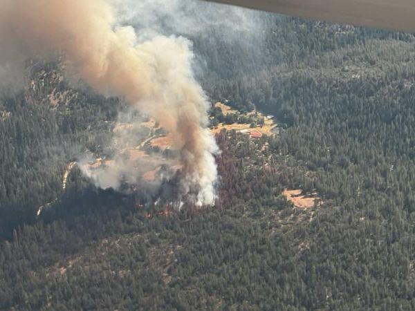
McKinney Fire in Siskiyou County on Friday, July 29, 2022
Credit: InciWeb
Click here for: Siskiyou County McKinney Fire Updates for Wednesday, August 3, 2022
Evening Update 7:10 P.M. Inciweb: 56,459 Acres, Personnel 1,885.
Basic Information
|
Current as of |
8/2/2022, 7:10:36 PM |
|
Incident Type |
Wildfire |
|
Date of Origin |
Friday July 29th, 2022 approx. 02:15 PM |
|
Location |
Siskiyou County, CA |
|
Incident Commander |
Unified Command - US Forest Service & CAL FIRE |
|
Incident Description |
Wildland Fire |
|
Coordinates |
41.819 latitude, -122.885 longitude |
Current Situation
|
Total Personnel |
1,885 |
|
Size |
56,459 Acres |
|
Fuels Involved |
Timber (Litter and Understory) Tall Grass (2.5 feet) Brush (2 feet) |
|
Significant Events |
Active Flanking Backing Group Torching |
Outlook
|
Planned Actions |
Implement direct/indirect line as resources take advantage of active fire behavior. Perimeter control direct line has been effective in minimizing acreage burned. Point protection and mop-up around values at risk along Walker Bridge and other communities along Hwy 96. from Hwy 263 junction to Seiad, east towards Yreka, Scott Bar, and Horse Creek on the west. Assist Klamath NF with new lightning ignitions as requested. |
|
Projected Incident Activity |
12 hours: Perimeter control focus as fire behavior has moderated allowing direct tactics as well as continuing indirect opportunities and contingency lines. Point protection of values at risk operations continue along the Highway 96 corridor near Walker Bridge, Horse Creek and Scott Bar. Fire has progressed to Collins Badly lookout in the south and is backing towards Scott Bar, and Humbug drainage, Deadwood Baldy Peak on the east flank. Area under Red Flag Watch into Tuesday for lightning over the fire area. 24 hours: Direct and indirect line construction in all Branches as weather has moderated fire behavior. Fire continues to slowly spread along Klamath river corridor. Flanking, slope runs, and backing being forecasted for fire behavior. 48 hours: Active fire behavior will continue to be influenced by the normal temperatures, lower relative humidity, and low wind speeds. Slope and terrain driven runs and diurnal Klamath River wind flows will also influence ROS as thunderstorm potential decreases. 72 hours: Flanking, slope runs, and backing being forecasted for fire behavior, current active fire behavior will continue to be influenced by the normal temperatures, lower relative humidity. |
Current Weather
|
Weather Concerns |
TUESDAY: RED FLAG WARNING WEATHER: Mostly cloudy. Isolated showers and thunderstorms through 1600, then scattered showers and thunderstorms. Some storms may produce heavy rain. WIND (EYE LEVEL): Sheltered and smoked in areas: Downslope/down valley 1-3 mph through 1400 then variable 2-4 mph. Ridges, unsheltered areas, wind-aligned drainages: East 3-6 mph through 1200 then west-southwest 5-10 mph with gusts to 15 mph. Erratic wind gusts up to 50 mph possible near any storms. CHANCE OF WETTING RAIN: 30%. RAIN AMOUNTS: 0.25-0.50 in storm cores. MAX TEMPERATURES: 85-90 bottom and clear areas, 75-80 top and smoked in areas. MIN RH: 45-55% bottom and clear areas, 55-65% top and smoked in areas. INVERSION: Weak mid-slope inversion mixes out by 1400. Stronger inversion in heavy smoke unlikely to mix out. TUESDAY NIGHT: RED FLAG WARNING UNTIL 2300 WEATHER: Mostly cloudy with scattered showers and thunderstorms mainly before 2300. Some storms may produce heavy rain. WIND (20 FT): Sheltered areas: Downslope/down valley 2-4 mph. Ridges, unsheltered areas, wind-aligned drainages: South-southeast 3-6 mph. Erratic wind gusts up to 50 mph possible near any storms. CHANCE OF WETTING RAIN: 30%. RAIN AMOUNTS: 0.25-0.50 in storm cores. MIN TEMPERATURES: 65-70 bottom, 60-65 top. MAX RH: 70-90% all areas. INVERSION: weak near mid-slope. |
Update 4:12 P.M. Inciweb: 56,165 Acres, Personnel 1,363.
Basic Information
|
Current as of |
8/2/2022, 4:11:39 PM |
|
Incident Type |
Wildfire |
|
Date of Origin |
Friday July 29th, 2022, approx. 02:15 PM |
|
Location |
Siskiyou County, CA |
|
Incident Commander |
Unified Command - US Forest Service & CAL FIRE |
|
Incident Description |
Wildland Fire |
|
Coordinates |
41.819 latitude, -122.885 longitude |
Current Situation
|
Total Personnel |
1,363 |
|
Size |
56,165 Acres |
|
Fuels Involved |
Timber (Litter and Understory) Tall Grass (2.5 feet) Brush (2 feet) |
|
Significant Events |
Moderate Flanking Backing Creeping |
Outlook
|
Planned Actions |
Implement direct/indirect line as resources take advantage of moderate fire behavior. Perimeter control direct line has been effective in minimizing acreage burned. Point protection and mop-up around values at risk along Walker Bridge and other communities along Hwy 96. Assist Klamath NF with new lightning ignitions as requested. |
|
Projected Incident Activity |
12 hours: Perimeter control focus as fire behavior has moderated allowing direct tactics as well as continuing indirect opportunities and contingency lines. Point protection of values at risk operations continue along the Highway 96 corridor near Walker Bridge, Horse Creek and Scott Bar. Fire has progressed to Collins Badly lookout in the south and is backing towards Scott Bar, and Humbug drainage, Deadwood Baldy Peak on the east flank. Area under Red Flag Watch into Tuesday for lightning over the fire area. 24 hours: Direct and indirect line construction in all Branches as weather has moderated fire behavior. Fire continues to slowly spread along Klamath river corridor. Flanking, slope runs, and backing being forecasted for fire behavior. 48 hours: Moderate fire behavior will continue to be influenced by the normal temperatures, higher relative humidity, and low wind speeds. Slope and terrain driven runs and diurnal Klamath River wind flows will also influence ROS as thunderstorm potential decreases. |
Current Weather
|
Weather Concerns |
Red Flag watch has been extended into Tuesday for lightning on dry fuels. Gusty outflow winds above 30 mph could be possible near thunderstorm cells. The precipitation that fell overnight on 7/31 was isolated with heavy rain is some areas to zero precipitation over other areas. Higher relative humidity and cooler temperatures moderated the fire behavior last two operational periods. |
Update 9:30 A.M. Siskiyou County McKinney Fire Operational Video Update for Tuesday, August 2, 2022
Update 6:00 A.M. Caltrans Road Conditions
Update 6:00 A.M. Air Quality Measurements
Update 6:00 A.M. McKinney Fire and China 2 Fire in Siskiyou County Public Information and Briefing Maps for Tuesday, August 2, 2022
August 2, 2022 - McKinney Fire in Siskiyou County acreage for Tuesday morning: 56,165 with 0% Containment
Update 11:00 A.M.
McKINNEY FIRE & YETI COMPLEX INCIDENT UPDATE
Date: 08/02/2022
Location: Siskiyou County, CA
Size: McKinney 56,165 ; Yeti Complex 2,430
Cause: Under Investigation
Start Date: Friday July 29, 2022 at 2:15pm
Percent Contained: McKinney 0% ; Yeti Complex 0%
Vegetation: Timber (Litter and Understory), Tall Grass, and Brush
Number of Personnel Assigned: McKinney: 1,363; Yeti Complex: 450
Summary:
Lower temperatures and higher relative humidity, including rain over some areas of the fire, moderated fire behavior allowed firefighters to make good progress on the fire yesterday. In the absence of the explosive fire behavior observed previously, firefighters were able to take a more direct posture and engage directly on the McKinney, China 2, and Alex fires.
On the McKinney Fire west of Yreka, direct line has been initiated along Humbug Ridge down to Baldy Gap. This area received significant rain Sunday night, and the wet fuels will allow line improvement to continue over the next few days. On the southeast portion of the fire, dozers are working east to open up access to the fireline from Scott Bar. This will allow crews and equipment to have better access to the fire. Crews are also working around structures in that area. Dozers are working the northwest corner while four hotshot crews build direct line on the northern edge.
The China 2 fire has burned up to dozer lines on China Peak as well as to Highway 96. Firefighters will continue to work those lines to hold the fire. Engine crews are prepping structures south of Highway 96.
There was no significant movement on the Alex Fire. Helicopters assisted hand crews on the ground with water drops.
Today firefighters will continue to look for areas on the fires where they can have direct attack opportunities as well as work to place contingency line in areas where direct attack is not possible. Life, firefighter safety, and property remain the most significant priority to the incident. The combination of moisture and thunderstorms in the forecast are creating an unstable atmosphere which may make firefighting conditions much more hazardous with wind speeds potentially reaching 50 mph during those storms.
California Interagency Incident Management Team 2 in unified command with CAL FIRE assumed command of the McKinney Fire at 6:00 a.m. this morning. California Interagency Incident Management Team 10 has assumed command of the China 2, Alex and surrounding lightning fires, now known as the Yeti Complex. Information for the Yeti Complex will continue to be posted on the Klamath NF, CALFIRE SKU sites, and will have its own Inciweb page set up for the incident.
WEATHER: The Red Flag Fire Warning for abundant lightning on dry fuels has been extended through Tuesday.
EVACUATIONS:
Multiple Evacuation orders and warnings remain in effect. For current updates on evacuations, visit https://www.facebook.com/SiskiyouCountySheriff and https://www.facebook.com/SiskiyouCountyOES Additional evacuation information and a map can be found on the Zonehaven site at: https://community.zonehaven.com/websiteA shelter has been established at the Weed Community Center, 161 E Lincoln Avenue, Weed, CA 96094. Highway 96 remains closed through the fire area.
FOREST CLOSURE: Fire restrictions are in effect on the Klamath National Forest. For more information, visit https://www.fs.usda.gov/alerts/klamath/alerts-notices/
Pacific Crest Trail Information: https://www.pcta.org/discover-the-trail/closures/
Basic Information as of 9:33 A.M.
| Current as of | 8/2/2022, 9:33:30 AM |
| Incident Type | Wildfire |
| Date of Origin | Friday July 29th, 2022 approx. 02:15 PM |
| Location | Siskiyou County, CA |
| Incident Commander | Unified Command - US Forest Service & CAL FIRE |
| Incident Description | Wildland Fire |
| Coordinates | 41.819 latitude, -122.885 longitude |
Current Situation
| Total Personnel | 1,363 |
| Size | 56,165 Acres |
| Fuels Involved |
Timber (Litter and Understory) Tall Grass (2.5 feet) Brush (2 feet) |
| Significant Events |
Active Flanking Short-range Spotting Backing |
Outlook
| Planned Actions |
Implement direct/indirect line as resources take advantage of moderated fire behavior and be effective. Point protection of values at risk along Walker Bridge. Contingency planning for areas further west and east as perimeter continues to spread. Assist Klamath NF with new lightning ignitions. |
| Projected Incident Activity |
12 hours: Perimeter control focus as fire behavior has moderated allowing direct tactics as well as continuing indirect opportunities. Point protection of values at risk operations continue along the Highway 96 corridor near Walker Bridge, Horse Creek and Scott Bar. Fire has progressed to Collins Badly lookout in the south and is backing towards Scott Bar, and Humbug drainage, Deadwood Baldy Peak on the east flank. Fire will continue to move west towards Horse Creek and north into the 2014 Beaver Fire scar towards Round Mountain. Area under Red Flag Watch into Tuesday for lightning over the fire area. 24 hours: Point protection operations continue along the Highway 96 corridor, Walker Bridge community. Direct and indirect line construction in all Branches as weather has moderated fire behavior. Fire continues to spread along Klamath river corridor. Flanking, slope runs and low fuel moistures forecasted fire behavior. 48 hours: Thunderstorm development has lessened as ridge moves into place. Fire behavior will continue to be influenced by the above normal temperatures, poor relative humidity, critical 100 and 1000 hr fuel moisture. Slope and terrain driven runs and diurnal Klamath River wind flows will also influence ROS as thunderstorm potential decreases. |
Current Weather
| Weather Concerns |
Red Flag watch has been extended into Tuesday for lightning on dry fuels. Gusty outflow winds of 30 to 50 mph could be possible near thunderstorm cells. LAL of 3. ERC above the 97th percentile and probability of ignition of 90%. The precipitation that fell overnight was isolated with heavy rain is some areas to zero precipitation over other areas. Higher relative humidity a |
Basic Information as of 8:37 A.M.
| Current as of | 8/2/2022, 8:37:06 AM |
| Incident Type | Wildfire |
| Date of Origin | Friday July 29th, 2022 approx. 02:15 PM |
| Location | Siskiyou County, CA |
| Incident Commander | Unified Command - US Forest Service & CAL FIRE |
| Incident Description | Wildland Fire |
| Coordinates | 41.819 latitude, -122.885 longitude |
Current Situation
| Total Personnel | 1,363 |
| Size | 55,493 Acres |
| Fuels Involved |
Timber (Litter and Understory) Tall Grass (2.5 feet) Brush (2 feet) |
| Significant Events |
Active Flanking Short-range Spotting Backing |
Outlook
| Planned Actions |
Implement direct/indirect line as resources take advantage of moderated fire behavior and be effective. Point protection of values at risk along Walker Bridge. Contingency planning for areas further west and east as perimeter continues to spread. Assist Klamath NF with new lightning ignitions. |
| Projected Incident Activity |
12 hours: Perimeter control focus as fire behavior has moderated allowing direct tactics as well as continuing indirect opportunities. Point protection of values at risk operations continue along the Highway 96 corridor near Walker Bridge, Horse Creek and Scott Bar. Fire has progressed to Collins Badly lookout in the south and is backing towards Scott Bar, and Humbug drainage, Deadwood Baldy Peak on the east flank. Fire will continue to move west towards Horse Creek and north into the 2014 Beaver Fire scar towards Round Mountain. Area under Red Flag Watch into Tuesday for lightning over the fire area. 24 hours: Point protection operations continue along the Highway 96 corridor, Walker Bridge community. Direct and indirect line construction in all Branches as weather has moderated fire behavior. Fire continues to spread along Klamath river corridor. Flanking, slope runs and low fuel moistures forecasted fire behavior. 48 hours: Thunderstorm development has lessened as ridge moves into place. Fire behavior will continue to be influenced by the above normal temperatures, poor relative humidity, critical 100 and 1000 hr fuel moisture. Slope and terrain driven runs and diurnal Klamath River wind flows will also influence ROS as thunderstorm potential decreases. |
Current Weather
| Weather Concerns |
Red Flag watch has been extended into Tuesday for lightning on dry fuels. Gusty outflow winds of 30 to 50 mph could be possible near thunderstorm cells. LAL of 3. ERC above the 97th percentile and probability of ignition of 90%. The precipitation that fell overnight was isolated with heavy rain is some areas to zero precipitation over other areas. Higher relative humidity and cooler temperatures moderated the fire behavior today. |
Click here for: Siskiyou County McKinney Fire and China 2 Fire Updates for Monday, August 1, 2022
