


Click here for: Siskiyou County McKinney Fire and China 2 Fire Updates for Tuesday, August 2, 2022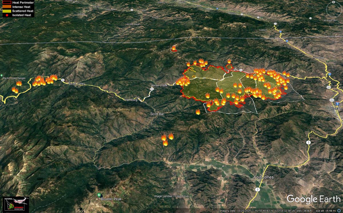
Google Earth Map of the McKinney and China 2 Fire Perimeter on Monday morning
Click here for: Siskiyou County McKinney Fire and China 2 Fire Updates for Tuesday, August 2, 2022
Evening Update: Fire is now at 55,493 Acres, with 1,363 total Personnel.
Fire activity was again mitigated today by cloudy, cooler conditions. On the McKinney Fire, no perimeter growth was observed. Crews were able to work successfully behind the city of Yreka, bringing dozer line along the ridge to protect the structures. In the steep area on the fire’s southern edge, hand crews worked on direct line construction near Baldy Gap, and in Humbug Creek. The fire continued to back down toward the river in the Walker Creek area, and crews worked there to protect structures. On the west side of the fire, dozers are working their way into the fire’s edge, constructing line from Steelhead and Scott Bar to cut off the fire’s western and southern spread.
The China 2 Fire, located south of Highway 96 near Fort Goff, is slowly backing toward Highway 96 in several locations and is very visible from the road. Crews are stationed along the highway and around structures in the area. Fire behavior has been moderate. Both handcrews and dozers are working to construct line, from China Mountain southwest toward China Point, and southeast toward West Grider Creek. Progress on those lines was good today.
Basic Information
|
Current as of |
8/1/2022, 6:20:56 PM |
|
Incident Type |
Wildfire |
|
Date of Origin |
Friday July 29th, 2022, approx. 02:15 PM |
|
Location |
Siskiyou County, CA |
|
Incident Commander |
Unified Command - US Forest Service & CAL FIRE |
|
Incident Description |
Wildland Fire |
|
Coordinates |
41.819 latitude, -122.885 longitude |
Current Situation
|
Total Personnel |
1,363 |
|
Size |
55,493 Acres |
|
Fuels Involved |
Timber (Litter and Understory) Tall Grass (2.5 feet) Brush (2 feet) |
|
Significant Events |
Active Flanking Short-range Spotting Backing |
Outlook
|
Planned Actions |
Implement direct/indirect line as resources take advantage of moderated fire behavior and be effective. Point protection of values at risk along Walker Bridge. Contingency planning for areas further west and east as perimeter continues to spread. Assist Klamath NF with new lightning ignitions. |
|
Projected Incident Activity |
12 hours: Perimeter control focus as fire behavior has moderated allowing direct tactics as well as continuing indirect opportunities. Point protection of values at risk operations continue along the Highway 96 corridor near Walker Bridge, Horse Creek, and Scott Bar. Fire has progressed to Collins Badly lookout in the south and is backing towards Scott Bar, and Humbug drainage, Deadwood Baldy Peak on the east flank. Fire will continue to move west towards Horse Creek and north into the 2014 Beaver Fire scar towards Round Mountain. Area under Red Flag Watch into Tuesday for lightning over the fire area. 24 hours: Point protection operations continue along the Highway 96 corridor, Walker Bridge community. Direct and indirect line construction in all Branches as weather has moderated fire behavior. Fire continues to spread along Klamath river corridor. Flanking, slope runs and low fuel moistures forecasted fire behavior. 48 hours: Thunderstorm development has lessened as ridge moves into place. Fire behavior will continue to be influenced by the above normal temperatures, poor relative humidity, critical 100 and 1000 hr. fuel moisture. Slope and terrain driven runs and diurnal Klamath River wind flows will also influence ROS as thunderstorm potential decreases. |
Current Weather
|
Weather Concerns |
Red Flag watch has been extended into Tuesday for lightning on dry fuels. Gusty outflow winds of 30 to 50 mph could be possible near thunderstorm cells. LAL of 3. ERC above the 97th percentile and probability of ignition of 90%. The precipitation that fell overnight was isolated with heavy rain is some areas to zero precipitation over other areas. Higher relative humidity and cooler temperatures moderated the fire behavior today. |
Update 12:50 P.M. A community meeting will be held tonight (8/1) at 5pm at the Siskiyou Golden Fairgrounds Livestock Arena. It will also be streamed on the following:
Update 9:55 A.M. - Much of the McKinney Fire saw rainfall overnight, keeping fire growth minimal. The fire continues to actively back toward structures in the Walker Creek area, and night crews were on hand to do structure protection there. The southern and eastern edges of the fire, closest to Fort Jones and Yreka, showed very little growth. The China 2 Fire (west of Seiad Valley and south of Highway 96) did not receive any precipitation but showed only moderate growth due to the high humidity. To the north, the Alex Fire (at the summit above Doggett Creek) received heavy rain.
While last night’s weather mitigated fire spread, vegetation in the area is extremely dry and the continued threat of thunderstorms and the associated strong, erratic winds could result in increased fire behavior. Firefighters will take advantage of the moderated conditions to construct containment lines today, while staying aware of the continued threat for convective activity in the area.
There have been numerous lightning strikes in the area in the last 48 hours, and at least 12 holdover fires have been detected on the Klamath National Forest, in addition to the ones listed above. They range in size from less than 1/10th acre to several acres. All are being fully suppressed.
Weather:
The low-pressure system keeping high humidity in the fire area is expected to hang on for another day, and the National Weather Service has issued another Red Flag Warning in the fire area from 12pm to 8pm tonight. The Red Flag Warning is for abundant lightning on dry fuels.
Evacuations and closures:
Multiple Evacuation orders and warnings remain in effect. For current updates on evacuations, visit the Facebook pages of the Siskiyou County Sheriff’s Office and Siskiyou County Office of Emergency Services. Additional evacuation information and map can be found on the Zonehaven website. A shelter has been established at the Weed Community Center, 161 E Lincoln Ave., Weed, CA 96094.
Highway 96 remains closed through the fire area.
Fire restrictions are in effect on the Klamath National Forest. For more information, visit https://www.fs.usda.gov/alerts/klamath/alerts-notices/
Update 6:00 A.M. Caltrans Road Conditions
Update 6:00 A.M. Air Quality Measurements
Update 6:00 A.M. McKinney Fire and China 2 Fire in Siskiyou County Public Information and Briefing Maps for Monday, August 1, 2022
August 1, 2022 - McKinney Fire: 55,493 Acres.
Basic Information
| Current as of | 8/1/2022, 7:51:43 AM |
| Incident Type | Wildfire |
| Date of Origin | Friday July 29th, 2022 approx. 02:15 PM |
| Location | Siskiyou County, CA |
| Incident Commander | Unified Command |
| Incident Description | Wildland Fire |
| Coordinates | 41.819 latitude, -122.885 longitude |
Current Situation
| Total Personnel | 849 |
| Size | 55,493 Acres |
| Fuels Involved |
Timber (Litter and Understory) Tall Grass (2.5 feet) Brush (2 feet) |
| Significant Events |
Active Flanking Group Torching Short-range Spotting |
Outlook
| Planned Actions |
Continue with point protection. Implement direct/indirect line where resources can be effective. Implement direct and indirect tactics as resources arrive and are engaged. Contingency planning for areas further west and east as perimeter continues to spread. Assist Klamath NF with new lightning ignitions. |
| Projected Incident Activity |
12 hours: Point protection of values at risk operations continue along the Highway 96 corridor, Beaver Creek community, and smaller communities from Hwy 5 to Horse Creek and Scott Bar. Scouting opportunities for indirect/direct line construction as fire moves in all directions. Fire has progressed to Collins Badly lookout in the south and is backing towards Scott Bar, and Deadwood Baldy Peak on the east flank. Fire will continue to move west towards Horse Creek and north into the 2014 Beaver Fire scar towards Round Mountain. Area under Fire Weather Watch for abundant lightning and thunderstorm development. 24 hours: Point protection operations continue along the Highway 96 corridor, Beaver Creek community. Implement opportunities for indirect/direct line construction as fire moves in all directions. Fire has progressed to Collins Badly lookout in the south, and Deadwood Baldy Peak on the east flank. Fire will continue to move west towards Horse Creek and north into the 2014 Beaver Fire scar towards Round Mountain. Spotting, slope runs and Fire Weather Watch for lightning and thunderstorms outflow winds causing high ROS. 48 hours: Fire growth is expected to spread in all directions as Red Flag Warning for thunderstorms and lightning are in the forecast. Fire could impact Gottville, Humbug Road area on the east flank. Movement towards Scott Bar is expected as the fire moves off of Collins Baldy to the southwest. Northern spread by spotting, strong outflow winds in the Beaver Fire scar. |
Current Weather
| Weather Concerns |
Fire weather watch in effect from Sunday through Monday for abundant lightning on dry fuels. Gusty outflow winds of 30 to 50 mph will be possible near thunderstorm cells. LAL of 3. Above normal temperatures and low relative humidity will increase the drying of the receptive fuel bed. ERC above the 97th percentile and probability of ignition of 100%. A heavy smoke inversion was over the fire for most of the burn period. |
