


Includes Eastern Madera and Mariposa Counties and Yosemite National Park
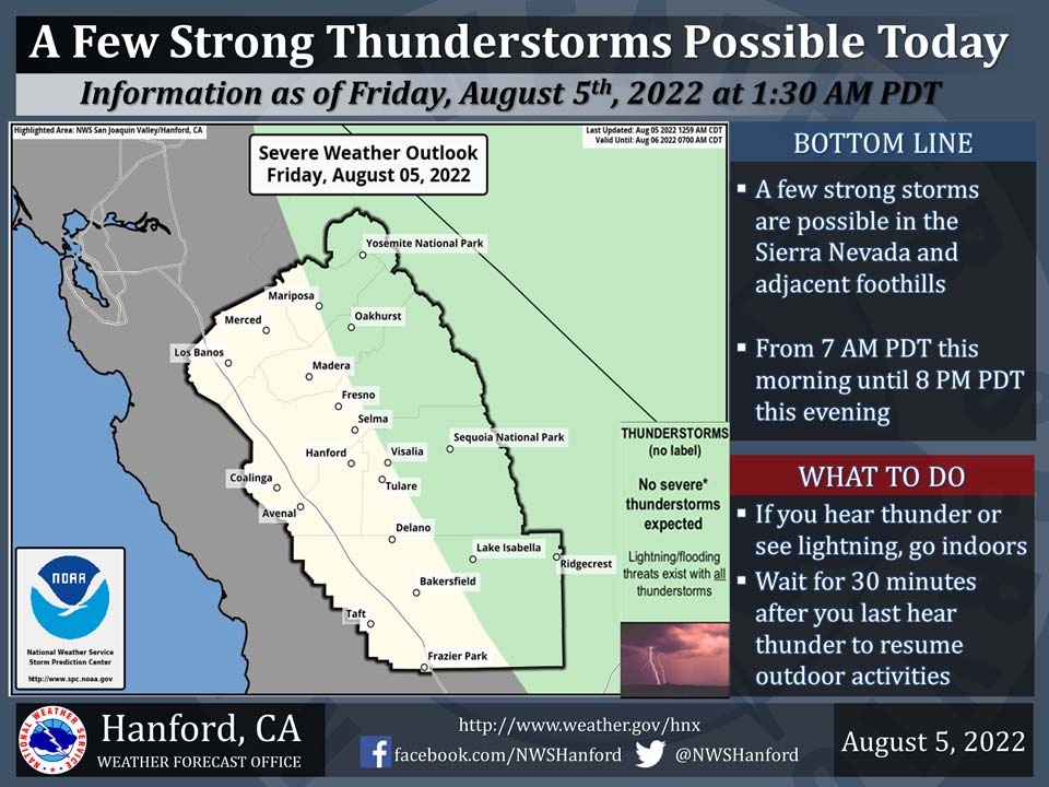
August 5, 2022 - The National Weather Service Hanford Office reports a few strong thunderstorms are possible in the Sierra Nevada and adjacent foothills from 7:00 A.M. this morning until 8:00 P.M. this evening.
Dangerous cloud to ground lightning strikes and wind gusts near 45 mph are a couple of hazards associated with strong thunderstorms.
In addition, any thunderstorm can produce intense rainfall rates, leading to localized flooding.
Area Forecast Discussion
National Weather Service Hanford CA
131 AM PDT Fri Aug 5 2022
.SYNOPSIS...
The monsoon moisture will be the main story until Saturday and
again early next week, as the Sierra Nevada, Tehachapi Mountains,
and the Kern County desert areas will have a chance of showers and
thunderstorms. Otherwise, expect seasonably warm temperatures
through late next week.
&&
.DISCUSSION...
Based on latest radar data, numerous light to moderate showers
will continue in the Sierra Nevada, adjacent foothills, and
eastern portions of the San Joaquin Valley overnight tonight into
the morning hours. A very moist airmass continues to prevail over
much of our portion of Central California with precipitable water
amounts as high as 1.8 inches. It appears we could get a break
from triple digit heat throughout our region and may reach around
3-5 degrees below average, especially if cloud cover remains over
the lower elevations for much of the day. There remains a chance
for showers and thunderstorms that are capable of heavy rainfall
to redevelop over much of the Sierra Nevada into the Kern County
mountains for today. However, it will depend on how long cloud
cover lingers and if any areas clear between now and peak daytime
heating; a lot of cloud cover would inhibit convection and
subsequently mitigate additional storm development.
By Saturday, flow aloft will turn towards the southwest, which
will allow a drying trend through the weekend. Also, expect mainly
seasonably warm temperatures. This will be a minor shift in the
pattern, and enough moisture will remain over the higher
elevations of the Sierra Nevada to provide a slight chance for
afternoon and evening showers and thunderstorms over the weekend.
Current high resolution ensemble guidance suggests this scenario,
as well as the presence of an upper-level low pressure system off
the coast of Northern California. In addition, the cluster
analysis for Sunday also shows this upper-level low persisting off
the coast, though will eventually weaken. We will, however, remain
under the influence of the high pressure pattern, though with
some eastward progression.
Another moisture surge is on tap for early next week, with the
best chances for showers and thunderstorms in the region by
Tuesday. Some light showers and sprinkles are once again possible
in the San Joaquin Valley, while there is a good chance for more
precipitation and thunderstorms in the mountains and desert.
Expect small changes in temperatures for this period, although
cloud cover could make the forecast a bit tricky.
For the latter part of next week, temperatures will rise back to
slightly above average, with some drying trend possible. The
probability of triple digit heat rises to around 40 to 50 percent
in the Central Valley by Thursday, while triple digits are even
more likely in the Kern County desert. Showers and thunderstorms
will remain a possibility over at least the higher elevations of
the Sierra Nevada during the afternoons and evenings.
&&
.AVIATION...
Showers, with MVFR conditions possible at times, will persist over
the Sierra Nevada, adjacent foothills, and portions of the San
Joaquin Valley through this morning. Showers and thunderstorms will
redevelop and may cause IFR conditions due to mountain obscurations
over the Sierra Nevada from 18Z Friday until 03Z Saturday.
Otherwise, VFR conditions will prevail for the next 24 hours.
&&
.AIR QUALITY ISSUES...
On Friday August 5 2022... Unhealthy for Sensitive Groups in Kern
County.
Source: NWS
