


Includes Eastern Madera and Mariposa Counties and Yosemite National Park
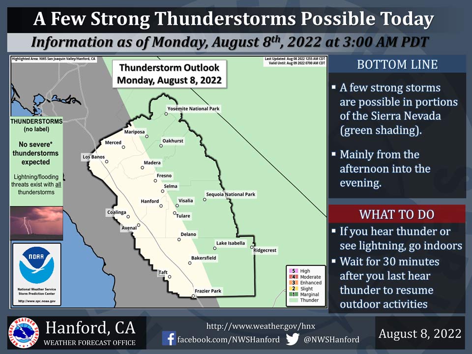
August 8, 2022 - The National Weather Service Hanford Office reports a few strong thunderstorms are possible in the Sierra Nevada, mainly Yosemite NP to Lake Isabella and Tehachapi, this afternoon and evening.
A potential exist that thunderstorms could reach the foothills of the Sierra Nevada as well.
Dangerous cloud to ground lightning strikes and wind gusts near 45 mph are a couple of hazards associated with strong thunderstorms.
In addition, any thunderstorm can produce intense rainfall rates that may lead to localized flooding.
Area Forecast Discussion
National Weather Service Hanford CA
119 AM PDT Mon Aug 8 2022
.SYNOPSIS...
Near average temperatures continues to be the story through
Wednesday. Thunderstorms in the Sierra Nevada are expected to
start back up by this afternoon with chances continuing through
midweek. Warmer than average temperatures return to much of the
Central California interior later in the week.
&&
.DISCUSSION...
Highs yesterday in the lower elevations were seasonably warm, as
temperatures peaked at the mid to upper 90's across the San
Joaquin Valley and around 100 to 106 degrees in the Kern County
desert. Expect a similar, seasonably warm day today, although more
cumulus cloud buildups are likely over the higher elevations of
the Sierra Nevada with isolated thunderstorms possible by the
afternoon as the flow aloft turns more towards the south rather
than the southwesterly flow we have observed the past couple of
days. Despite the temperatures that peaked just barely below the
century mark in much of the Central Valley from Fresno southward
yesterday, NBM probabilities suggest it is unlikely (less than 20
percent chance) that a triple digit high will be observed today
and even through Wednesday. Another chance for showers and
thunderstorms remains mainly in the Sierra Nevada on Tuesday with
little change in sensible weather elsewhere. Latest high
resolution ensemble guidance suggests this pattern remains on
track.
There could be some isolated thunderstorms over the Sierra
Nevada crest again on Wednesday afternoon, as the southerly flow
persists. Afterward, or by Thursday, models continue to be in
agreement in terms of this low pressure system weakening to a
shortwave trough and moving northward just off the coast of the
Pacific Northwest. Due to the movement of this upper-level low,
the flow aloft is projected to return to southwesterly, so this
could mitigate further convection, at least temporarily.
There remains notable uncertainty from Friday through the
weekend regarding the return of mountain storms. High pressure
ridging builds over the Southwest, including Four Corners region
by later in the weekend, so flow aloft could once again revert to
southerly. Though, it remains more certain that warmer than
average temperatures will make a comeback. The likelihood of
triple digit heat in the San Joaquin Valley increases to around 30
to 50 percent probability. However, it does not appear to be a
dramatic warmup for much of our area, so typical August heat will
continue. Some periods of afternoon/evening mountain showers and
thunderstorms cannot be ruled out, as the ridging over the
southwestern U.S. could nudge some mid-level moisture and
southerly flow back to our region.
&&
.AVIATION...
Isolated thunderstorms are possible along the Sierra Nevada crest
from 18Z Monday until 03Z Tuesday. Otherwise, VFR conditions will
prevail for the next 24 hours.
&&
.AIR QUALITY ISSUES...On Monday August 8 2022... Unhealthy for
Sensitive Groups in Kern and Tulare Counties... and Sequoia
National Park and Forest.
Source: NWS
