


Click here for: Siskiyou County McKinney Fire Updates for Wednesday, August 10, 2022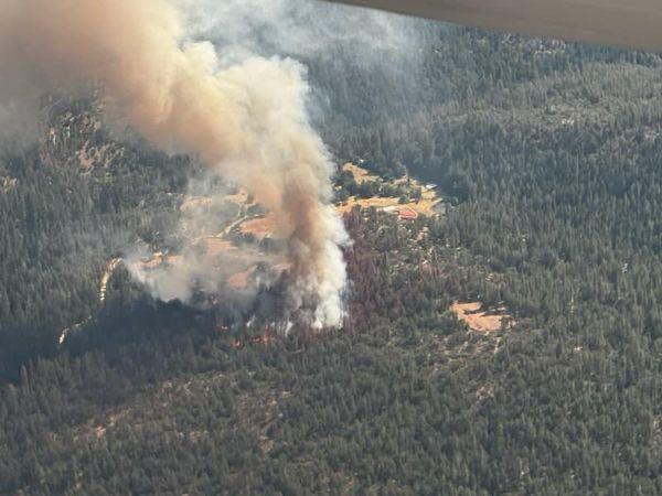
McKinney Fire in Siskiyou County on Friday, July 29, 2022
Credit: InciWeb
Click here for: Siskiyou County McKinney Fire Updates for Wednesday, August 10, 2022
Note: McKinney Fire Community Meeting Video in Fort Jones on Monday, August 8, 2022
Evening Update Per Inciweb: McKinney Fire is now at 60,389 Acres, with 60% Containment, and 3,144 Personnel.
Basic Information
|
Current as of |
8/9/2022, 5:09:58 PM |
|
Incident Type |
Wildfire |
|
Date of Origin |
Friday July 29th, 2022, approx. 02:15 PM |
|
Location |
Klamath River, Siskiyou County, CA |
|
Incident Commander |
Unified Command - US Forest Service & CAL FIRE |
|
Incident Description |
Wildland Fire |
|
Coordinates |
41.819 latitude, -122.885 longitude |
Current Situation
|
Total Personnel |
3,144 |
|
Size |
60,389 Acres |
|
Percent of Perimeter Contained |
60% |
|
Fuels Involved |
Timber (Litter and Understory) Tall Grass (2.5 feet) Brush (2 feet) Narrative: Rollout will continue to be problem. If skies clear and a plume develops, spotting distances will increase. Little to no rain, clouds and smoke will continue to moderate fire behavior. There are multiple green islands near the line if they begin to actively burn expect spot fires over established lines. |
|
Significant Events |
Moderate Backing Creeping Smoldering Narrative: Interior island continuing to burnout, with single tree torching. |
Outlook
|
Projected Incident Activity |
12 Hours: Hold fire within perimeter control lines, Structure defense of values at risk operations continue along the Highway 96 corridor near Walker Bridge, Horse Creek and Scott Bar. 24 Hours: Burning out of interior islands, heavy fuels, group and single tree torching continue to threat control lines. |
|
Remarks |
CIIMT 2 in Unified Command with CALFIRE Siskiyou Unit. |
Current Weather
|
Weather Concerns |
Conditions were sunny, hot, and dry over the incident on Tuesday. High temperatures ranged from the lower to mid-80s on the ridges to the upper 90s in the valley bottoms. Minimum humidity values were 10 to 14% across the entire incident. Winds were light and downslope in the valley this morning, but gusting to 20 mph across the highest ridgetops. Then, winds were generally out of the south in the afternoon with gusts from 22 to 30 MPH. Mostly clear conditions are expected tonight with moderate humidity recoveries across the lower elevations but poor to moderate recoveries across the highest ridgetops. Mainly slope-driven winds across the low elevations. The highest ridgetops will continue to gust up to 25 mph through the night. Wednesday, mostly sunny but not as hot. Gusty winds will continue across the ridgetops through early afternoon, becoming less windy through the day with winds out of the west |
Update 10:25 A.M. Siskiyou County McKinney Fire Operational Video Update for Tuesday, August 9, 2022
Update 6:00 A.M. McKinney Fire in Siskiyou County Briefing and Infrared Maps for Tuesday, August 9, 2022
Update 6:00 A.M. Caltrans Road Conditions
Update 6:00 A.M. Air Quality Measurements
August 9, 2022 - McKinney Fire in Siskiyou County acreage for Tuesday morning: 60,389 with 55% containment.
Location: Siskiyou County, CA
Size: 60,389 acres
Percent Contained: 55 %
Cause: Under Investigation
Vegetation: Timber (Litter and Understory), Tall Grass, and Brush
Number of Personnel Assigned: 3,528
Start Date: Friday July 29, 2022 at 2:15pm
Just in time for Smokey Bear’s 78th birthday today, the Smokey Fire is now 100% contained for 34 acres burned. Crews continue mop-up by adding depth to the containment line to the extent necessary and are assessing suppression repair needs.
WEATHER:
Anticipate high temperatures, reaching up to 100 degrees, in the lower elevations and high 80s in higher elevations. Conditions are expected to be dry with the relative humidity reading 7-8%. Winds from the south / southwest could produce gusts up to 35 mph in high elevations. Large dust devils have been observed and are a hazard to look out for on the fireline from the unstable atmosphere. The fire remains in a red flag warning, keeping fire personnel on high alert for any other initial attacks in the area.
EVACUATIONS:
Multiple Evacuation orders and warnings remain in effect. For current updates on evacuations, visit https://www.facebook.com/SiskiyouCountySheriff and https://www.facebook.com/SiskiyouCountyOES Additional evacuation information and a map can be found on the Zonehaven site at: https://community.zonehaven.com/
A shelter has been established at Karuk Wellness Center at 1403 Kahtishraam, Yreka, CA, 96097.
Highway 96 remains closed from Highway 263 to Horse Creek through the fire area.
Current Forest Orders: Fire restrictions are in effect on the Klamath National Forest. For more information, visit https://www.fs.usda.gov/alerts/klamath/alerts-notices/
A forest closure is now in effect for the McKinney, Yeti, and Alex Fires. Please refer to the links below for specific details: Closure Info: https://www.fs.usda.gov/Internet/FSE_DOCUMENTS/fseprd1047211.pdf Closure Map: https://www.fs.usda.gov/Internet/FSE_DOCUMENTS/fseprd1047212.pdf
Pacific Crest Trail Information: https://www.pcta.org/discover-the-trail/closures
Basic Information
| Current as of | 8/9/2022, 7:19:14 AM |
| Incident Type | Wildfire |
| Date of Origin | Friday July 29th, 2022 approx. 02:15 PM |
| Location | Klamath River, Siskiyou County, CA |
| Incident Commander | Unified Command - US Forest Service & CAL FIRE |
| Incident Description | Wildland Fire |
| Coordinates | 41.819 latitude, -122.885 longitude |
Current Situation
| Total Personnel | 3,528 |
| Size | 60,389 Acres |
| Percent of Perimeter Contained | 55% |
| Fuels Involved |
Timber (Litter and Understory) Tall Grass (2.5 feet) Brush (2 feet) Narrative: Expect mainly active backing fire. As the fire progresses east, road systems will help check fire spread. Rollout will challenge containment lines. There are multiple green islands near the line if they begin to actively burn expect spot fires over established lines. The fire will continue to actively back to the south. Watch for slope reversals as the fire reaches drainage bottoms. As the wind transitions at night, the potential for head fire runs will increase. Areas around Baldy Gap did not burn clean, expect islands near the line to burn out and the potential for reburn either of which will challenge existing lines. Main fire progression will be towards Scott Bar and down the Hwy 96 corridor. Rollout will continue to be problematic and challenge any established lines. If skies clear and a plume develops, spotting distances will increase, and the river and highway will be compromised. Little to no rain on the branch clouds and smoke will continue to moderate fire behavior. |
| Significant Events |
Moderate Backing Creeping Smoldering Narrative: Small pockets of intense heat are still present along the northern and western sections of the fire. Significant interior cooling was evident with the fire interior composed mainly of scattered heat and isolated heat. |
Outlook
| Projected Incident Activity |
12 Hours: Perimeter control focus on direct tactics as well as continuing indirect opportunities and contingency lines. Structure defense of values at risk operations continue along the Highway 96 corridor near Walker Bridge, Horse Creek and Scott Bar. Fire has progressed to Collins Badly lookout in the south and is backing towards Scott Bar, and Humbug drainage, Deadwood Baldy Peak on the east flank. 24 Hours: Burning out of interior islands, heavy fuels, group and single tree torching continue to threat control lines. 48 Hours: Burning out of interior islands, heavy fuels, group and single tree torching continue to threat control lines. |
| Remarks |
CIIMT 2 in Unified Command with CALFIRE Siskiyou Unit. |
Current Weather
| Weather Concerns |
Conditions were sunny, hot, and dry over the incident on Tuesday. High temperatures ranged from the upper 80s on the ridges to the low 100s in the valley bottoms. Minimum humidity values were 6 to 12% across the entire incident. Winds were light to moderate downslope in the morning then were generally out of the south southwest in the afternoon with gusts from 15 to 25 MPH. Mostly clear conditions are expected tonight with moderate humidity recoveries across the lower elevations but poor recoveries across the highest ridgetops. Mainly slope-driven winds across the low elevations. The highest ridgetops will gust up to 25mph through the night. Tuesday, a Red Flag Warning for wind and RH is in effect for the McKinney fire. Tuesday will be our breeziest day with wind gusts up to 35 mph from the south-southwest. |
Click here for: Siskiyou County McKinney Fire Updates for Monday, August 8, 2022
