


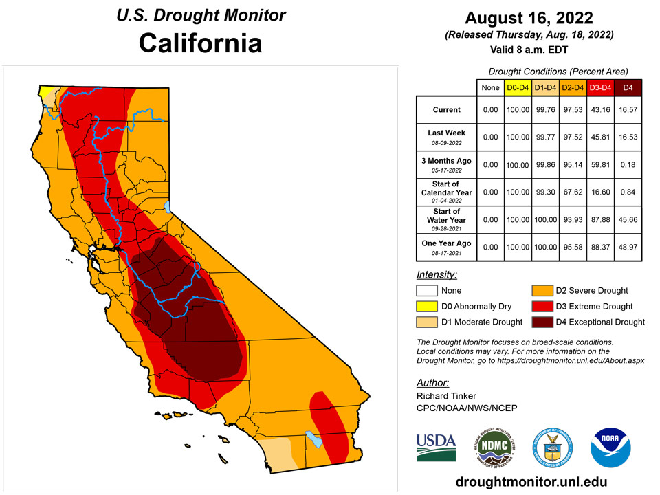
California and National Drought Summary for August 16, 2022
Summary
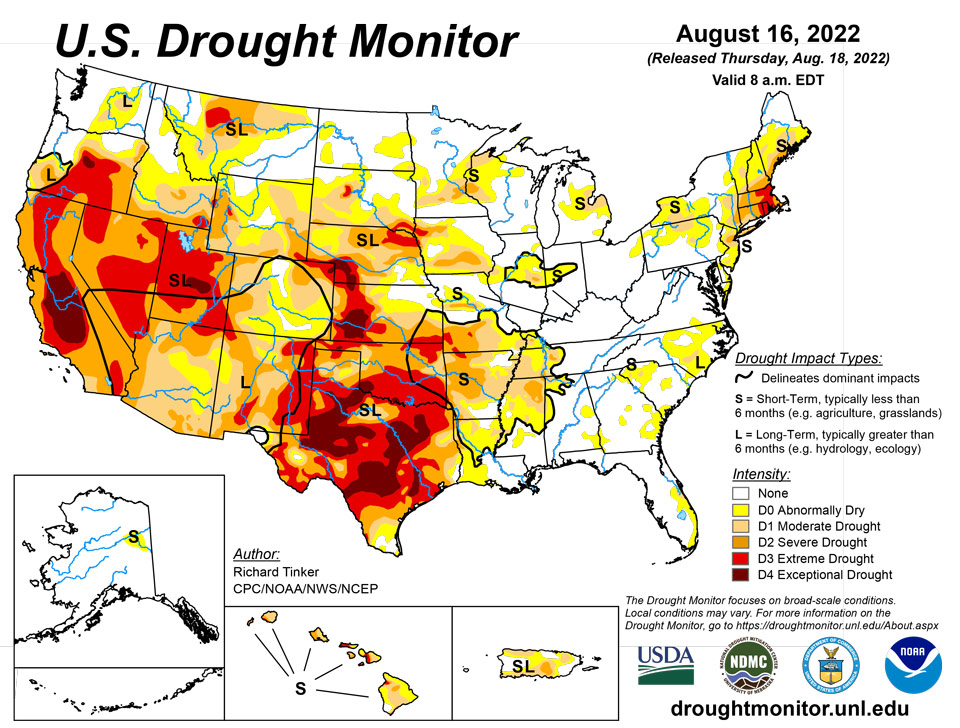
August 18, 2022 - Precipitation again varied widely across the Lower 48 this week, which is not unusual during the summer. Across the interior West, monsoon rains were not as intense as last week, but remained heavier than normal. Several times the normal amount soaked most areas in the western half of the Four Corners Region, much of Nevada, southeastern California, reaching as far north as southeastern Oregon and Wyoming. Other areas receiving widespread heavy rains (and thus some improvement from recent dryness) included Deep South Texas and northwestern Nebraska. Parts of Deep South Texas recorded over 10 inches of rain, and 2 to 3 inches were common across northwestern Nebraska. Elsewhere, relatively narrow swaths of moderate to heavy rain dampened parts of the middle Mississippi Valley, Upper Midwest, and Great Lakes Region. Meanwhile, a broken pattern of moderate to heavy rain covered roughly the southeastern quarter of the contiguous 48 states. The higher amounts were in the 2 to 3 inch range though some small, highly-isolated areas recorded a bit more. In contrast, light precipitation at best fell on the Northeast, which teamed with abnormally high temperatures to induce significant and widespread intensification. Other areas observing light rain at best included part of the Upper Midwest, the north-central and south-central Plains. Conditions were seasonably dry along the West Coast.
Northeast
Despite a few small areas of moderate rain, most of the dry areas in the Northeast Region saw little or no precipitation. This prompted drought intensification and expansion westward away from near-coastal southeastern New England. Extreme Drought (D3) pushed westward across Rhode Island and toward central Massachusetts and easternmost Connecticut. The last 60 days were 2 to 5 inches below normal rainfall from Southeast New England through southeastern New York and northern New Jersey, with shortfalls of 6 inches or more noted in many locations from northeast New Jersey through southeastern New York. Subnormal rainfall extends northward and westward to the Canadian border, but conditions haven’t changed as significantly there. Farther South, dryness and small patches of drought are confined to the Delmarva Peninsula.
Southeast
Rainfall was hit-and-miss along the southern Atlantic Coastal and central Gulf Coastal states, but most sites got at least light to moderate rain (over 0.5 inch). A few patches across central Alabama and the southern Appalachians received less. Such highly variable rainfall patterns are common in summer, resulting in a mix of changes in different areas. Conditions generally improved in southern Virginia, eastern North Carolina, and central Georgia while dryness primarily intensified a bit in parts of South Carolina, adjacent North Carolina, northwestern Alabama, and southeastern Florida. Both 30- and 60-day rainfall deficits increased along the east-central and southeastern Florida coast, with the past month bringing 3 to 5 inches less rainfall than normal along the coast from West Palm Beach northward through the Melbourne area. This prompted a deterioration to moderate drought in part of the east-central Florida Peninsula, with D0 expanding westward into the Kissimmee River Valley and southward to the top of the Keys.
South
Last week’s precipitation – though variable – followed the same general pattern as the precious week. Heavy rains drenched much of the eastern reaches of the Region while lesser amounts and localized deterioration were noted farther west. On significant exception was Deep South Texas, where heavy to intense rainfall brought significant improvement to areas of abnormal dryness and drought. Amounts exceeding 2 inches were widespread south of a line from Webb and LaSalle Counties eastward through San Patricio County, and amounts of 5 to locally over 10 inches drenched areas north of the Mexican border counties. This prompted nearly universal 1-category improvements on the Drought Monitor, with small areas of 2-category improvement where rainfall was heaviest. Extreme drought (D2) or worse are now confined to areas north and west of Duvall County. Elsewhere, increasing rainfall brought additional improvement to the Lower Mississippi Valley and Tennessee, but amounts were generally below-normal from central Texas northward through Oklahoma. Enough rain fell on central and northern Texas to keep areas of deterioration small, but little rain fell from the Red River (South) into northern Oklahoma, where larger areas of intensification were observed. Broad areas of exceptional drought (D4) still cover much of a large area from the southern Texas Panhandle southeastward toward the Gulf Coast. Over the last half-year, rainfall deficits of 8 inches to locally over a foot have affected areas of central Texas near and south of Dallas/Fr. Worth to the Gulf Coast.
Midwest
Similar to the South Region, rainfall in the Midwest was hit-and-miss last week. A mix of deterioration an improvement resulted, but dryness and drought remained considerably more widespread along the western tier of states in the Midwest Region. Improvement was indicated in relatively small, scattered areas across the region while deterioration was fairly common from central Illinois and Iowa northward through most of northwestern Wisconsin. Several bands of extreme drought (D2) persist in the western tier of the Region, with small areas of extreme drought (D3) affecting northwestern Iowa and southwestern Missouri.
High Plains
Light rainfall at best fell on Kansas and farther north across the Dakotas. In contrast, heavy precipitation augmented by intrusions of monsoonal moisture covered large areas from Colorado and Wyoming eastward into western Nebraska. Dryness and drought eased in these areas, with improvement most widespread across the southern half of Wyoming and in the Colorado High Plains. Precipitation in these areas generally exceeded an inch, with 2 to 4 inches falling on several areas from southeastern Wyoming into northwestern Nebraska. Outside of the band of heavy precipitation that brought some improvement to Nebraska and adjacent areas, little or no rain fell on central and southern Kansas, and across most of the Dakotas, with South Dakota recording less rainfall than areas to the north. As a result, dryness persisted or intensified in these areas. Most of the Dakotas and the eastern tier of the Region measured near or below half of normal for the last 3o days, with several patches across the central Dakotas and southeastern Kansas receiving 25 percent of normal or less. In sharp contrast, most areas from central Wyoming through eastern Colorado and western Nebraska reported 150 to locally over 300 percent of normal since mid-July.
West
Ample rains from the North American Monsoon continued through mid-August. Seven-day totals of 1 to 3 inches – with isolated higher amounts – fell across southwestern New Mexico and Arizona northward through much of the central and eastern Great Basin, and the western half of Utah. As a result, several large areas of improvement were noted this week, with the heaviest rains and most widespread improvement covering Arizona. After an extended period of serious drought, the heavy rains have prompted broadscale improvement in monsoon-affected areas. Two-category improvements over the past 4 weeks have occurred in areas recording the heaviest rainfall. Meanwhile, drought and dryness have been changing in the opposite direction across the northern tier. Most notably, abnormal dryness and moderate drought have been expanding across central and western Montana due to deficient precipitation and well above normal temperatures, while intensification has been slower and covers smaller areas in Idaho and Washington. Most of the Pacific Coast states have been dry and periodically hot as well, but this is their dry season, so totals are not far removed from normal.
Caribbean
Conditions across Puerto Rico were unchanged, with generally moderate rains keeping conditions from deteriorating or improving.
The U.S. Virgin Islands remained at the same drought status this week with St. Thomas and St. Croix at D2-SL and St. John at D3-SL. Rain was negligible for St. John this week, while St. Croix received below-normal rain, and St. Thomas received above-normal rain. Temperatures have been above-normal for at the King Airport on St. Thomas and Rohlsen Airport on St. Croix, with both of them reaching or exceeding 90°F from August 1-14.
St. John CoCoRaHS observers reported up to 0.02 inches of rain for the week. SPIs indicated severe drought at all time scales. The Susannaberg DPW 3 well remains very low at 22.88 feet below land surface.
St. Croix CoCoRaHS observers reported 0.11 to 0.43 inches, while 0.30 inches of rain fell at Henry Rohlsen Airport. SPIs indicated moderate drought at 6 and 9 months and extreme drought at 12 months. The SPIs for one and three months were not calculated this week, but pointed toward normal conditions and abnormal dryness at those time scales last week. While the Adventure 28 well remained very low, recent rainfall brought the water level up a fraction of an inch before it trended downward again.
St. Thomas’ CoCoRaHS observers reported 0.68 to 0.84 inches for the week, while 0.30 inches of rain fell at the Charlotte Amalie Cyril E King Airport. The SPIs indicated moderate drought to extreme drought at various time scales. The Grade School 3 well is near a record low, but responded positively to recent rainfall and rose more than two feet.
Pacific
The small area of D0 in east-central Alaska persisted. This area has remained abnormally dry while most other parts of the state have seen precipitation increase. Elevated fire danger persists, even as chances for wildfire development have been declining across the rest of the state.
In Hawaii, another predominantly dry week led to fairly significant areas of drought and dryness expansion as agricultural impacts and surface moisture shortages have been ramping up, with extremely low vegetative indexes noted by satellite. This prompted the introduction of the highest drought designation (D4) in western Molokai, and drought intensifications deteriorated by 1 category in large parts of the state. Exceptions included localized heavy rains on Molokai that removed the D4 that had been there, and a somewhat longer period of above-normal rains led to the removal of D0 in southwest Hawaii Island.
The Republic of Palau received ample rain and was free of dryness.
The Mariana Islands all received plenty of rain and remained free of dryness. Rainfall exceeded 1.79 inches at all locations, which more than enough to meet minimum water needs.
The Federal States of Micronesia were mixed, in terms of precipitation, with most locations reporting more than 2 inches, which is adequate to meet water needs. Kapingamarangi remained at D1-SL and received 1.44 inches. Rainfall has been low for Ulithi in recent weeks, with just 0.84 inches this week, prompting the introduction of abnormal dryness. Pingelap and Pohnpei received the most rain with 6.95 and 8.53 inches, respectively.
The Marshall Islands were free of dryness and drought, but were mixed in terms of rainfall for the week. Jaluit, Majuro and Wotje received less than two inches, but those locations reported enough rain in previous weeks to have enough water. Ailinglaplap, Kwajalein and Mili received around 4 inches of rain.
American Samoa remained free of dryness. All locations received more than an inch of rain, which is enough to meet minimum water needs for the week.
Looking Ahead
The next five days could see heavy rainfall and improvement across a large part of northern Texas and southern Oklahoma eastward along the Arkansas/Louisiana border. Amounts of 2 to 3 inches are expected to be widespread here, with small areas south of the Texas Panhandle and in southeastern Oklahoma expecting over 4 inches of rain. Farther west, the robust monsoon looks to continue unabated. Between 2 and 4 inches are expected over southern sections of the Four Corners Region. But monsoon moisture is not expected to bring tropical moisture and heavy rainfall north of the central Rockies. Farther east, the rest of the southern tier of states are expected to get near or above an inch of rain, with bands of heavier rainfall expected in the Carolinas, southeastern Georgia and the central Gulf Coast. Much of the Upper Midwest and northern Ohio Valley should get several tenths to nearly 2 inches of rain, although the highest totals should be highly isolated. In stark contrast, little or no rain is expected over the contiguous states to the north and west of Kansas. In New England, where dryness has been intensifying rapidly, only a few tenths of an inch of rain are forecast in the areas of moderate to extreme drought along and near the I-95 corridor. Well above average temperatures will exacerbate dryness from the central Rockies northward and westward. Five-day average temperatures could exceed +9 deg. F above normal over the Great Basin and northern Intermountain West. Meanwhile, the southern tier of states – where heavy precipitation is expected – are forecast to average at least 3 deg. F below normal. Temperatures will be close to normal elsewhere, though they could sneak a few degrees above normal in part of New England.
For August 23-27, Odds favor a continuation of above normal temperatures from the Great Basin northward to Canada and westward to the Pacific Coast. In addition, enhanced chances for above-normal temperatures cover the Northeast, the eastern mid-Atlantic region, the immediate south Atlantic Coast, and Florida. Subnormal temperatures are favored from the southern half of the Rockies eastward through the central Plains, middle Mississippi Valley, lower Ohio Valley, and interior Southeast. At the same time, above-normal precipitation is at least slightly over a large area covering the desert Southwest, Intermountain West, Rockies, central and southern Plains, the lower half of the Mississippi Valley, the Ohio Valley, the lower Midwest, Appalachians, and most of the Eastern Seaboard from Georgia through southern Maine. The best chances for abnormally heavy rain extends from northeastern Texas and eastern Oklahoma northeastward through the Tennessee and adjacent Ohio Valleys.
Author(s):
Richard Tinker, NOAA/NWS/NCEP/CPC
Denise Gutzmer, National Drought Mitigation Center
Dryness Categories
D0 Abnormally Dry—used for areas showing dryness but not yet in drought, or for areas recovering from drought.
Drought Intensity Categories
D1 Moderate Drought
D2 Severe Drought
D3 Extreme Drought
D4 Exceptional Drought
Drought or Dryness Types
S Short-term, typically less than 6 months (agriculture, grasslands)
L Long-term, typically more than 6 months (hydrology, ecology)
SL Area contains both short- and long-term impacts
Source: National Drought Mitigation Center
