


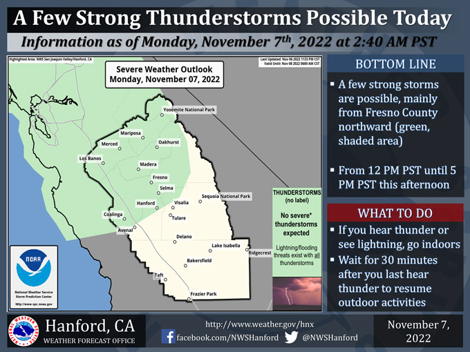
Includes Mariposa County. Madera County and Yosemite National Park
November 7, 2022 - The National Weather Service Hanford Office reports a few strong thunderstorms are possible, mainly from Fresno County northward, from 12:00 P.M. until 5:00 P.M. this afternoon.
Dangerous cloud to ground lightning strikes, small hail, and wind gusts near 45 mph are hazards associated with strong thunderstorms.
In addition, any thunderstorm can produce intense rainfall rates, leading to localized flooding.
Area Forecast Discussion
National Weather Service Hanford CA
241 AM PST Mon Nov 7 2022
.SYNOPSIS...
A strong winter storm system will bring widespread precipitation
today through Wednesday along with gusty winds and well below
normal temperatures. There is a slight chance for thunderstorms
today and Tuesday. Showers taper off on Wednesday then dry and
cool Thursday and Friday.
&&
.DISCUSSION...
Satellite imagery shows a cold upper low spinning offshore from
the Washington coast with some lighting noted. The low will drive
a series of disturbances across the west coast through Wednesday
bringing significant precipitation, gusty winds, and much cooler
temperatures. A Winter Storm Warning is in effect from Yosemite NP
to the Upper San Joaquin River through 10 AM Wednesday. Areas to
the south from the Upper San Joaquin River to the South End of the
Sierra will begin the Winter Storm Warning at 7 AM today. A Winter
Storm Watch for the mountains in Kern County has been pushed back
to begin at 4 AM Tuesday.
Regional radar imagery shows precipitation along a cold front over
northern California sliding southeast. The front will spread light
to moderate precipitation across the San Joaquin Valley and into
the mountains through the morning with continued shower activity
through the afternoon, mainly over the mountains. Colder air aloft
combined with daytime heating will provide for a slight chance of
thunderstorms from Fresno County northward this afternoon. Hi-res
models suggest a lull in activity this evening before the next
wave arrives overnight into Tuesday morning. Models are focusing
on Tuesday morning through Tuesday evening for the brunt of this
event occur. Periods of moderate to heavy precipitation are likely
over the Sierra Nevada as favorable orographics bring enhanced rain
rates. Rainfall amounts for the Sierra Foothills are expected to
range from 2 to 4 inches with potential for rockslides, mudslides,
and debris flows around recent burn scars. Rainfall amounts across
the San Joaquin Valley are forecast to range from one half an inch
across the western side of the valley due to rain shadowing, to as
much as 2 inches across the eastern side of the valley. The desert
could see as much as 1 inch of rainfall but rain shadowing should
limit them as well. Impressive snow amounts are forecast over the
Sierra Nevada with 4 to 6 feet above 8,000 feet. Snow amounts from
2 to 5 feet are possible from 5,000 to 8,000 feet and up to 1 foot
of snow down to 4,000 feet. Snowfall over the Kern County mountains
is expected to range from 6 to 12 inches above 5,500 feet and from
2 to 5 inches from 4,500 to 5,500 feet. The snow level is forecast
to fall to around the major highway pass levels late Tuesday night
into Wednesday morning. There is potential for an inch or less of
accumulation along Highway 58 over Tehachapi pass and Interstate
5 over the Grapevine.
Model ensembles agree with the system shifting east on Wednesday
and showers tapering off through the day. Dry but cool conditions
will prevail Thursday and Friday as upper ridging builds in from
the Pacific. Blended guidance suggests a chance of precipitation
this weekend with pops up to 30 percent. But the majority of the
ensemble members favor dry conditions for this weekend.
&&
.AVIATION...
A cold front moving southeast will bring widespread MVFR and
areas of IFR/LIFR and mountain obscurations in heavier showers.
Isolated thunderstorms possible Fresno County north after 20Z.
&&
.AIR QUALITY ISSUES...
On Monday November 7 2022...Fireplace/Wood Stove Burning Status
is: Burning Discouraged in Fresno...Kern...Kings...Madera...Merced
and Tulare Counties...and Kern (Greater Frazier Park Area) and
Sequoia National Park and Forest.
&&
.CERTAINTY...
The level of certainty for days 1 and 2 is high.
The level of certainty for days 3 through 7 is medium.
Certainty levels include low...medium...and high. Please visit
www.weather.gov/hnx/certainty.html for additional information
an/or to provide feedback.
&&
.HNX WATCHES/WARNINGS/ADVISORIES...
Winter Storm Warning until 10 AM PST Wednesday for CAZ323-324-
326.
Winter Storm Warning from 7 AM this morning to 10 AM PST
Wednesday for CAZ327>331.
Winter Storm Watch from late tonight through Wednesday morning
for CAZ333>336.
Source: NWS
