


California and National Drought Summary for August 11, 2015
Summary
This week, most of the western and northern portions of the country recorded below-normal temperatures while most of the south was above normal. Active weather from the central plains into the Midwest brought above-normal precipitation over much of the region while the dryness intensified over the south and into the Gulf Coast.Hawaii, Alaska and Puerto Rico
Because of favorable rains, D0 was removed in northern portions of the Big Island. No changes were made in Alaska this week. In Puerto Rico, the dryness and heat continue. In the eastern portions of Puerto Rico, D3 was expanded this week while new areas of D1 were introduced in the west and southwest portions of the island.High Plains
Most of the region was cooler than normal this week, with departures of 2-4 degrees below normal from northern Kansas into the Dakotas. Areas of southern Kansas and eastern Colorado were 2-4 degrees above normal for the week. Above-normal precipitation was confined mainly to portions of northern and eastern Kansas, western and central Nebraska, western and eastern South Dakota and western North Dakota, with departures of up to 3 inches above normal observed over north central Kansas. With the cooler conditions and recent rains, D0 was removed from most of Nebraska and northwest Kansas with D1 improving in Kansas as well. In the Dakotas, D0 was removed from southeast North Dakota and northeast South Dakota as well as north central South Dakota. The remaining D0 in east central South Dakota was shifted to include more of the agricultural areas west of Sioux Falls.Midwest
Much of the Midwest was below normal for temperatures this week, especially in the northern portions of the region. Areas of Minnesota, Wisconsin, and Michigan were 3-5 degrees below normal for the week. Areas of thunderstorms produced above-normal precipitation over portions of southern Missouri, southern Illinois, Kentucky, northern Wisconsin, northern and central Minnesota, southern Indiana and Ohio. Areas of southwest Wisconsin continue to miss out on precipitation, leading to agricultural impacts in the region which resulted in a new area of D1 this week. In southern Michigan, D0 was removed this week while D0 was expanded in portions of northern Michigan and in the Upper Peninsula. Eastern Wisconsin also received enough rain to show removal of D0 conditions.South
Warm and dry conditions dominated the region as a “flash drought” situation has developed over the last several weeks. Temperatures were well above normal for the region, with areas of west Texas, southern Arkansas, northern Louisiana and east Texas recording temperatures 6-8 degrees above normal for the week. Most of the region was dry for the week, with only portions of northern Arkansas and northern Mississippi recording above-normal precipitation. Some areas of southern Louisiana were 3 inches below normal for the week. With the hot and dry conditions, rapidly developing impacts were being reported over much of the region. Most areas of east Texas, Louisiana, southeast Oklahoma, and southern Arkansas showed a full category degradation for this week.Southeast
Almost the entire southeast was warmer than normal this week. The greatest departures were over Mississippi, Alabama, and Georgia with readings 2-4 degrees above normal. As it has been for most of the summer, precipitation was spotty; those areas where rain fell had above-normal readings for the week. Dryness continued along the Atlantic coast and into the Carolinas as well as in central Mississippi, western Alabama and the Florida panhandle. Dryness continued over south Florida with D0 pushed to the west this week. Improvements to D0 and D1 conditions were made in central and southern Georgia where the greatest rains fell. In western North Carolina, D0 and D1 conditions were expanded westward as locally dry conditions and impacts started to develop. In northern Alabama, D0 was improved, while in Mississippi, D0 was expanded and D1 introduced in response to a rapidly developing “flash drought” situation.The Northeast/ Mid-Atlantic
Cooler than normal temperatures were recorded over much of the region this week, with only portions of western Virginia and West Virginia having above normal temperatures (1-2 degrees above normal). The coolest readings were over western New York, where temperatures were 3-5 degrees below normal. Precipitation was mixed with most of the region recording below-normal rain this week. Areas of western New York, northern Pennsylvania, southern Delaware and eastern Maryland recorded above-normal precipitation for the week. With the recent dryness, D0 conditions were expanded this week to include more of eastern New York, northern New Jersey, and most of Connecticut.West
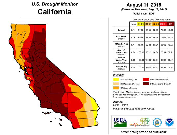
Cooler than normal temperatures dominated the west this last week. Most areas were normal to 5 degrees below normal for the week, with only areas of southeast New Mexico 5-10 degrees above normal. Monsoonal moisture continued to push into the southwest and into portions of Utah and Nevada. Some areas of Arizona were 2 inches above normal precipitation for this week. With the scattered rains, improvements were made to the D2 in southern California as the last several monsoons have been beneficial to this region and precipitation values are near normal over the last 3 years. Improvements were also made in northeast Utah where D1 improved to D0 this week. Continuing on the improvements started last week over northern Nevada, D2 conditions were pushed to the west, improving the D3. Nevada also showed the return of D4 in the west central portion of the state. The earlier rains in the region that allowed for D3 have since subsided and the impacts are again present, especially in the agriculture and ranching communities, allowing for D4 to expand this week. In Washington and Oregon, D3 conditions were pushed to the west as low flows on rivers and streams and warm water temperatures are impacting the region. In Idaho, D3 was expanded in the northern portion of the state where conditions continue to worsen, while some improvement to D2 was shown in the southeast as recent rains helped the region.Looking Ahead
Over the next 5-7 days, the monsoonal moisture in the southwest is anticipated to remain in place, bringing with it up to an inch of rain over portions of New Mexico and Arizona. Some of this moisture will push up into portions of the Great Basin as well as the central and northern Rocky Mountains, where up to an inch of rain is anticipated in parts of Utah and Colorado. The active pattern will remain over the high plains and Midwest, where 2+ inches of rain are anticipated in portions of northeast Nebraska, southeast South Dakota and southwest Minnesota. The southeast will see more moisture, especially along the coastal regions where up to 3 inches is projected. Temperatures are expected to be above normal over the west, the southern plains, and the eastern third of the United States, with departures of 3-6 degrees above normal. The high plains and northern Rocky Mountains look to be 3-6 degrees below normal during the next week.The 6-10 day outlooks show that most of the country has the potential to have good chances of above-normal temperatures, with the greatest probability over the west coast and from New England into the Mid-Atlantic. The exception to this is the high plains and Rocky Mountain region, where the best chance of below-normal temperatures is expected. The eastern half of the United States has the expectation of above-normal precipitation during the period while the area from California into the Great Basin is projected to have the probability of below-normal precipitation.
Author(s):
Brian Fuchs, National Drought Mitigation Center
Dryness Categories
D0 ... Abnormally Dry ... used for areas showing dryness but not yet in drought, or for areas recovering from drought.Drought Intensity Categories
D1 ... Moderate DroughtD2 ... Severe Drought
D3 ... Extreme Drought
D4 ... Exceptional Drought
Drought or Dryness Types
S ... Short-Term, typically <6 months (e.g. agricultural, grasslands)L ... Long-Term, typically >6 months (e.g. hydrology, ecology)
Source: The National Drought Mitigation Center
