


California and National Drought Summary for February 7, 2023
Summary
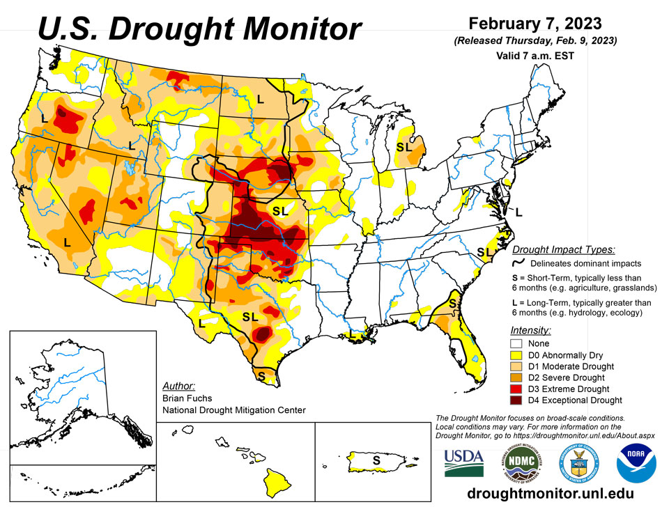
February 9, 2023 - The vast majority of the country was drier than normal for the week with only areas of the southern Plains, South, and Southeast seeing precipitation that was well above normal. Dry conditions were prominent over the central and northern Plains, Midwest, Northeast and Southwest. Most of the country experienced cooler-than-normal temperatures with the greatest departure from normal over the central Rocky Mountains. Warmer-than-normal conditions were observed over the northern Rocky Mountains and in the Southeast with departures of 5-10 degrees above normal. A reassessment of conditions took place for many locations in the West to analyze the current drought intensity levels compared to the suite of indices and indicators used each week. Some adjustments were made based on this analysis and not directly related to anything that took place during the last week.
Northeast
Temperatures this week were cooler than normal in the region with departures in upper New England up to 12 degrees below normal. Precipitation was minimal with most areas recording less than 25-50% of normal. Changes to the U.S. Drought Monitor this week were limited to a slight expansion of abnormally dry conditions in West Virginia and improvements on Long Island where moderate drought was removed and some of the abnormally dry areas contracted.
Southeast
Precipitation was mixed in the region this week where portions of south Florida and the Carolinas and northern areas of Mississippi, Alabama and into Georgia received normal to above-normal precipitation. The wettest areas were in western Mississippi and southeast Florida where over 200% of normal precipitation was recorded. Temperatures were mostly above normal for the week with portions of north Florida and southern Georgia 8-10 degrees above normal. The coolest areas were those that received the most precipitation. Cooler departures from normal temperature were observed over Mississippi, north Alabama and the coastal areas of North Carolina. A wetter pattern over the last several weeks was enough to show improvements in the coastal areas of both North and South Carolina. Moderate drought was removed from South Carolina and abnormally dry areas contracted. North Carolina saw moderate drought areas reduced while improvements were also made to abnormally dry areas. Some long-term dryness is still showing up in portions of the Carolinas, but short-term improvements are lessening that impact. The rains in southeast Florida allowed for the removal of some of the abnormally dry areas along the coast. Northern Florida is still showing a dry signal that is impacting much of the Gulf Coast, but there was enough precipitation this week to hold off on any degradation. Moderate drought was removed from southern Alabama and abnormally dry conditions were removed from northern Mississippi.
South
Cooler-than-normal temperatures dominated the region from south Texas into Arkansas and Louisiana. Departures in south Texas were 8-10 degrees below normal. Portions of central Oklahoma as well as the panhandle regions of Oklahoma and Texas were normal to above normal and departures were only 2-4 degrees above normal. The same areas that were the warmest were also the driest as west Texas into the panhandles of Oklahoma and Texas did not receive any precipitation. The coastal areas of south Texas and into southern Louisiana were also drier than normal. Central Texas into northern Louisiana and southern Arkansas recorded the most precipitation with up to 200% of normal observed. In the Big Bend area of Texas, well above-normal precipitation was also recorded. In eastern Texas where the most precipitation took place, some improvements to abnormally dry conditions were made. With the continued warm and dry conditions over the Oklahoma panhandle, there was an expansion of extreme and exceptional drought this week with dryness going back 18-24 months. Short-term dryness over portions of west Texas allowed for the reintroduction of abnormally dry conditions. The coastal areas of southern Louisiana are being monitored for degradation.
Midwest
Temperatures for the week were cooler than normal in the north and eastern potions of the region with departures of 8-10 degrees below normal in Minnesota and Wisconsin. Areas of Iowa, Missouri and Illinois were warmer than normal with departures of 4-6 degrees above normal for the week. Most of the week was mainly dry for all the Midwest as the storm track remained south of the region. With lingering dryness, portions of northeast Missouri and western Illinois had abnormally dry conditions expand. There were also small expansions of abnormally dry conditions over northeast and southern Illinois and northwest and southern Indiana. Moderate drought was improved over Indiana and Ohio while abnormally dry conditions were improved over much of central Indiana. There is still a signal of dryness from the summer drought, but the consensus was that the conditions over the last few months are starting to improve and negate this dry signal. As frost remains in the soils throughout much of the region, the impact of active winter weather will be hard to know until moisture is allowed into the soils.
High Plains
Most of the region was dry for the week with just some light precipitation over eastern Wyoming and surrounding areas. Temperatures were cooler than normal from eastern Colorado through western Kansas and into Nebraska as well as the eastern areas of the Dakotas where temperatures were up to 5 degrees below normal. Temperatures were near normal to slightly above normal through the central to western Dakotas, eastern Wyoming and eastern Kansas. Minimal changes were made this week as only areas of southeast Wyoming improved with a reduction of severe and exceptional drought. Some improvements to severe drought were brought into western North Dakota based on reassessing the data going back a couple of years.
West
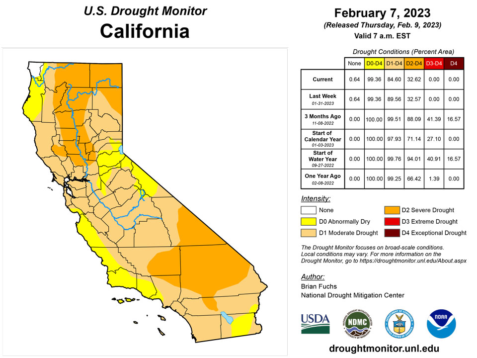
Most of the region had a dry week with below-normal precipitation. The exceptions were in California and Nevada with the Sierras picking up above-normal precipitation. Some coastal areas of California were at to slightly above normal from the central to northern portions of the coast. Areas of northwest Washington as well as south-central Washington into northeast Oregon also recorded above-normal precipitation. Temperatures were cooler than normal over much of the region with departures of 10-15 degrees below normal over Nevada, Utah and southern Idaho. Warmer-than-normal temperatures were observed over much of Montana with departures of 5-10 degrees above normal. With a quieter week in the West, a reassessment of drought intensity levels was made over portions of the region where data and indicators were analyzed going back to the last 3-5 years. In areas where there was not a consensus of support for the current drought intensity levels, improvements were made to better reflect where the data were pointing. For the reassessment, severe and extreme drought levels were reduced in Montana and Utah while moderate drought was improved over portions of California and Nevada. Acknowledging that some of these areas are still being impacted by long-term drought issues, the new depiction is better supported by the data. Some of these areas had minimal data support for the new drought intensity levels and this process may need to continue. Improvements were made in western Wyoming based on the short-term while degradation took place in portions of western and northern Oregon as the short-term has been especially dry.
Caribbean
No changes were made in Puerto Rico this week.
Most of the U.S. Virgin Islands have been drier than normal in the past couple of months. The satellite data (i.e., National Weather Service’s seven-day quantitative precipitation estimates) and station observations show that the rainfall amount received over most parts of the islands was less than 0.4 inches. The one-month Standardized Precipitation Index (SPI) showed that conditions have been significantly dry. However, St. John was relatively better than the other islands. Specifically, St. John (Rafe Boulon/Windswept Beach) reported 0.9 inches of rain this week. The depth to water level at Susannaberg DPW 3 well (St. John, USVI) on February 7 was 10.52 ft below land surface. Even though there is a slight increase in depth to water level, St. John remains at the status quo of drought-free conditions.
St. Croix (Henry Rohlsen AP) reported 0.05 inches of rain this week. Despite recent days with dry conditions, the depth to water level at Adventure 28 Well (St. Croix, USVI) on February 7 was about 28 ft below land surface. Even though an increase in depth to water was observed due to less rainfall in recent days, St. Croix remains abnormally dry for this week. If these dry conditions continue, it is expected to deteriorate to moderate drought by next week.
No rain was reported on St. Thomas (Cyril E. King Airport) this week. There was also an increase in depth to water level at St. Thomas. The depth to water level at Grade School 3 well (St. Thomas, USVI) on February 7 was 10.39 ft below land surface. Thus, St. Thomas deteriorated to short-term moderate drought (D1-S) this week.
Pacific
No changes were made in Alaska this week.
Improvements were made over most of Hawaii due to a recent wetter pattern across the islands. A return of significant trade winds produced several inches of rainfall along the windward slopes of the Big Island. These events, along with regrowth following the late January heavy rainfall across the state, has continued to produce improvements. For Maui County, the late January heavy rain event resulted in a record-setting January total for Pukalani in Upcountry Maui, and the wettest January at several sites since 2004. Hawaii is now drought free for the first time since January 2022.
American Samoa remained free of drought this week. Pago Pago and Toa Ridge (NPS in American Samoa) received 3.84 and 2.19 inches of rain, respectively. With five days missing, Siufaga Ridge (NPS in American Samoa) reported 0.76 inches of rain. Palau IAP (Airai) reported 1.23 inches this week. Koror COOP station also reported 1.06 inches of rain, resulting in drought-free conditions.
Kwajalein received only 0.03 inches of rain this week with two days missing. This week is the third consecutive week with less than 0.5 inches of rainfall. Only 0.43 and 0.23 inches of rain were observed in the past two weeks. Thus, Kwajalein deteriorated to abnormally dry conditions. Similarly, Ailinglapalap reported no rainfall this week with two days missing. Ailinglapalap also had less than an inch of rain in the past two weeks (i.e., 0.75 and 0.65 inches of rain each week), initiating short-term abnormally dry conditions. Jaluit observed 0.57 inches of rain this week with one day missing. However, because of the significant rain (2.57 inches) two weeks ago, Jaluit remained drought free. Wotje reported 1.30 inches of rain (two days missing). Dry conditions continued in the past three weeks at Wotje (i.e., 0.7, 0.68, and 0 inches of rain, consecutively), resulting in short-term abnormally dry conditions. Similarly, drier than normal conditions prevailed on Majuro. Less than 2 inches of rain was observed in the past three weeks on Majuro. Majuro’s reservoir levels also showed a significant decline in the past three weeks. In addition, only 0.22 inches of rain was reported on Majuro this week (with two days missing). Thus, Majuro is in short-term abnormally dry conditions. On Mili, only 0.29 inches of rain was reported this week. However, wet conditions have been observed in the past few months, allowing Mili to be drought free. No depiction was made for Utirik due to missing data.
Except for Kapingamarangi, most parts of Micronesia remained free of dryness or drought. On Kapingamarangi, only 0.58 inches of rain fell. However, Kapingamarangi had heavy rains in January (15.06 inches of rain) and thus improved its drought status to long-term abnormally dry conditions. On Fananu, only 0.74 inches of rain was reported this week, but the island remained free of drought or abnormal dryness because of the significant amounts of rain in January (15.28 inches of rain). On Kosrae, only 0.53 inches of rain was reported this week (with three days missing). However, wet conditions in the past two weeks on the island allowed it to remain drought free. On Lukunor, only 0.24 inches of rainfall was reported this week (with four days missing). Wet conditions were observed in the past two weeks. Thus, Lukunor remains drought free. On Nukuoro, 3.96 inches of rain was reported this week, allowing the island to be free of drought or abnormal dryness. Even though no rain was reported on Pingelap and Yap (six days missing), both islands remained free of dryness due to the wet conditions in the past two weeks. On Ulithi, only 0.05 inches of rain was reported this week (six days missing). Even though dry conditions (0.72 inches of rain) were reported last week, more than 2 inches of rain in the past consecutive three weeks allowed the island to remain drought free. On Woleai, no rainfall was reported this week (six days missing). However, due to the heavy rain in the previous month, it remained drought free. Only 0.54 was reported this week at Pohnpei with four days missing. However, wet conditions prevailed in the past two weeks and previous months, so Pohnpei remained free of dryness. At Chuuk, only 0.03 inches of rain was reported this week with three days unaccounted for, but it remained free of dryness due to heavy rain (4.86 inches) last week.
This week, relatively drier conditions prevailed across the Mariana Islands. Rainfall amounts on Guam and Rota were 0.40 and 0.64 inches, respectively. In addition, dry conditions prevailed in the past two weeks across the islands. However, due to the wet January, the island remained free of dryness or drought. The amounts of rainfall observed on Saipan (IAP, manual gauge), Saipan (ASOS) and Saipan (NPS) were 0.24, 0.56 and 0.51 inches, respectively. Thus, Saipan remains drought free this week.
Looking Ahead
Over the next 5-7 days, an active pattern is expected to develop over the Midwest and into the Southeast, with the greatest precipitation anticipated over Arkansas and southern Missouri as well as throughout the Southeast into the Mid-Atlantic. Temperatures are expected to be above normal over much of the northern Plains into the Midwest and Northeast, with departures of up to 10 degrees above normal. Cooler-than-normal temperatures are anticipated over the West with departures of 8-10 degrees below normal over Utah, Nevada and western Wyoming.
The 6–10 day outlooks show that temperatures are expected to be above normal over the eastern half of the country with the greatest probabilities of above-normal temperatures over the Northeast. Temperatures are anticipated to be cooler than normal over much of the West and Alaska. Much of the country is showing a high probability of above-normal precipitation, with the best chances of above-normal precipitation anticipated to be over the upper Midwest and Great Lakes region. There are above-normal chances of below-normal precipitation over northern Alaska and the Big Bend region of Texas.
Author(s):
Brian Fuchs, National Drought Mitigation Center
Tsegaye Tadesse, National Drought Mitigation Center
Dryness Categories
D0 Abnormally Dry—used for areas showing dryness but not yet in drought, or for areas recovering from drought.
Drought Intensity Categories
D1 Moderate Drought
D2 Severe Drought
D3 Extreme Drought
D4 Exceptional Drought
Drought or Dryness Types
S Short-term, typically less than 6 months (agriculture, grasslands)
L Long-term, typically more than 6 months (hydrology, ecology)
SL Area contains both short- and long-term impacts
Source: National Drought Mitigation Center
